#Phillywx #Philadelphia #weather #PAwx
Friday
Updated Fri 10/20 @ 8:41 AM —For today, periods of clouds and periods of sunshine in the immediate Philadelphia area and western suburbs today, Friday. Rain moves back in this evening likely after 6-8 PM.
A Changing Forecast
Updated Thu 10/19 @ 8:13 PM —Much of the forecast for this coming weekend has changed and there is unusually high uncertainty with the forecast.
A highly amplified jet stream, which had been expected to stay amplified through Sunday, is now expected to flatten rapidly.
As a result of this changing upper air flow, the models are having trouble with placement of the surface low pressure systems, with many models showing multiple areas of low pressure Friday into Saturday.
Case in point is Friday’s weather— There’s a wide range of forecasts, with our NOAA models showing a period of rain here Friday morning in the Philadelphia area
The Canadian RGEM and HRDPS, along with the ICON model have the rain staying east of the Delaware river, in NJ.
The ECMWF is closer to the Canadian/ICON and has the rain mostly east of Philadelphia, but just reaching into the city and immediate suburbs.
With low confidence, I’m leaning towards the Canadian, German ICON and ECMWF models. which keep most of Philadelphia dry during the daytime Friday, especially west of the city. Things change at night as an area of showers is expected to move in from the west by most models, but the ECMWF has it mostly missing our area.
Most models have some rain moving through Friday evening and night, then considerable clearing late morning Saturday. Total rainfall will be light.
Some sunshine with instability cloudiness then develops Saturday afternoon with widely scattered showers possible, but most areas dry. It will be windy.
Sunny with instability cloudiness on Sunday.
I’ll take another at-bat with this forecast tomorrow. Hopefully, I won’t have striked out.
Faster Storm, Less Rain
Updated Thu 10/19 @ 8:50 AM — The coastal storm expected to form Friday into Saturday continues to be much less like last weekend’s rain storm.
A warm front moves through early Friday with showers. Some partial clearing/sunshine possible Friday afternoon, but scattered showers also possible after the front.
A less organized coastal low will bring some rain Friday night into Saturday morning. Most of the energy of this storm will ‘skip’ over our area and the intensification will be further to our north.
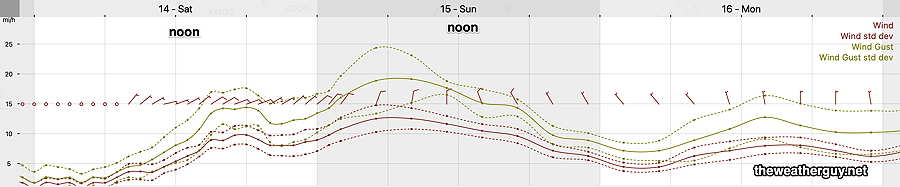
Following some morning and early afternoon showers, some sun with windy/gusty conditions late Saturday afternoon.
Sunday looks to be sunny in the morning, instability cloudiness in the afternoon, with winds and gusts. Colder.
Faster Moving Storm
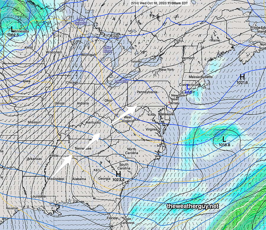
Update (revised) Wed 10/18 @ 6:17 PM — The system that will affect our weather is moving faster than earlier forecasts and cloudiness with this system will move in as early as Thursday afternoon. The rain follows around or before daybreak Friday. Some breaks of sun are possible Friday afternoon.
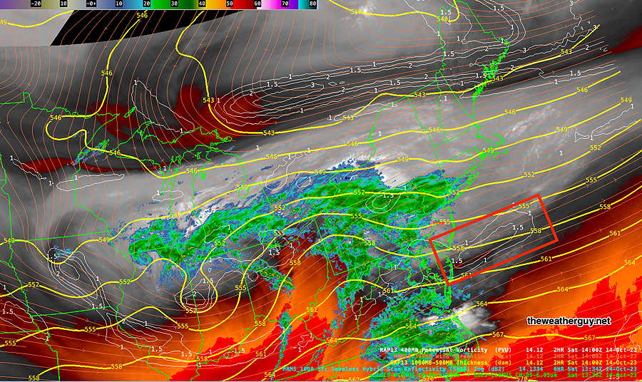
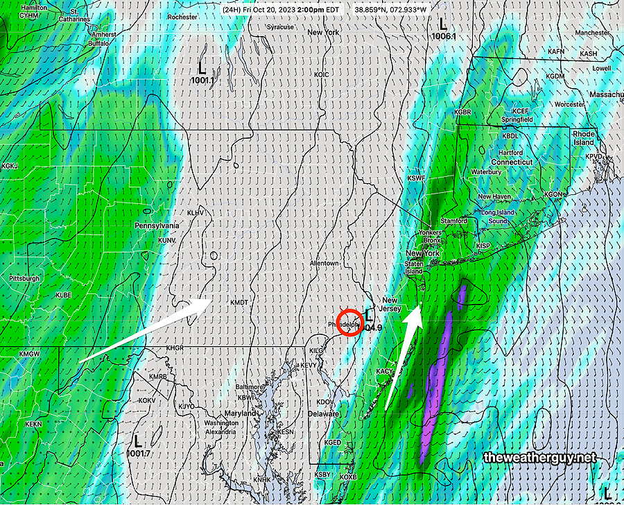
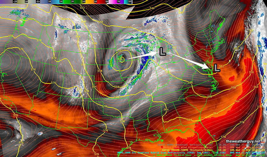
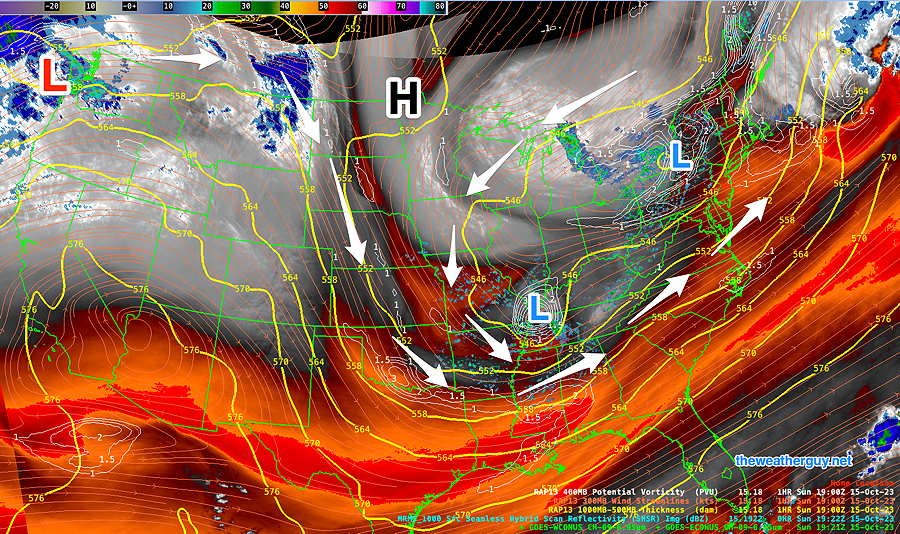
The large storm in the central US will move to the Great Lakes as a secondary low develops along the coast. Here’s the current water vapor image that displays mid and upper level features—
Rain Friday, especially afternoon and evening. Light rain continues through Saturday with increasing wind and wind gusts. Some breaks of sun are also possible Saturday afternoon.
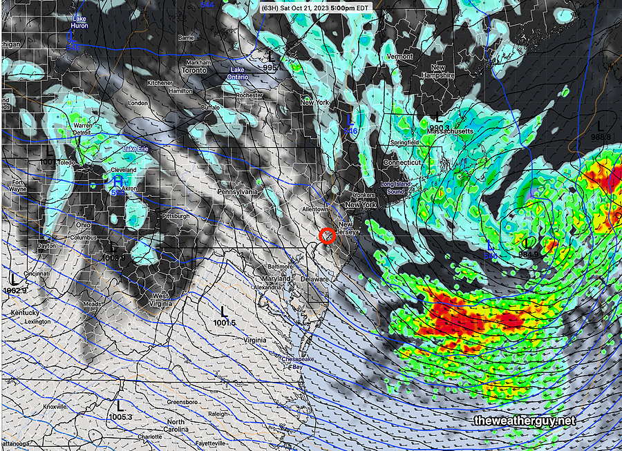
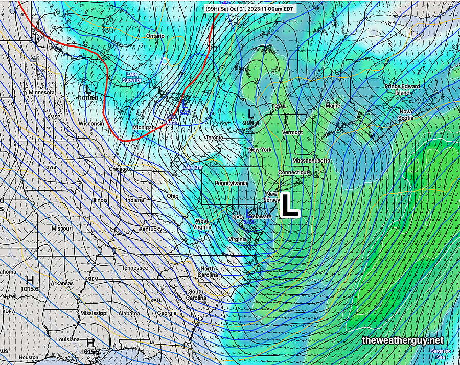
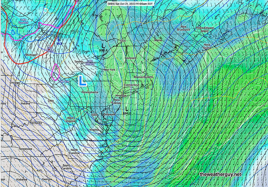
By Saturday morning the coastal low has formed—
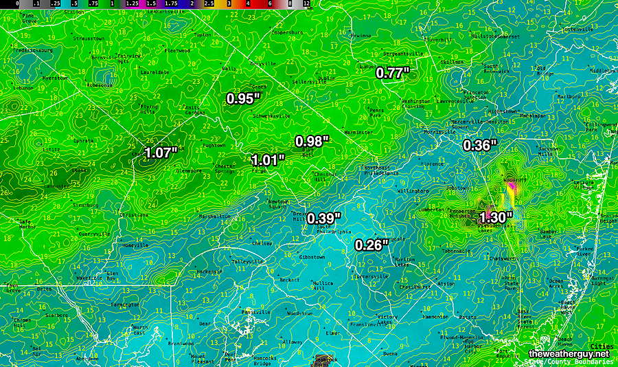
While driving home this afternoon, I heard the term “heavy rain” Friday and Saturday in their forecast. I would use the term “moderate rain” since many models still show a total of less than 0.75 over two days in our immediate area. The rainfall on Saturday looks light with a few possible exceptions mid day.
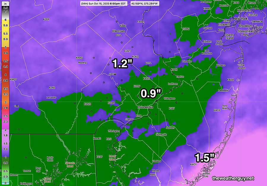
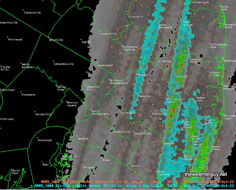
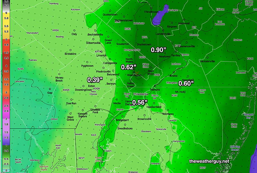
Here’s the latest NBM model total rainfall through midnight Saturday. It’s increased somewhat from this morning’s forecast—
Updated Wed 10/18 @ 10:20 AM — One more thing. It appears that showers will arrive around daybreak Friday, earlier than previously forecast.
Weekend Forecast Update
Updated Wed 10/18 @ 10:01 AM — What had been looking like a repeat of last weekend’s soaker, now appears to be a light, on and off rainfall for Friday through Saturday with totals less than 0.5″ here in the immediate Philadelphia area and westward. Areas east in NJ will have somewhat heavier rainfall, but still not on the order of last weekend’s rain.
As mentioned as a possibility in last night’s update, the heaviest rain is likely to stay east over the Atlantic with the deep low pressure system intensifying further to our north, near New England. The latest NAEFS still maintains plenty of wind and wind gusts.
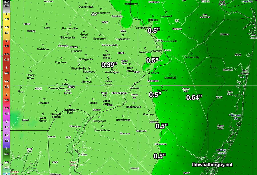
Here’s the latest NBM rain total forecast Friday through midnight Saturday
There’s differences in details with the models and I expect further changes in the forecast with this system.
Weather Update
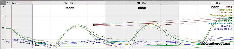
Updated Tue 10/17 @ 7:39 PM — A quick update. Wednesday should have more sunshine and less cloudiness than today. No showers expected.
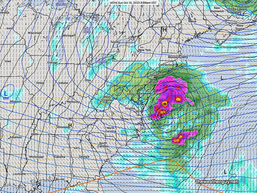
A large coastal storm will develop early Saturday morning. Some of the showers with this system may move in as early as Friday morning.
Despite the strength of this storm, our area may not receive anywhere as much wind and rain as areas in New England. The models differ with the speed and path of the storm, with several keeping the heaviest rain over the Atlantic. Too early to be sure. Nonetheless, Saturday will be another windy and rainy day, with partial clearing Sunday. Temperatures will be quite cool later Sunday with highs reaching only 50º or so.
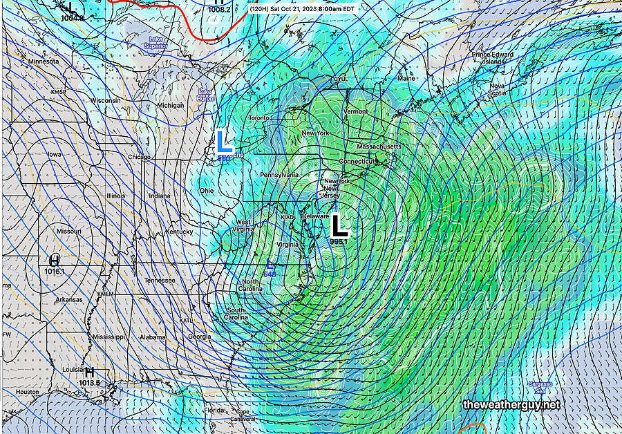
Saturday morning forecast—
Tuesday through Saturday
Updated Mon 10/16 @ 4:50 PM — Once the upper low exits on Tuesday, high pressure builds in for Wednesday and the weather this week can be summed up in three graphics—
As the high pressure system move off, low pressure in the Gulf teams up with a deepening upper trough over the Great Lakes late Friday to create a significant coastal Nor’easter by Saturday morning. Friday will be mostly cloudy with light rain possible in the afternoon.
By Saturday—
The NAEFS did a superb job forecasting last Saturday’s rain storm over a week in advance. There’s every reason to think its forecast for this Saturday’s storm is good.
Previously Posted Sun 8:20 PM —
An upper air low pressure flow will affect our weather Monday through part of Tuesday. High pressure builds in on late Tuesday into Thursday.
A developing system, remarkably similar to this past weekend’s rainstorm, may affect our weather late Friday into next Saturday.
The current water vapor image shows the players for the coming week—
Monday
Weather will be similar to today (Sunday) considerable instability cloudiness, especially in the afternoon. A few sprinkles possible Monday late afternoon (4-6 PM), which should dissipate before the Phillies game.