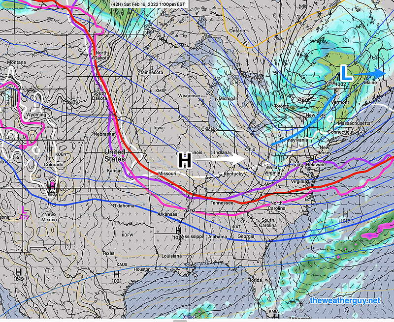
A low pressure system in Canada will drag a cold front through on Saturday. High pressure builds in for Sunday. Milder temperatures for Monday as high pressure departs.
ECMWF forecast for 1 PM Saturday. Low pressure in Quebec will drag a cold front through Saturday. High pressure moves in for Sunday and Monday. (Click on image for a larger view.)
Saturday
A cold front and upper air trough moves through about noontime. While temperatures will be well above freezing at the surface, temperatures at critical levels above ground will support snow. Snow showers or squall will move through about noon to 3 PM. A dusting accumulation is possible in northwest suburbs. (Some high resolution models show some additional, earlier light snow flurries in the late morning.)
Sunny early, then increasing clouds
Snow showers between noon and 3 PM with gusty winds.
Clearing and increasingly cold for the balance of Saturday.
Windy
High temp 43.3º ± 1.6º NBM model Blue Bell. Windy conditions will keep apparent temperatures (wind chill) in the low 30s.
Today’s 12z NBM model forecast temperatures Blue Bell PA
Sunday
High pressure builds in
Sunny breezy and cold. A period of clouds late morning.
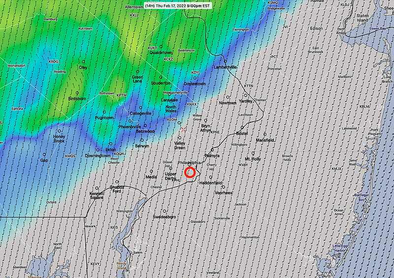
Update Thu @ 9:54 PM — Tonight’s models continue to forecast the front moving through between 5-6 AM with a narrow line of thunderstorms. High wind gusts after midnight still forecast.
Of interest— a secondary cold front moves through early afternoon Saturday. Several models are showing a line of snow squalls about 12 noon to 2 PM Saturday. A dusting accumulation possible but not likely.
Update Thu @ 7:31 PM — The latest HRRR model forecasts a narrow line of thunderstorms moving through between 5 AM and 6 AM Friday morning. The HRRR continues to predict wind gusts over 50 mph after midnight.
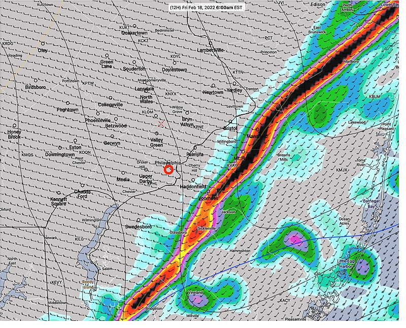
This evening’s 23z HRRR, shows a line of thunderstorms moving through 5-6 AM Friday morning. The HRRR is one of our newer “CAM” models. CAM = “Convection Allowing Models” a model with specific physics packages that predicts high resolution convective activity (thunderstorms.) (Click on image for a larger view.)
Update Thu @ 9:27 AM — The latest model trend is for the rain to arrive later in the evening Thursday and for the front to move through about 5 AM Friday.
Some sun to break out around noon into early afternoon, especially from the city and eastward.
NBM high temps Blue Bell 59.2º ± 5.1º (unusually high uncertainty-spread)
Continued and increasingly windy especially nighttime.
Rain arrives in our area a bit later, between 9-11 PM
Highest wind gusts about 4 AM. Gusts 50-60 mph possible.
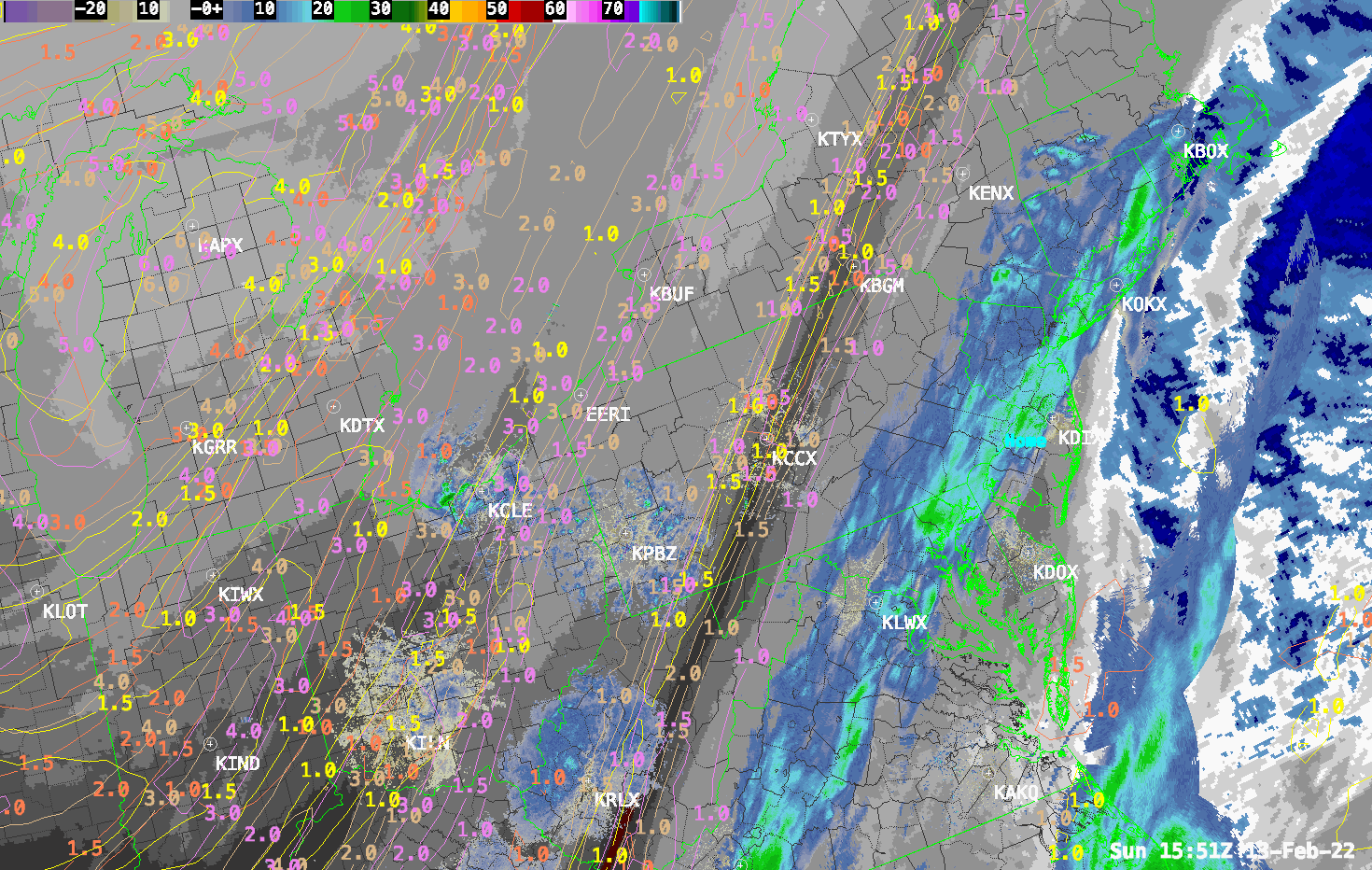
This morning’s 12z HRRR showing simulated radar forecast at 9 PM Thursday evening. (Click on image for a larger view.)
Looking ahead to the weekend, colder, windy weather on Saturday with some cloudiness mid-day and chance of some snow flurries. My Weekend Weather Forecast late Friday afternoon.
Update Wed @ 10:58 PM — Rain starts early evening Thursday. About 0.6 inches of rain, according to tonight’s NBM. The big issue here will be the high wind gusts around and after midnight. Gusts approaching 55-60mph. Rain tapers and ends Friday morning.
Update Tue @ 11:38 AM — Temperatures on Thursday will be over 60º in much of our area. The NBM has 62º ± 2º for Philadelphia and 59.3º ± 2.3º for Blue Bell. Clouds will be a factor; with a thinner cloud deck, we’ll be even warmer.
The storm late Thursday and Thursday night will head to our north. The heavy rain previously forecast will go to our far north and the rain in our area will be nothing special (~ 0.5 inches)
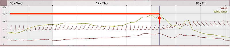
What will be “interesting” will be the winds and wind gusts. The GFS has been forecasting gusts approaching 60mph after midnight Thursday into Friday morning.
GFS wind and wind gust meteogram for Blue Bell PA. High wind gusts approaching 60 mph around midnight and afterwards. (Click on image for a larger view.)
Saturday is looking windy, chilly with some cloudiness as a weak front moves through. Sunday milder. Monday mild with high clouds.
Previously Posted Mon 5:19 PM —
The extended range models are suggesting a changing weather pattern over the next two weeks with a big warm up this Thursday, rain late Thursday into Friday, followed by colder weather again for coming weekend. The week following looks to be milder again.
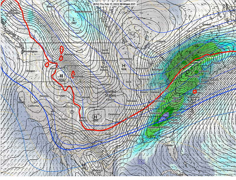
The “interesting weather” this week will be the deep low pressure system expected to move up through the Great Lakes Thursday into Friday. We’ll be on the warm, eastern side of this storm.
GEFS forecast for Thursday at 10 PM (Click on image for a larger view.)
Thursday looks to be in the 60s, but it will be increasingly cloudy and very WINDY. Heavy rain Thursday evening and night into Friday. Windy after the storm departs.
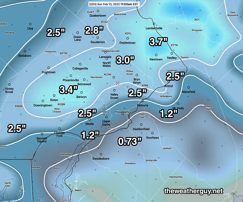
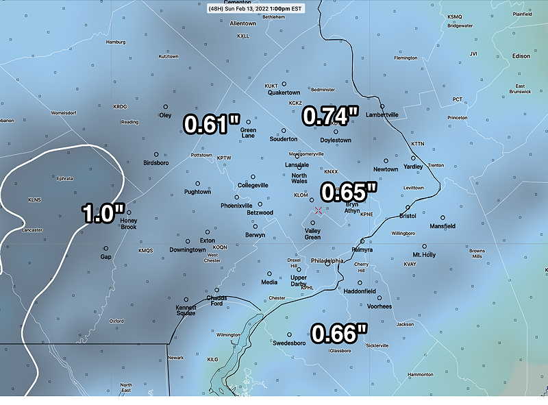
Update Sun @ 11:07 AM — The models continue to indicate another wave of low pressure to continue affect us through 2 PM today with more light snow. With the higher February sun angle, solar insolation through clouds will provide enough thermal effect to prevent much additional accumulation on roadways and dark surfaces. Grassy surfaces may have additional 1/2-1.5″ accumulation.
Sun 6:11 PM Updated Forecast Review — The NAM had temperatures too cold, over-estimating the snow accumulation during the nighttime hours. The GFS did better with the overnight totals.
The NAM and others did much better predicting the continuation of snow into the early afternoon.
Looking at the snow totals below, my mantra “Never Ignore the NAM” was the way to go.
Here are the NWS official snow totals as of this afternoon from this link:
As of 3:47  PM

...Bucks County...
Doylestown                   3.5 in    1121 AM 02/13   Public
Lower Makefield Twp          3.5 in    1236 PM 02/13   Public
Yardley                      3.0 in    0749 AM 02/13   Public
Jamison                      3.0 in    0200 PM 02/13   Public
2 NE Springtown              2.9 in    0700 AM 02/13   CO-OP Observer
Trumbauersville              2.8 in    0120 PM 02/13   Public
Levittown                    2.5 in    0130 PM 02/13   Trained Spotter
2 NW New Britain             2.4 in    0140 PM 02/13   Trained Spotter
Furlong                      2.3 in    0147 PM 02/13   Trained Spotter
2 WSW Langhorne              2.2 in    1243 PM 02/13   Trained Spotter
Jamison                      2.0 in    0729 AM 02/13   Public
1 SE Chalfont                2.0 in    0142 PM 02/13   Public
1 SSW Fricks                 1.5 in    0900 AM 02/13   Public
Hilltown Twp                 1.4 in    0650 AM 02/13   Trained Spotter
1 SSW Sellersville           1.0 in    0700 AM 02/13   CO-OP Observer
Warminster                   1.0 in    0746 AM 02/13   Public

...Delaware County...
Upper Darby                  2.3 in    0310 PM 02/13   Public
Boothwyn                     2.0 in    0140 PM 02/13   Trained Spotter
Aston Twp.                   2.0 in    0144 PM 02/13   Trained Spotter
Chadds Ford Twp              1.3 in    0730 AM 02/13   Trained Spotter
Broomall                     1.0 in    0755 AM 02/13   Trained Spotter
Thornton                     0.5 in    0933 AM 02/13   Public
Folsom                       0.4 in    0631 AM 02/13   Public\

...Montgomery County...
New Hanover Twp              3.5 in    0145 PM 02/13   Trained Spotter
Norristown                   3.3 in    1255 PM 02/13   Trained Spotter
Lower Moreland Twp           3.3 in    0120 PM 02/13   Public
Upper Dublin Twp             3.0 in    0230 PM 02/13   Public
Salford Twp                  2.5 in    0200 PM 02/13   Trained Spotter
Horsham                      2.5 in    0251 PM 02/13   Public
1 W Ambler                   1.5 in    0110 PM 02/13   Trained Spotter
Lansdale                     1.2 in    1200 PM 02/13   Trained Spotter


...Philadelphia County...
Shawmont                     2.0 in    1140 AM 02/13   Public
Fox Chase                    1.3 in    0800 AM 02/13   Trained Spotter
Philadelphia International   0.4 in    0125 PM 02/13   ASOS
Update Sat @ 11:15 PM — Tonight’s GFS has the bulk of precipitation coming through before temperatures drop. As a result, the GFS has considerably less snow accumulation. (less than an inch) Wish I could tell if it’s correct.
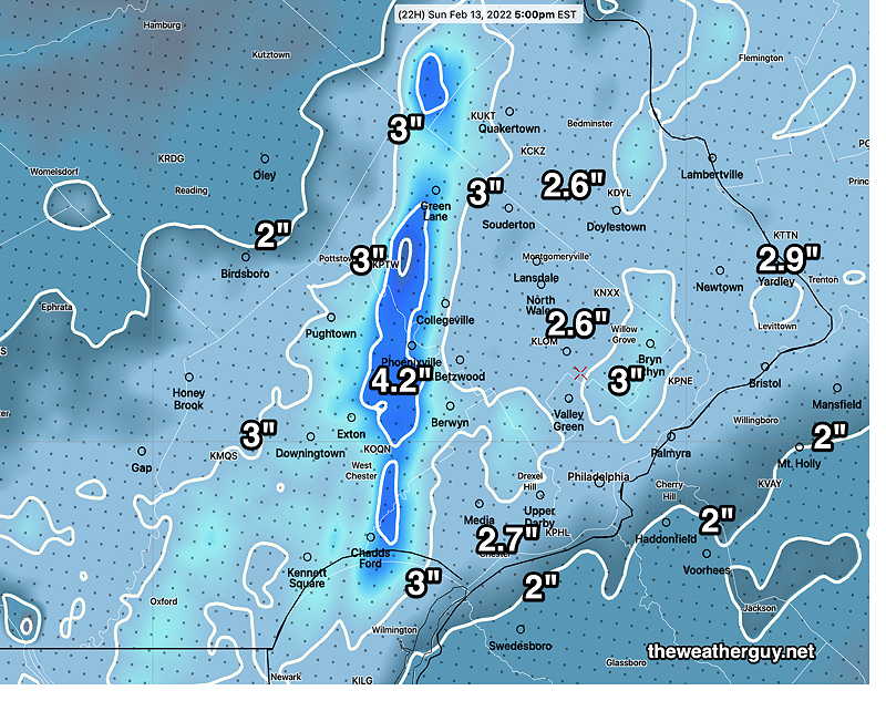
Update Sat @ 10:15 PM —Tonight’s early models have become available. The trend is for a generalized 1.5-3″ snowfall in the immediate Philadelphia area.
Snow tapers in the morning, but models show continued intermittent snow showers possible during the afternoon.
Clouds linger well into the mid to late afternoon. High temp 36º± 2.1º (NBM model Blue Bell)
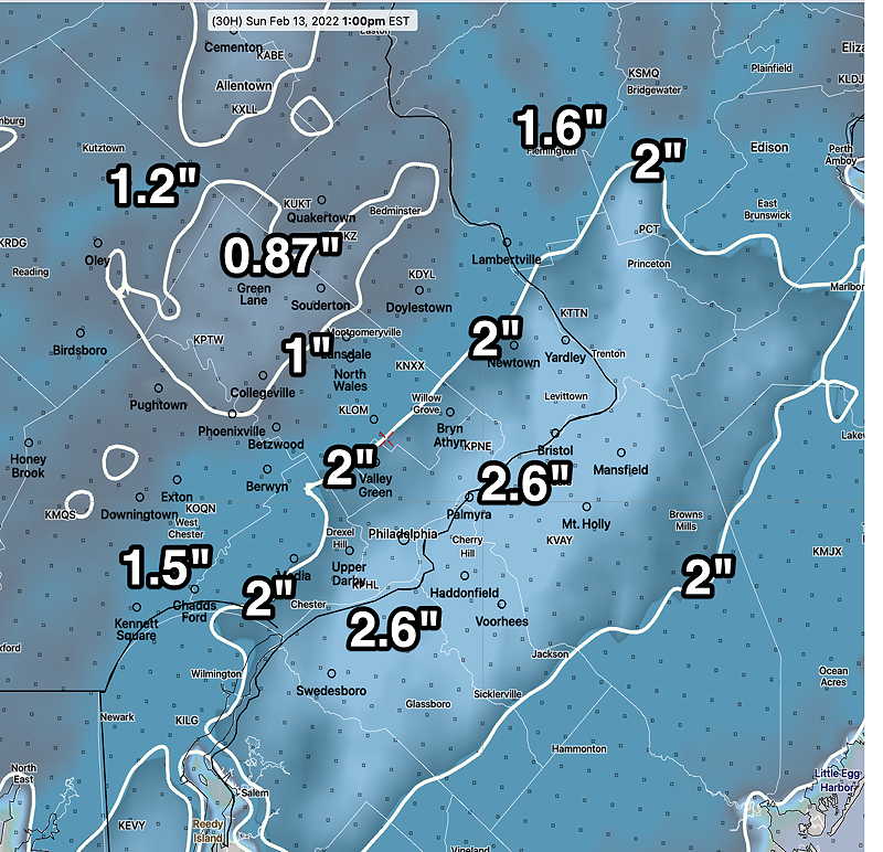
Here’s another high resolution model snow accumulation forecast—
HIRESW-ARW 2.5KM Resolution. (Click on image for a larger view.)
Update Sat @ 6:03 PM — This afternoon’s models have become available. As usual, there’s a wide range of snow totals. The GFS remains on the low side with less than 1 inch in most areas.
What is difficult about this particular forecast: several models are suggesting a relatively narrow band of higher precipitation. Additionally, there are different snow algorithms regarding wet snow accumulation on relatively warm surfaces.
This will initially be a very wet snowfall, until temperatures drop to freezing about 5 AM.
The trend for this afternoon has been for that narrow band of higher precipitation to be falling over Philadelphia and its western suburbs.
After reviewing several models, I’m going to invoke my mantra, “Never ignore the NAM”. The NAM has consistently been on the high end of snow accumulations. So it might be prudent to understand that the NAM might be over-doing it.
Added 7:40 PM: It appears that the models with the lower snow totals have surface temperatures warmer than the NAM.
The latest NAM—
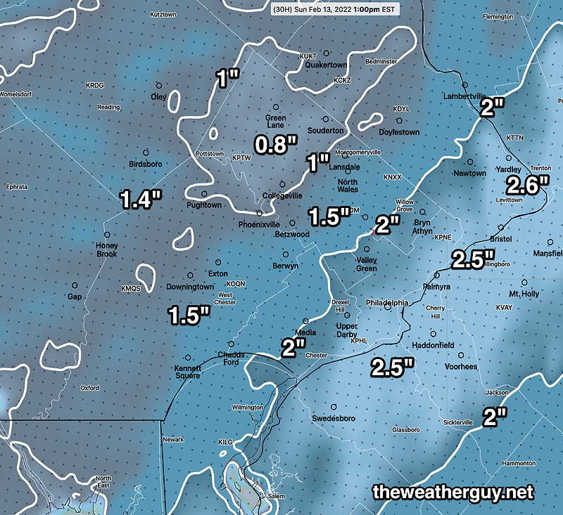
This afternoon’s 18z NAM forecast snow accumulation (Click on image for a larger view.)
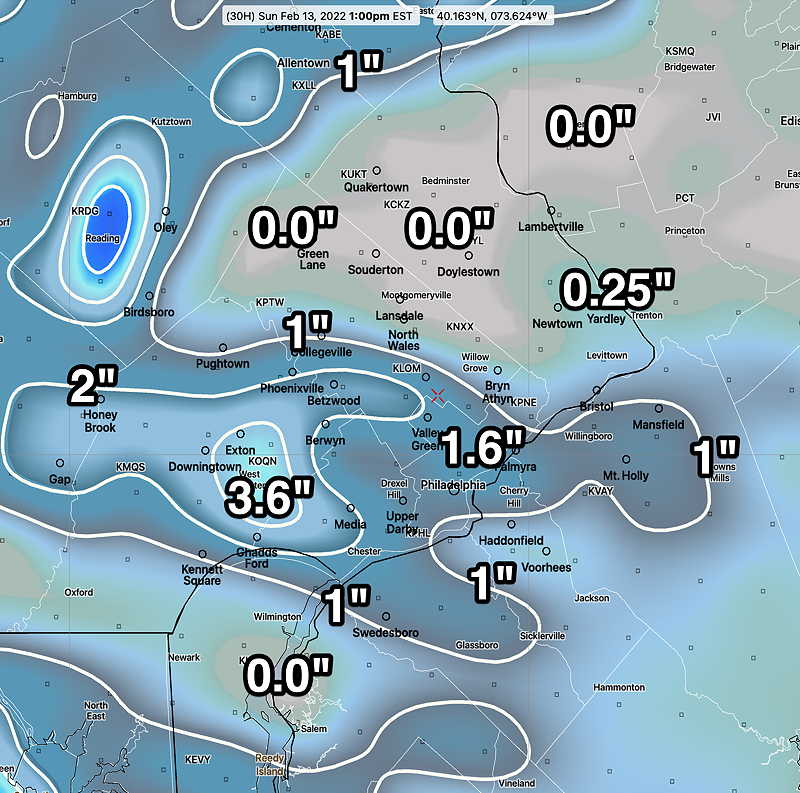
This morning’s Canadian RGEM snow accumulation by 1 PM Sunday (Click on image for a larger view.)
Update Sat @ 10:23 AM — After reviewing last night’s models as well as some of this morning’s models, here’s the current forecast trend:
More snow is possible than had been previously predicted. While the previous forecasts had predicted a coating to 1″, the latest models are predicting in the range of 1-2 inches with some having as much as 3 inches accumulation in some areas.
The light snow, instead of ending in the mid-morning, may be with us into early afternoon.
Accumulations may be highly varied by location.
The trends have been more consistent with the NAM model’s forecast over the past day or so. The GFS, which had been predicting close to zero, is now back on board with over 1″. The ECMWF has also increased its snow totals and has the light snow extending past noon.
NAM forecast, showing very spotty, variable nature of the snow, suggesting more snow-shower type accumulation. (Click on image for a larger view.)HIRESW-ARW 2.5KM very high resolution model. High resolution doesn’t always mean high accuracy. (Click on image for a larger view.)
I’ll try to narrow it down this evening. Stay tuned…
Previously Posted Fri 6:13 PM —
A surface cold front will move through about 8 AM Saturday morning. Winds will shift to the WNW with the frontal passage, but not much cold air will move in with this first front. Saturday will be mild.
Low pressure develops in West Virginia and moves along the front late Saturday night. Cold air moves in during the day Sunday.
I’m leaning towards the Canadian RGEM this forecast. It has done well with recent frontal passages and rain-> snow forecasts.
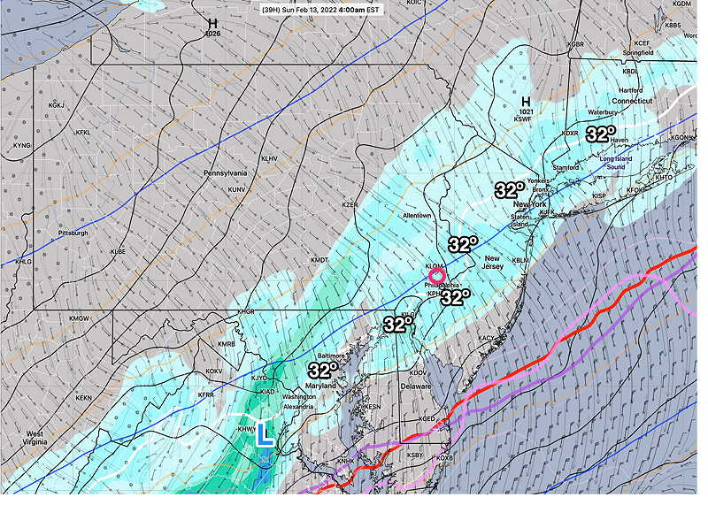
Today’s 18z Canadian RGEM at 4 AM. (Click on image for a larger view.)
Saturday
The cold front moves through in the morning. Clouds in the morning break for sunshine in the afternoon. Somewhat windy. Clouds move back in during the evening. High temp 56.9º ± 2.1º Blue Bell (NBM model)
Low pressure develops in West Virginia around midnight.
Sunday
Light rain changing to light snow 2-4 AM Sunday morning. By daybreak, all light snow. Snow tapers and ends 8 – 11 AM.
A coating to 1.8″ possible. Uncertainty remains regarding location of highest amounts at this time. The NBM and Canadian RGEM are leaning towards lighter amounts. (about 3/4 of an inch)
High Temp 35.0º ± 2.0º Blue Bell (NBM model)
This afternoon’s 18z Canadian RGEM has uniform light amounts of snow accumulation.; NBM model is very similar. ( But GFS and NAM have 1-2 “) (Click on image for a larger view.)