WEEKEND WEATHER OUTLOOK

[su_note note_color=”#d9f2da”]Friday Update 7:30AM:  Earlier Forecast Outlook is on track.

Saturday will have considerable high and high middle level cloudiness.  Some sunny breaks possible, especially during the early morning and  later at times during the early afternoon.   Clouds thicken late afternoon.  Showers possible north and west of Philadelphia during the evening.   High 68.

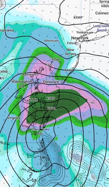
Sunday: Rain, starting early morning, ending mid to late afternoon.  Rain may be heavy.  Mild. High 71 [/su_note]

from earlier in the week:

I was tempted to post the weekend outlook earlier this week and I’m glad I didn’t.  The GFS weekend forecast has changed  since yesterday.

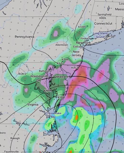
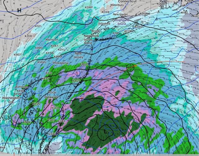
Low pressure moving up from the south was expected to approach on Saturday.  The latest GFS has slowed the approach of this system down to late Saturday— while the Canadian CMC and the European ECMWF hold the rain off until Sunday.

(When the GFS model was updated this past June to what was previously called the FV3-GFS in development, there were known biases in the new model which allowed some systems move up from the south too fast. 

The GFS is being updated on Nov 7th; it’s not clear whether this bias has been fixed.)

Currently, Saturday looks to be a decent day, with clouds moving in during the afternoon.  High 64.   Some showers possible Saturday late afternoon and evening.

Sunday looks to be rainy, especially by early afternoon.  High 67.

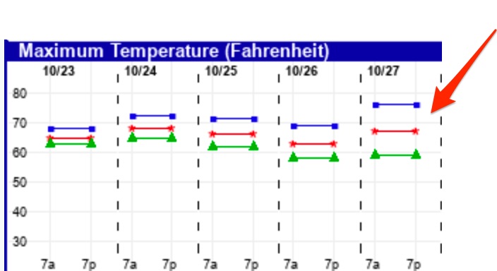
There is still some uncertainty with this outlook; the large spread in forecast high temps for Sunday from the EKDMOS captures the uncertainty:

Ensemble Kernel Density Model Output Stats (EKDMOS) high temperatures showing high spread for Sunday.

[su_note note_color=”#d9f2da”]A week ago, I spoke of very cold weather arriving around Halloween.   The models still show this. Expect a winter-like cold to affect us around the end of this month. [/su_note]

WEEKEND WEATHER UPDATE

[su_note note_color=”#d9f2da”]Sunday morning may be dry with rain starting after noon.

Sunday 7 AM update— Rain looks to start as early as 10-11 AM. The models that leaned towards heavier rain look to be correct.

Sunday 2 PM update— Latest QPF from this morning’s models is closest to that predicted by last night’s NBM – about 0.60 inches of rain, much more further south and east. [/su_note]

Tomorrow’s forecast is of interest because it involves a coastal system that could be considered an analog for future winter storms and forecast dilemmas..

There have been consistent and large differences between the global models (GFS, ECMWF, CMC) and the mesoscale models (NAM, WRF) regarding precipitation amounts.—“QPF”

Today the NAM has been cranking out +1.25 inches of rain for Philadelphia while the global models have QPF’s closer to 0.25 inches of rain.  That’s a huge difference.

The latest National Blend of Models (NBM) unsurprisingly cranks out something in the middle ~ 0.60 inches.

All models have heavy rain in south Jersey.

We’ll probably have to wait for tonight’s models for clarification. If this were a snowstorm, we’d be on the edge of our seats.

The earliest model available tonight is the Rapid Update (RAP)— it is trending towards a later start for the rain and QPF values in the  lower range, except in NJ.

RAP FORECAST for 5 PM Sunday  accumulated rain (QPF)

Just available— Here is tonight’s high resolution NAM Nest, which has rain starting about noon and continues with a QPF of about 0.5 inches by 8pm

NAM Nest forecast precipitation 8 pm Sunday

It will be interesting to see how it plays out .


WEEKEND WEATHER FORECAST

[su_note note_color=”#d9f2da”]Tonight’s NAM continues with a westward trend and has fairly heavy rain for Philadelphia on Sunday. [/su_note]

High pressure will move over us on Saturday.

Saturday looks to be sunny and dry with warmer temperatures and less wind.  High 65.  (Some cirrus clouds move in during Saturday late afternoon.)

The remnants of a tropical low moving up from the south will affect our weather on Sunday.

Most of today’s models have the low pressure system moving just close enough to bring showers to Philadelphia and the immediate western suburbs on Sunday.

NAM forecast for noon Sunday

The NAM is most aggressive with the rain and its western track, but the current GFS, Canadian and ECMWF all have light showers in our area either late Sunday morning or early afternoon. (Heavier rain in NJ.)

The NAM has been consistent, but may be over-doing the rain.

An easterly wind flow and clouds will keep it chilly with a high of 57.