
#Philadelphia #weather #PAwx
Monday Night/Tuesday Snow
Posted Sunday 01/14/24 @ 6:40 PM — Watching the Cowboys lose and waiting for tonight’s NAM run.
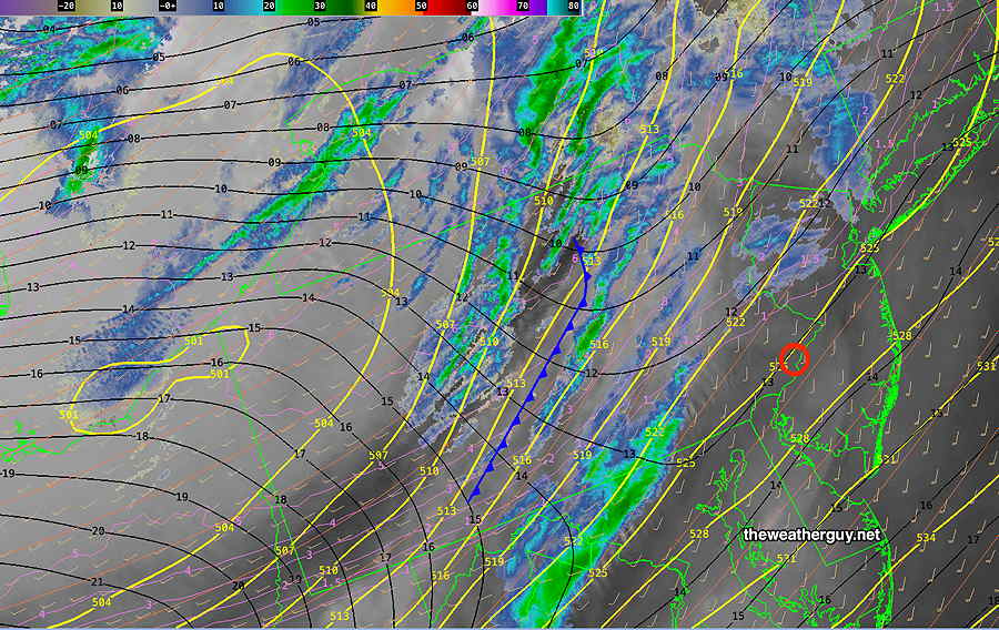
Here’s the trend. This storm has become more interesting, as some of the precipitation may mix with sleet and rain from the city eastward on Tuesday morning before ending, limiting the total snow depth for the storm. Models are ranging from a generalized 1 inch total (GFS), 1-2 inches (ECMWF) and 2-3 (NAM)
I’ll be updating after the next NAM before 10 PM.
Sunday & Tues Snow Update
Posted Sunday 01/14/24 @ 10:21 AM — Just a quick update. The arctic front is in central PA and will move in with rain showers followed by a quick changeover to snow flurries. Timing is about noon to 3PM. The most activity may be north of the Philadelphia area. Increasingly windy and gusty through the daytime hours. High winds about 2 -3 PM.
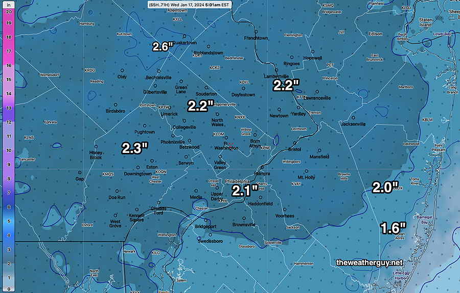
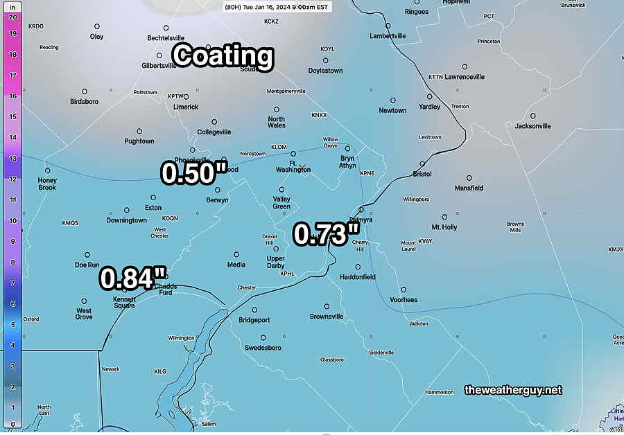
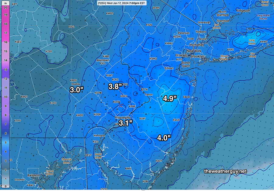
As for the snow late Monday into Tuesday, most models have come together with a generalized 2-2.5 inch snowfall. More specifics later this afternoon. Here’s the latest 13z NBM model snow total forecast—
Sunday Forecast Update
Posted Saturday 01/13/24 @ 9:48 PM — The sharp arctic front moves through with strong winds, dark clouds, and a fast moving squall-type line that may start as rain showers but likely ends as snow showers. It’s forecast to move through 11AM west 1 PM east.
Wind gusts 40-50 mph as the front approaches and continues through much of Sunday afternoon.
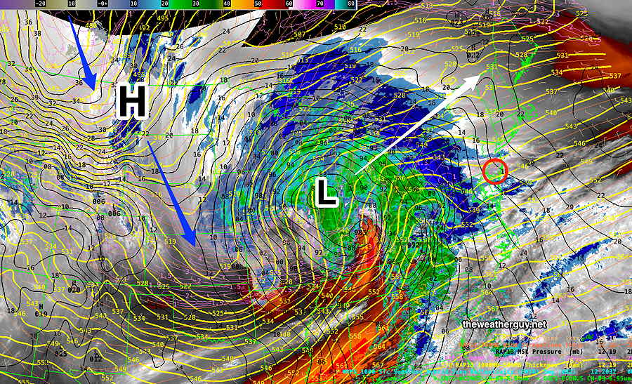
Regarding the system(s) that approaches late Monday, it’s becoming clear that the models are having trouble with the forecast because the energy is divided between two jet flows. The northern system will result in some snow Monday night into early Tuesday morning. About 1-2 inches of snow are likely by Tuesday morning. The southern stream system, which has much more moisture, will move mostly to our east.
The NAM, German ICON and Canadian models are the most aggressive with the snowfall totals. Here’s the latest NAM, just available—
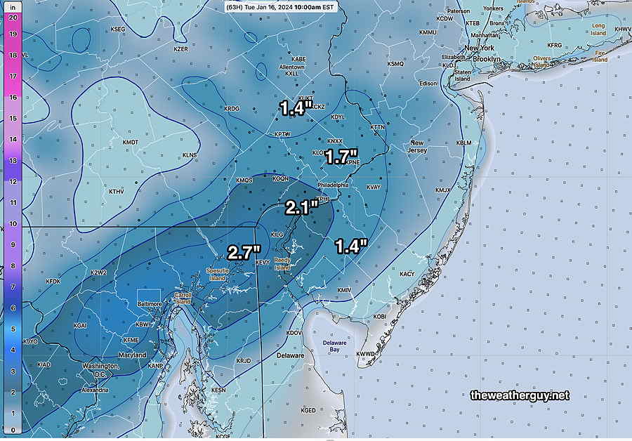
The NAM above only forecasts out to 84 hours, so additional snow after that point isn’t shown.
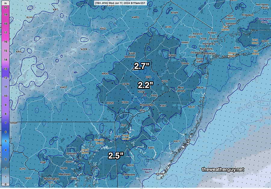
Here’s the latest model blend (NBM) which forecasts out much further in time—
I still expect these forecasts to change over the coming days. This dual system is more difficult to model than most. Stay tuned.
Snow Outlook
Posted Saturday 01/13/24 @ 4:02 PM — It looks like we’re going to have a snow squall come through about 11 AM to 1 PM from west to east on Sunday. A fast burst of snow showers with gusty winds even though temperatures will be well above freezing.
The models are back to predicting about 1-2 inches of snow in our area, starting Monday evening from a coastal system. (The latest NAM shows somewhat more snow in some areas.) Still a low confidence forecast.
Update
Posted Saturday 01/13/24 @ 11:10 AM — These showers moving through at this morning were shown on last night’s 06z models. Somehow, I got caught up in the Tuesday snow forecast and I didn’t look last night’s forecast for this morning. (Gee, I hope I don’t lose this job!)
Anyhow, now that the showers are moving through, I reviewed which models captured it. Last night’s 00z models (7 PM EST) didn’t show much. The 06z models (1AM EST) did.
BTW, I’ve been paying considerable interest in the beta version of the RRFS model being developed; the NOAA Model Development Group is using AWS to distribute these experimental model runs.
The RRFS is far from perfect, but some of its forecasts regarding light rain seem to be at least as good (light rain) or better (cloud cover) than the HRRR. It’s still at beta version 0.77 and may not become operational until late 2024 or very early 2025.
Anyhow…
For Sunday, the arctic front moves though between 11 AM and 1 PM Sunday with some snow flurries. Windy with plummeting temperatures.
Regarding the Tuesday forecast, the Tuesday period has just come into the range of the NAM model. The NAM does show some precipitation here but interestingly, it shows it too warm resulting in a light mix of rain sleet and snow. So, there’s still an uncertain forecast for Tuesday’s storm.
Posted Saturday 01/13/24 @ 9:04 AM — One more thing. It does appear we will have a line of snow flurries move through Sunday, about noontime with the arctic cold front expected to pass through. Temperatures plummet in the afternoon. The rest of the weekend forecast posted yesterday remains intact.
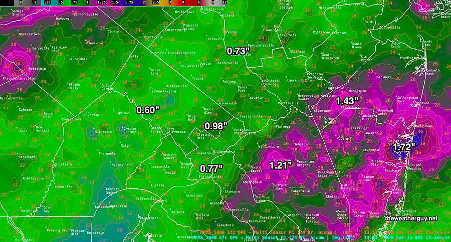
Posted Saturday 01/13/24 @ 8:51 AM — Speaking of forecasts, the snow storm that was a possibility for Tuesday is looking to have a more eastward track. The ECMWF was forecasting this from the start. As a result our area now looks to get only a coating to an 3/4 of an inch of snow on Tuesday. So forget about those snow totals I knowingly posted prematurely yesterday. Some models (Canadian, German ICON) still show somewhat heavier snow, so the forecast remains uncertain.
Here’s the latest GFS snow forecast which shows generally a coating. From experience, low snow totals in this range can mean virtually no accumulation
Previously Posted Fri 5:10 PM —
Deep low pressure will move into the Great Lakes area with another round of rain and winds tonight (Friday) —
Friday Night – Saturday
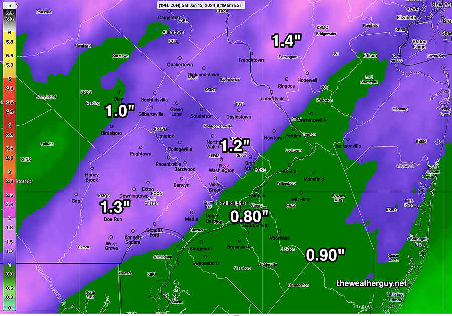
Clouds moved in somewhat later than had been forecast on Friday and the rain start may be delayed until 8-10 PM. The NBM is still forecasting similar amount of rainfall in a very short period of time—
Winds will increase towards midnight and be gusting 40-50 mph by 1AM, and will remain gusty into Saturday.
The rain ends Saturday morning before daybreak and there will be very gradual clearing. Plenty of clouds in the morning, perhaps with some sunny breaks. Still more clouds and sun in the afternoon.
Temperatures will be falling throughout the day, from a high in the 50s early morning to near 30º by evening. Quite windy with gusts near 40 mph throughout much of Saturday.
Sunday
A secondary cold front moves through Sunday morning with considerable cloudiness and gusty winds. Scattered snow flurries are looking likely as the front moves through mid-day. A mix of clouds and some sun Sunday afternoon and continued windy. High temperatures again early, about noon and then falling.
Late Tuesday into Wednesday Possible Snow
There’s still considerable spread regarding the forecast of a coastal storm Tuesday into Wednesday. I’ll be covering it over the weekend, but current best guesses is 2-5 inches on our area.
It’s really too soon to be posting this and it will certainly change—
Check back over the weekend for updates. BTW, there’s a chance of another storm next Friday into Saturday.