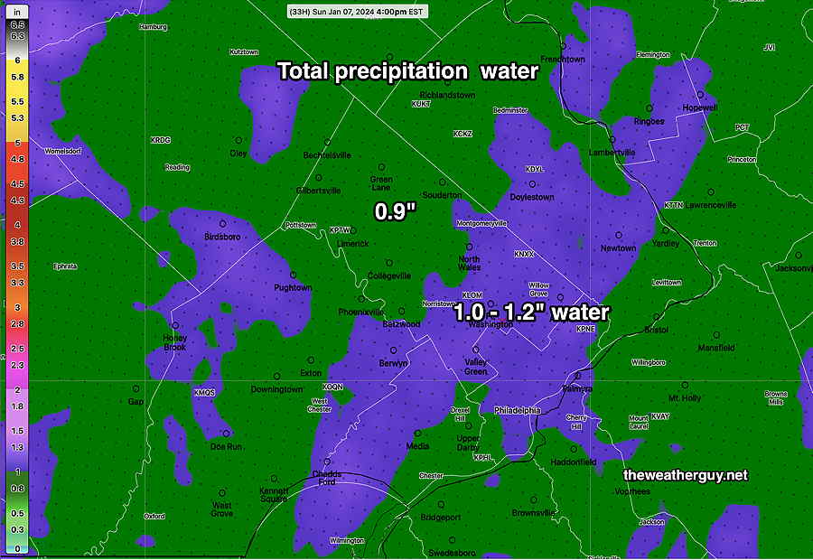
Posted Sunday 01/07 @ 10:11 AM —How much precipitation (water) did we receive (combined rainfall plus snow water equivalent)?
MRMS combined rain gauge & radar-based measurement of rainfall received. Color shading is in inches. Line contour numbers are in mm (25.4 mm= 1 inch) (Click on image for a larger view.)
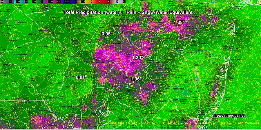
With recent heavy rains and this recent past rainfall/snowfall, the concern exists for flooding with Tuesday night’s upcoming rain storm.
Sunday Forecast Update
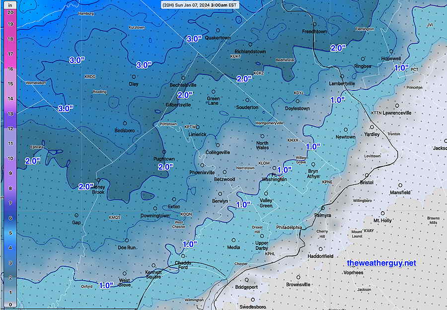
Posted Sunday 01/07 @ 9:42 AM — Colder air has moved in aloft and some of the the precip is changing to snow flurries this morning. No further accumulation is expected.
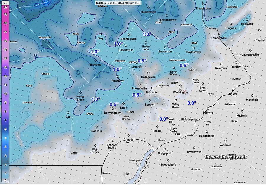
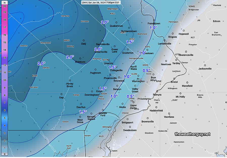
There was a wide range of snow totals, fairly well-predicted by the model forecasts. The “official” snow totals for our region can be found here.
The storm is departing and clouds are expected to linger until early to mid afternoon. (In NJ, for the Eagles game, it will be cloudy with some light spotty rain and or snow showers possible.)
We should see some clearing skies here about 2-4 PM. High temps about 40-42º.
A major rain storm is forecast for Tuesday into Tuesday night with temperatures approaching 60º. With recent heavy rains and areas of snowfall, flooding is appearing quite likely.
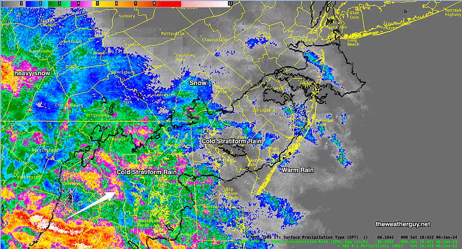
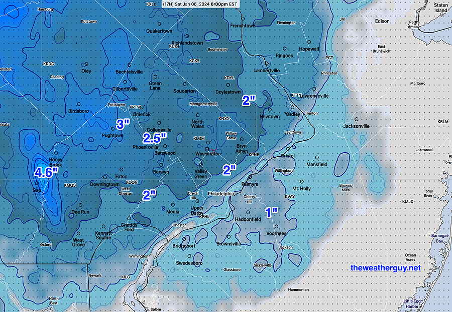
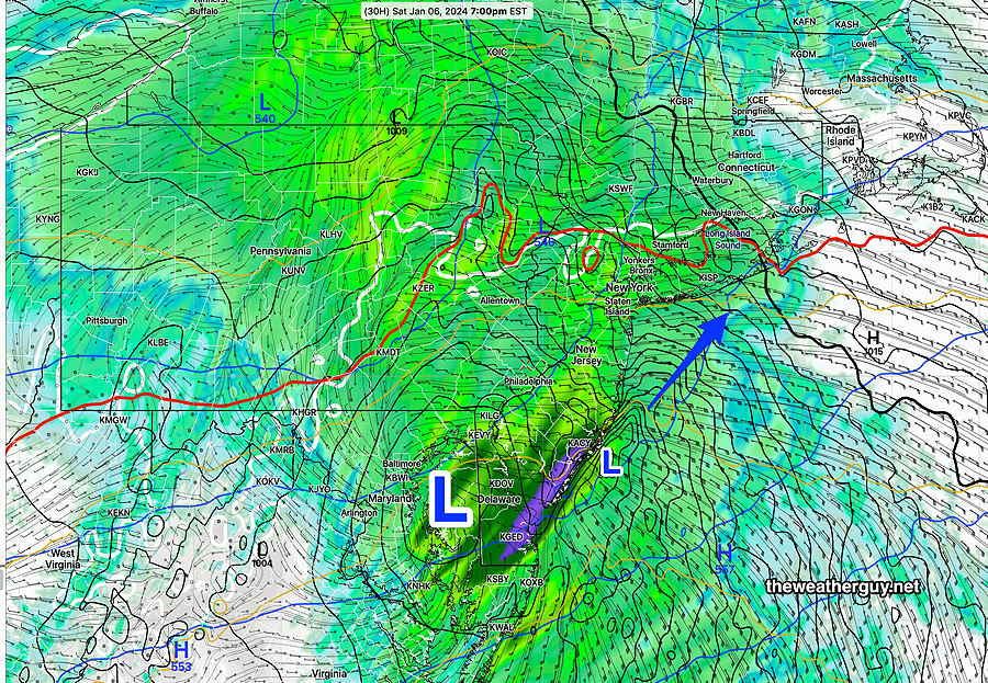
Posted Saturday 01/06 @ 2:21 PM — Heavier snow and a changeover to heavier rain has begun to move into our area. Still heavier rain is poised to move in—
MRMS Precipitation RATE with blackcontourindicating edge of Precipitation Type. The rain-snow line is just southeast of the city at 1:42 PM (Click on image for a larger view.)
There hasn’t been any significant change in the forecast snow amounts from this morning’s update. FYI, this morning’s HRDPS model joined the NBM with similar snow amounts.
I was hoping that the new, still-experimental RRFS model would be available for this storm, but they’ve been updating the model this week and it was not being run. To my delight, the NOAA Model Development Group ran it this morning. Here’s the RRFS snow forecast—
01-06-24 12z Experimental RRFS model under development. Snow forecast for today. (Click on image for a larger view.)
Saturday Forecast Update
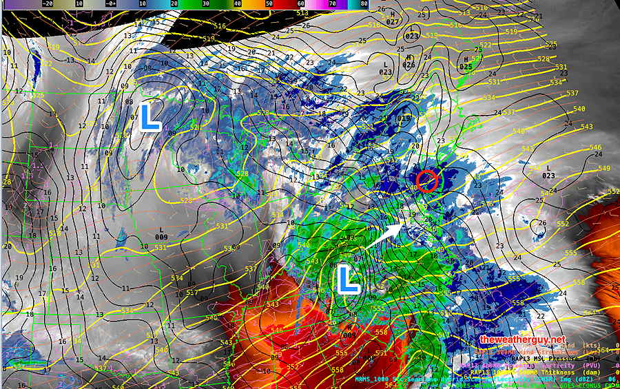
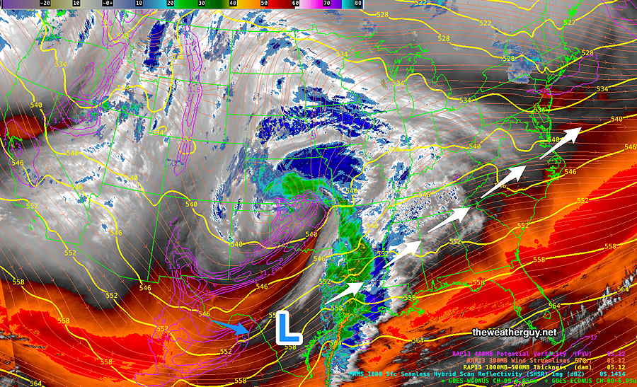
Posted Saturday 01/06 @ 9:13 AM — The system is approaching as forecast—
Current satellite water vapor image (~ 9 AM) with superimposed RAP model 500-1000 mb thickness lines (yellow), Mean Sea Level Pressure isobars (black contours) potential vorticity (fine violet contours) with superimposed MRMS RADAR.
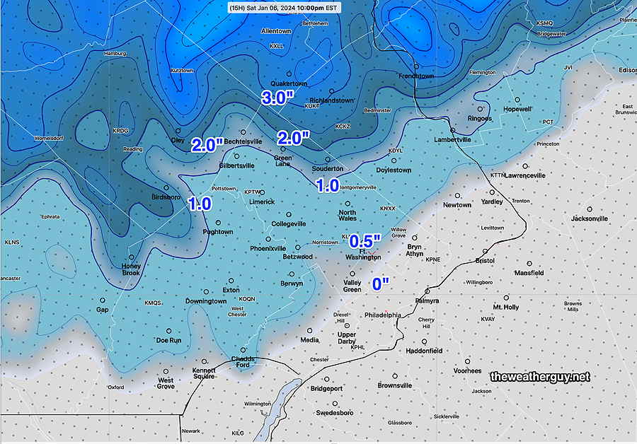
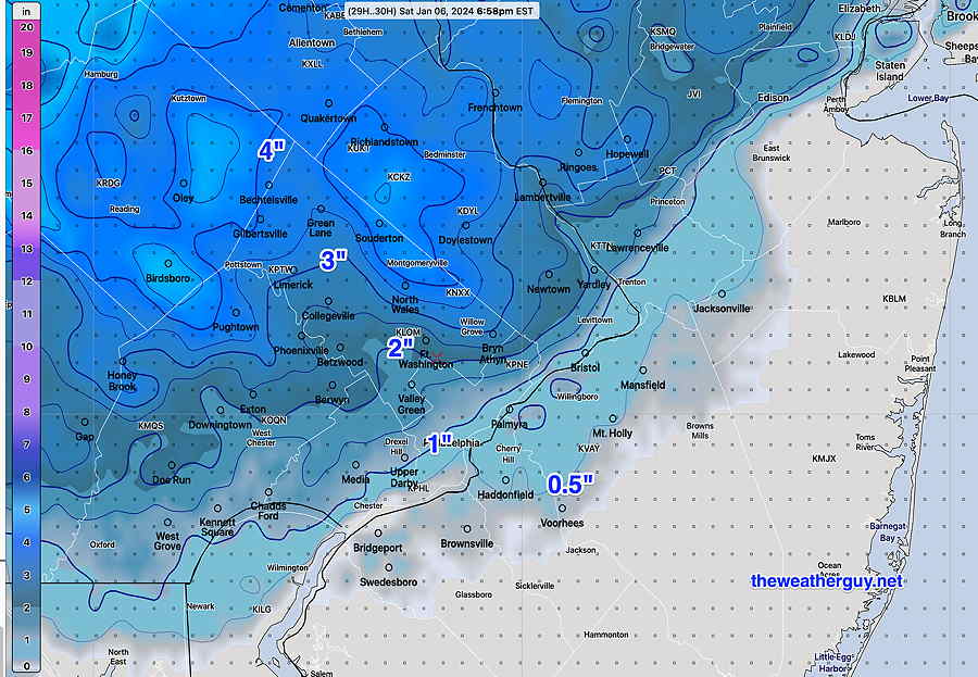
The latest NBM (12z) just became available and I wanted to post it. It shows a slight increase in the snow totals from last night’s run and greater similarity to last night’s NAM—
01-06-24 12z NBM snow totals (Click on image for a larger view.)
I’m going with the NBM forecast snow totals above, but I do want to post the latest Canadian HRDPS, which still is forecasting higher totals—
01-06-24 06z HRDPS forecast snow totals at 6 PM today. The HRDPS has been very good in situations where there’s snow to rain changeovers. I guess we’ll see. (Click on image for a larger view.)
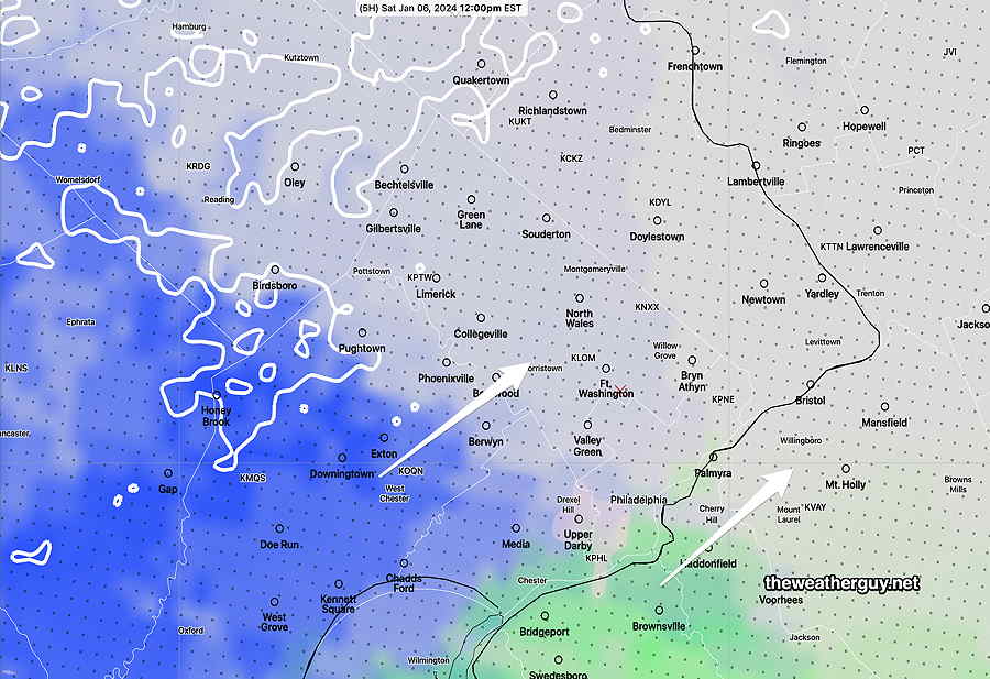
Snow or rain, depending on your location is expected to start around noon to 1 PM, earlier southwest —
01-06-24 12z NBM Precipitation type/probability. Blue is snow green is rain. The transition line is apparent as it moves in. (Click on image for a larger view.)
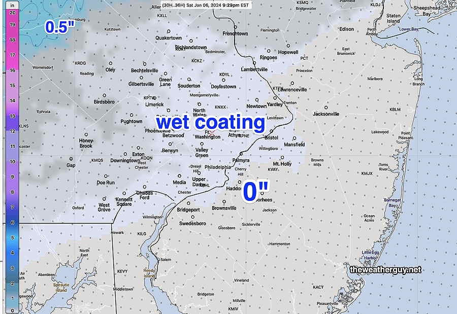
The any snow in the immediate area transitions to all rain 4 PM to 8 PM from southwest to northeast. Tapers to non- accumulating snow flurries and sprinkles Sunday morning
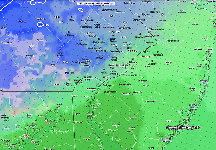
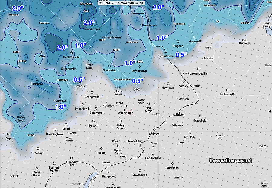
Total Rainfall and combined “snow-water equivalent” near 1 inch or more—
NBM total rainfall +water equuivalent of fallen snow (Click on image for a larger view.)
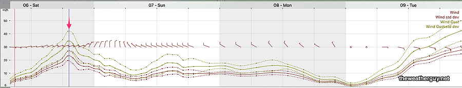
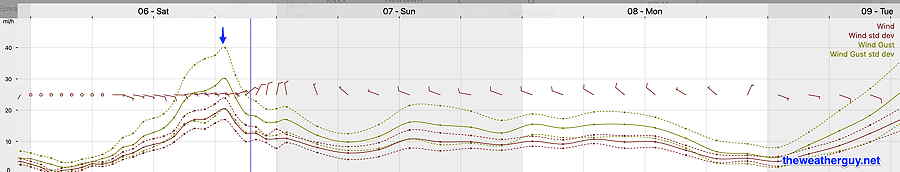
Winds increase Saturday evening—
Updates later this afternoon, between 5 and 6 PM.
Winter Storm Update
Posted Friday 01/05 @ 10:09 PM — One more thing I’ve glossed over… we’re not going to be getting much snow, but the total precipitation will be over an inch of rain or combined snow water equivalent. So whatever snow we get will turn into a heavy rain event with wind gusts Saturday evening.
Posted Friday 01/05 @ 9:09 PM — Tonight’s HRRR continues with a minimal to non-snow event for us and I’m leaning towards that, since it’s backed up by the NBM —
01-06-24 00z HRRR snow totals. Contours are labeled with snow depths. (Click on image for a larger view.)
As pointed out in my earlier post, the Canadian HRDPS was showing somewhat more snow. With my long standing mantra, “Never Ignore the NAM”, I’m posting tonight’s NAM snow forecast for old time’s sake, which is somewhat similar to the HRDPS —
01-06-24 00z NAM Snow forecast through 7 PM Saturday. (Click on image for a larger view.)
Weekend Storm Update
I’ve already committed to a mostly rain event, starting as light snow and changing to rain avoiding accumulations in most areas.
Of interest is the Canadian HRDPS model which maintains a cold lower atmosphere longer as heavy precipitation moves in sooner. The HRDPS is forecasting heavier snow before a later changeover to rain around 5 PM.
Here’s the latest HRDPS snow accumulation max at 7 PM—
01-05-24 18z HRDPS snow totals (Click on image for a larger view.)
I’m just putting this out there because the HRDPS did very well with precipitation types last year. If we get more snow than the NBM and HRRR are forecasting, it won’t be a complete surprise. This is what makes this so interesting.
Posted Friday 01/05 @ 4:48 PM — The forecast continues to change in the direction of a much warmer, inland system for us with late coastal redevelopment off of NJ.
The latest NAM-NEST captures the newer track of the storm, which pushes warm air into our area—
01-05-24 NAM-NEST forecast for 7 PM Saturday has the main low moving up from the southwest over Maryland. The inland track brings even more warm air into the system for us. A secondary low forms off of the NJ coast. Heavy rain now seems likely for eastern NJ. Note that the surface freezing line is way to our north (white contour) and the 540 thickness line (red contour) to our north indicates a warmer atmosphere.
As a result, any snow that develops around noontime will quickly mix with and change to rain by late afternoon and early evening. Any accumulation Saturday afternoon will be reduced considerably by fairly heavy rain Saturday evening. Indeed, it looks like this storm is essentially a rain storm for us.
As the system moves through and the secondary low develops off the coast of NJ, expect some big wind gusts Saturday evening.
NBM winds/wind gusts peak early evening Saturday. (Click on image for a larger view.)
Here’s the latest model blend (NBM) snow totals, a significant change from previous forecasts—
I’m already keeping my eye on the next storm, a rain storm for us, for much of Tuesday.
Weekend Storm Outlook
Previously Posted Fri 10:01 AM —
The development of this approaching storm system has been forecast by the models for almost two weeks and its general evolution so far hasn’t had many surprises. Despite being in a favorable location for heavy snow in our region (in colder ‘normal’ past winters), the lack of deep cold this winter will result in a mixed bag of precipitation types, now mostly rain. The latest model trend is for much less (or no) snow accumulation (see below).
Friday morning, the storm is currently just off the coast of Texas—
The precipitation will reach our area, from southwest to northeast, about noon to 2 PM, somewhat earlier in western Chester county. It will begin as light snow/flurries but will increase in intensity and mix with rain as early 3 PM in many locations that start as snow.
01-05-24 12z NBM Precipitation type at 3 PM. Many locations are all rain or a mix except north and west of the city. (Click on image for a larger view.)
By 10 PM, most areas are just receiving rain with temps in the mid to upper 30s—
01-05-24 12z NBM precip type/ conditional probability at 10 PM. (Click on image for a larger view.)
A change back to some wet snow will occur as some cold air aloft mixes back in as the low pressure depart early morning Sunday.
01-05-24 12z NBM forecast 7 AM Sunday. Mostly light rain, some wet snow mixed in. Temps above freezing here. (Click on image for a larger view.)
Light sprinkles, spotty showers and snow flurries persist until early afternoon. The Eagles will have mostly dry conditions, temps around 37º, not too windy, at game start.
Total snow accumulation forecast continue to diminish to zero in many areas—
Latest 01-05-24 12z HRRR shows virtually no snow for much of the immediate PHL area. (Click on image for a larger view.)
2 thoughts on “WEEKEND WEATHER FORECAST”
I love winter. And part of that is due to this site.
LOL. I’m glad to know my hobby is an enhancement to your winter enjoyment. FYI, this is my favorite type of storm…all the fun of trying to nail down the snow totals without having to deal with much (if any) snow shoveling and plowing afterwards.

I love winter. And part of that is due to this site.
LOL. I’m glad to know my hobby is an enhancement to your winter enjoyment. FYI, this is my favorite type of storm…all the fun of trying to nail down the snow totals without having to deal with much (if any) snow shoveling and plowing afterwards.