
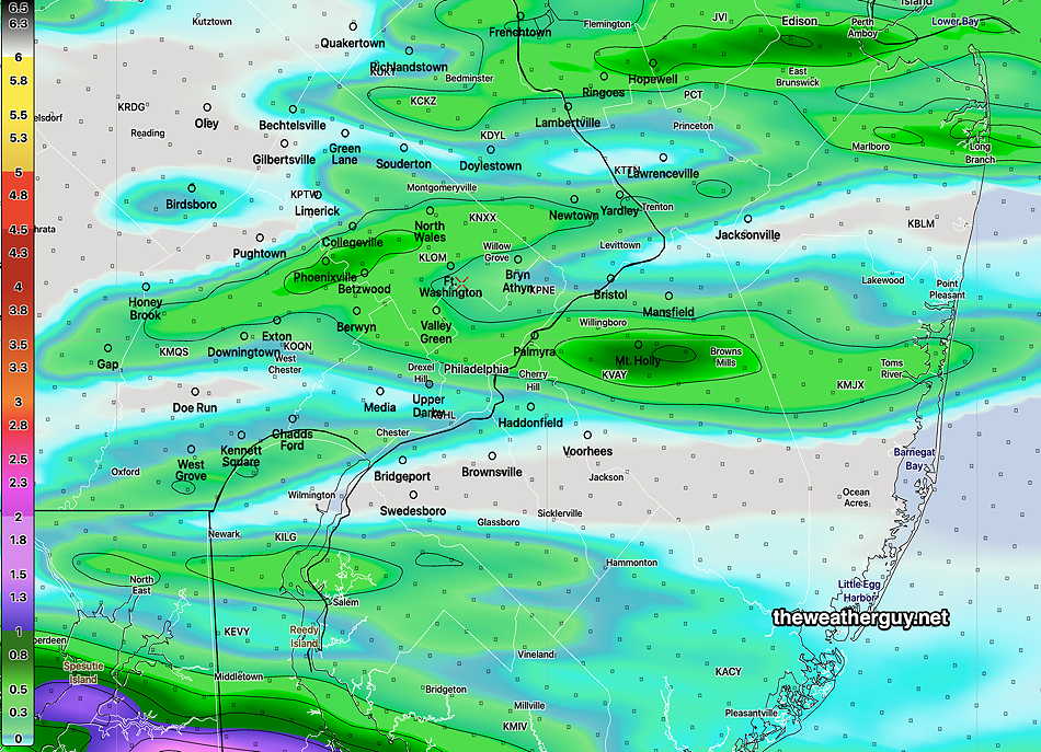
Update Sat 7/29 5:06 PM — A quick mobile update. Based 18z HRRR and current radar/satellite imagery, heaviest activity into NJ and South Jersey. Philadelphia and immediate western suburbs may just get clipped by current track of storms, mostly going eastward.
#Philadelphia #weather #PAwx
Update Sat 7/29 12:40 PM — A quick mobile update. Latest HRRR and HRDPS has the storms between 4:30pm and 6pm. The heaviest activity will move just north and just south of the immediate Philadelphia area. We’ve seen that storm placement often is inexact.
#Philadelphia #weather #PAwx
Updated Sat 07/29 @ 9:17 AM — Yesterday’s HRRR and HRDPS combined yielded the best timing forecast for those storms last night. As always, predicting the precise location of the storm’s path is beyond the capability of today’s numerical weather models. (I provide it only as a guide.)
Kudos to Channel 6’s meteorologist Brittany Boyer for her candid acknowledgement that their previous day’s thunderstorm forecast wasn’t what they had predicted and for directly acknowledging that the models of late haven’t been too accurate with thunderstorm predictions. Intellectual honesty and humility isn’t something you see often with many of the of the other TV weather people. Refreshing!
As for today, the 06z HRRR and 06z HRDPS show thunderstorms moving into the immediate Philadelphia areas and suburbs from the west as early as 3:30 PM to 5 PM. Heaviest activity is currently forecast to our south, in Delaware.
What’ most impressive with today’s severe parameters is elevated helicity and shear. Jet stream winds also higher than previous days.
Those severe parameter mean that storms should stay together and there’s a very slight risk of tornadic activity. Straight line wind gusts of 40+ mph possible.
This morning’s HRRR shows that this system will be faster moving than previously thought.
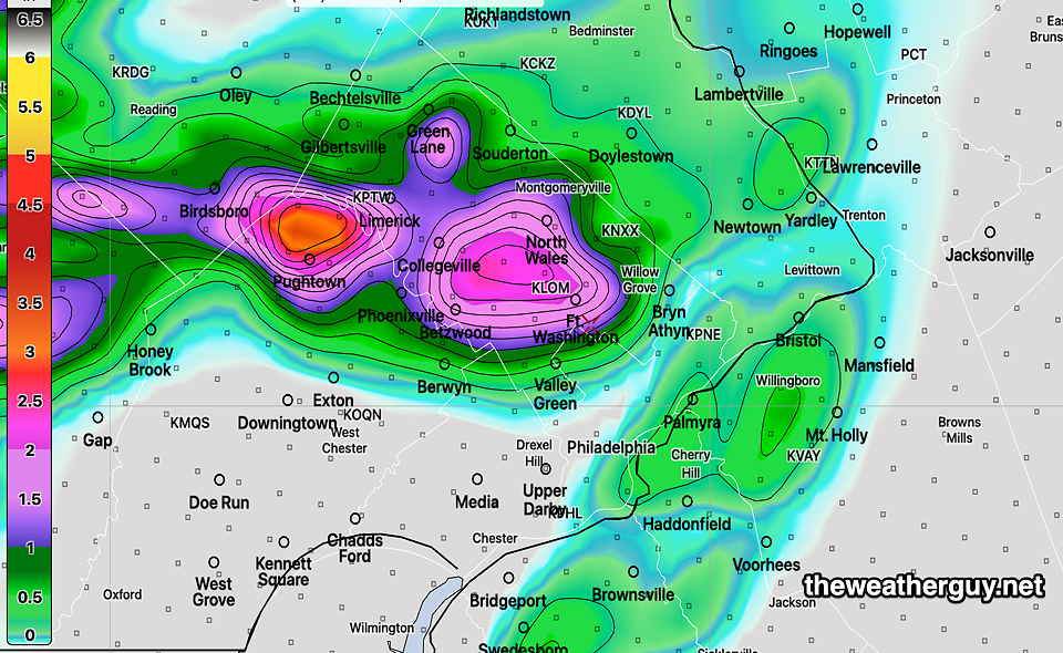
Here’s this morning’s 12z HRRR just available showing the model’s guess of where the heaviest rainfall will be—
Updated Fri 07/28 @ 7:36 PM — Approaching storms at 7:28 PM—

Previously Posted Fri 5:28 PM —
Our first focus will be this evening (Friday), where both the 12z HRDPS and the latest 18z HRRR show an upper disturbance setting off thunderstorms between 9 PM and 1 AM tonight, mostly just north and west of Philadelphia.
With PWATs in the 2.1″ range, the HRRR is cranking out some locally heavy rain this evening in some areas—
Saturday
The disturbance affecting us Friday evening may linger into early Saturday morning with additional widely scattered showers. Sunshine expected by mid to late morning. Saturday will be hot and very humid. While temperatures will be a bit lower than Friday, humidity levels are expected to be much higher.
An approaching cold front will bring an increasing chance of thunderstorms later Saturday afternoon. The models show this front coming through slowly and the initial batch of showers may go to our north and our south. Additional showers and thunderstorms as late as midnight and 1 AM Sunday morning.
High temperature 92.1º sd 2.0º ( NBM model— location Blue Bell, PA)
Sunday
There’s some uncertainty with Sunday’s forecast. Some models have some widely scattered showers around as the front will linger somewhat near us. The general headline is sunny and cooler, but it may not be that simple.
We’ll go with some lingering clouds possible in the early morning, then sunshine. But don’t be surprised if there’s a slight forecast change. It will be less hot and less humid.
High temperature 83.8º sd 3.0º ( NBM model— location Blue Bell, PA Note that the high sd of 3.0º reflects some of the uncertainty. )