Happy New Year!
Update Sat @ 10:11 PM — It hasn’t gone unnoticed that the TV/radio weather people haven’t really mentioned anything about the snow possibility for our region on Monday morning. I’m truly perplexed by it. But I guess that’s why you’re here reading this blog.
I must mention that the NAM, NAM NEST and ICON models have shown zero snow until this evening. ( They now show snow in southern NJ only.) Very strange to have such a wide divergence of forecasts.
Here’s tonight’s HRRR model, which continues to show snow, as does the NBM and the SREF.
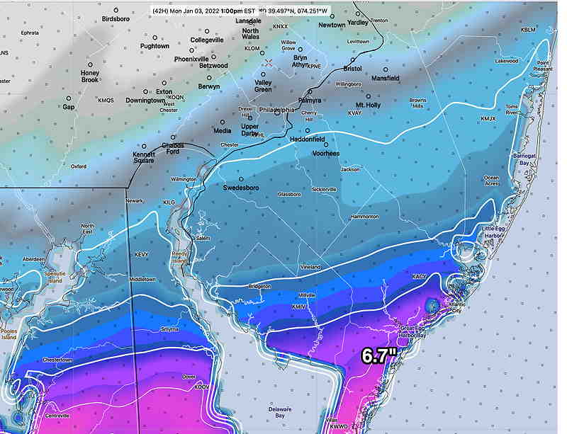
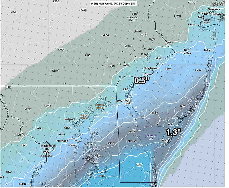

With all these models, the most likely forecast is snow in Southern New Jersey and a rapid taper to zero just west of the city. The surprise would be if the SREF just above is correct.
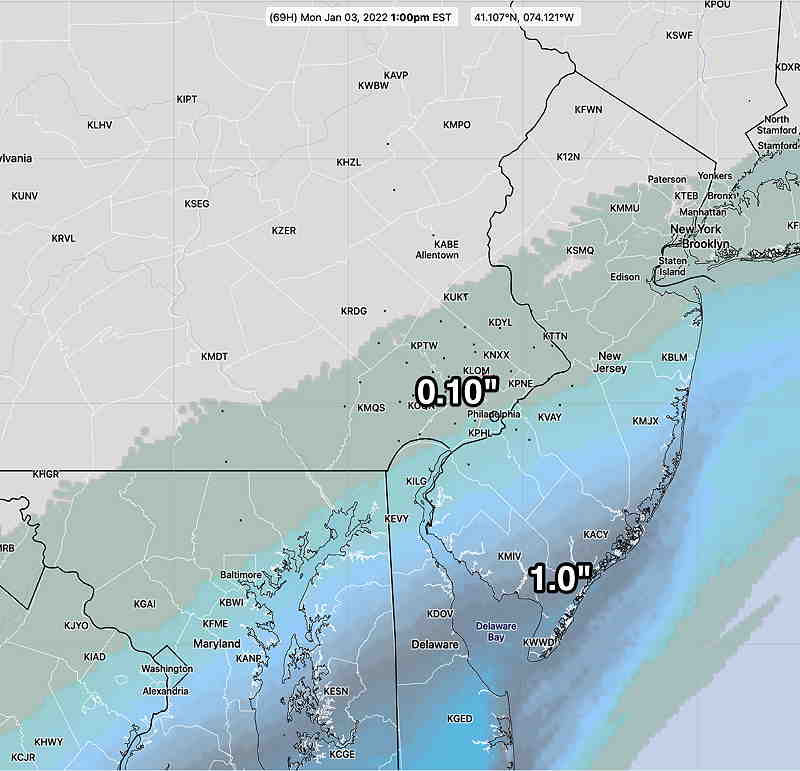
Update Sat @ 4:18 PM — I have more interesting data to share and chew on regarding snow early Monday. The most recent run of the HRRR (which forecasts out 48 hours) has more than moved in the direction of the GFS regarding possible snowfall for Monday. Here’s the latest HRRR snow totals for Monday morning—
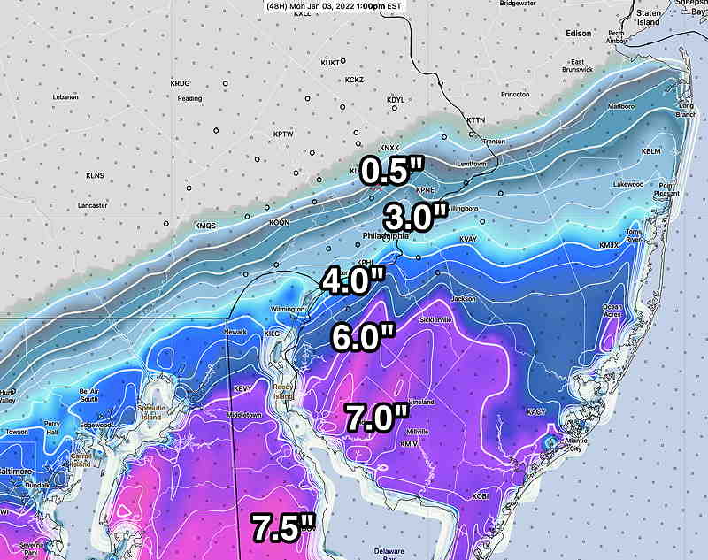
Several models, including the Canadian GEM, the Canadian GEPS and the ICON Ensemble (ICON-EPS) have moved in the direction of the GFS with accumulating snow, especially for South Jersey. Their snow totals have a similar profile, decreasing towards Philadelphia, with maximum snow of 2.0 inches in Cape May County.
The possibility of snow has been a ongoing possibility since since I mentioned it in Tuesday’s blog post. It’s been on again, off again. The above HRRR is the latest, possibly the most extreme possibility.
If you’re just joining this this blog forecast discussion, I recommend you read the background info below.
Stay tuned.
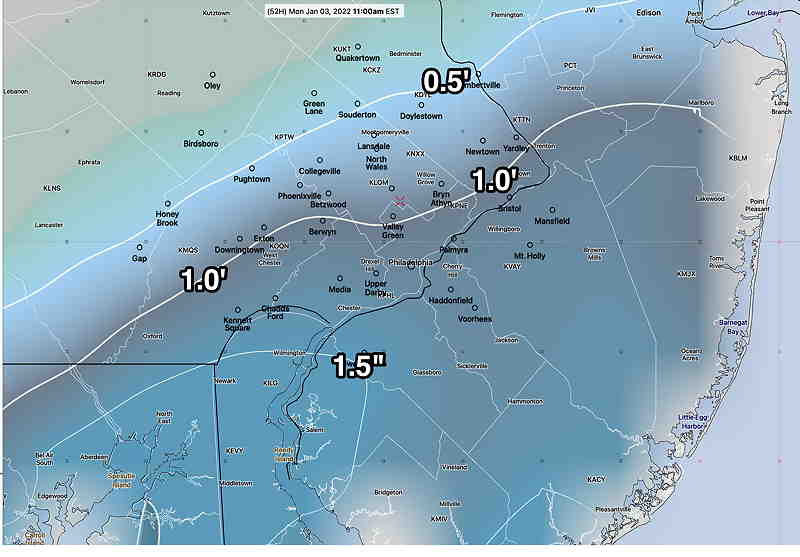
Update Sat @ 11:10 AM — The latest GFS model just became available minutes ago. Hard to believe (literally), but here’s the snow the GFS is predicting by Monday morning. I’m just throwing this out there —
Update Sat @ 9:58 AM — The period between Sunday and Monday is just coming into range of the higher resolution short range models.
Saturday —rainy and mild.
Sunday- Cloudy with a thinner cloud deck into the afternoon. Very mild until the front moves through.
The front moves through between 3 and 5 PM. Gusty winds with highly scattered light sprinkles as temps begin to drop.
Despite last night’s GFS model’s snow prediction, the other models all keep any precipitation to our to our far south and east. Even the NBM has removed snow from its forecast. So no snow late Sunday night into Monday.
Updated Sat @ 8:10 AM — No significant change in Saturday’s forecast. The spotty light rain drizzle in the morning today will become more steady by the afternoon.
The trend for late Sunday is for any measurable snow to be in Delaware and southern NJ (Cape May).
The GFS still has measurable snow here by Monday morning. The higher resolution short range models have no snow in our neck of the woods. The GFS ensemble still shows light precipitation falling as snow before daybreak south and east of the city, but no accumulation around PHL. (As was the case last week, the GFS over-predicted snow here. I’m going to lean away from the GFS this time around.)
Previously Posted Fri 6:10 PM —
The mild weather continues through Sunday. A continuing complex scenario is expected play out Sunday into Monday as a cold front approaches from the west and low pressure develops as it stalls.
Saturday
Low pressure to our southwest will sweep another warm front through Saturday. Saturday will be rainy during the day and evening through midnight. There may be some pauses in the action, but a rainy day expected. High temp 59º ± 3.0º
Sunday
The advancing cold front approaches during the day. Showers in the morning, then mostly cloudy until late afternoon (~4 PM), when the actual cold front moves through and additional showers develop. Becoming WINDY. Additional showers during the evening. High temp 59.5º ± 5º (high spread/high uncertainty!) NBM model Blue Bell.
I’ve been focusing on the Sunday evening period since Tuesday’s blog post and and it’s been on again off again regarding low pressure development. A new wrinkle has developed with today’s models—
The cold front appears to stall late Sunday night into Monday morning. Yet another low pressure system develops before daybreak Monday to our south. The precipitation shield appears to expand enough to cover our area with light snow.
The GFS and the ensembles (GEFS and SREF) show a light snow shield over us early Monday morning. Totals appear to be less than 0.5″ near Cape May NJ.
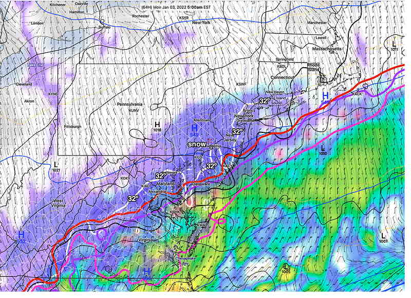
The GFS has light snow only from 4-8 AM with just coating amounts in the immediate PHL area. The ensemble forecasts continue the possibility of light snow later into the morning with additional weak waves on the front.
This continues to be a complex scenario and a low confidence forecast. I’ll keep an eye on this. Stay tuned.
