
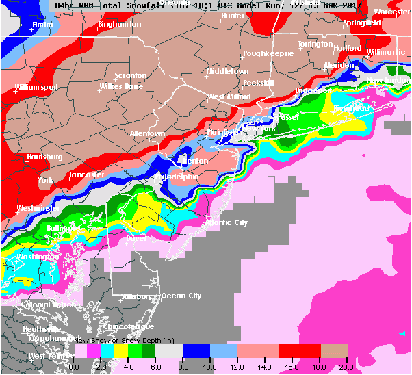
Mon 11:15AM update: Latest NAM model output has increased the QPF further to over 1.70 inches water!
Other complication is the influx of warm air in the upper atmosphere, which suggests a changeover to sleet and freezing rain for several hours around daybreak and into the morning in Philadelphia, which will reduce accumulations . If this is all snow, the expected snowfall is now around 15-20 inches, but if there is the changeover to sleet, 10-12 is a good guess in Philadelphia.
[stbpro id=”alert” caption=”Current Snowstorm Predictions 11:15 AM”]In Philadelphia 10-12 inches, areas outside the city (northwest suburbs) 15-20 inches[/stbpro]
Last night’s 2AM runs of the NAM and GFS models were remarkably similar and it’s rare to see such similarity about an upcoming storm. This means there’s an extremely high confidence in the severity of this storm.
QPF values have significantly increased with the NAM having about 1.55 inches water and the the GFS having 1.64 inches water.
The key features: Both models have a period of warmer air intruding at the upper levels of the atmosphere between 6 AM and 10 AM, while the lower levels are just at or below freezing.
This might allow a period of freezing rain and sleet to develop for that time period, reducing snow totals due to compaction. Total snowfall totals, extremely difficult to estimate, but best guess is 10-15 inches, depending upon how long the period of sleet/freezing rain lasts.
Areas outside of PHL and its immediate counties to the north and west will have less sleet and rain and potentially 17-18 inches.
Both models show a return to all snow, heavy at times, before tapering and ending in the early to mid afternoon. This will likely be a heavy, wet snow with high winds, possibly causing power failures.
I’ll update early afternoon if things change considerably. Count on an update about 10:30 PM tonight.