Update Thu @ 8:09 PM — Previous posts have indicated a warmup for the weekend as the jet flow becomes ridge-like over our area. The southwesterly flow will also bring moisture to our area in the form of clouds and some showers. There’s also the possibility of heavier rain next week.
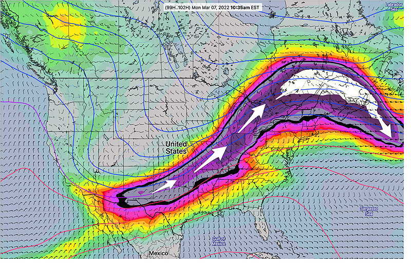
GEFS (mode) jet stream wind forecast (250mb) for Monday morning showing ridge over northeast. The white area is referred to as a “jet streak”, an area of increased wind speed, this case approaching 198 mph. Rising and falling motions (rain) occur at certain areas of the jet streak. (Click on image for a larger view.)
For Saturday, a warm front is expected to move through our area with significant cloudiness for much of the day. No rain expected.
For Sunday, there has been recent uncertainty regarding the speed and placement of showers on Sunday far ahead of a frontal system.
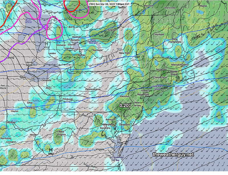
The ECMWF has been forecasting a period of rain Sunday morning with partial clearing in the later afternoon. It’s forecasting about 0.20 inches of rain.
Today’s 12z ECMWF showing 3 hour rain accumulation at 1 PM Sunday. (Click on image for a larger view.)
The GFS has only a very light shower (< 0.02 inches) and mostly for areas north of the immediate Philadelphia area.
But today’s ICON and Canadian models have joined the ECMWF with the period of light rain in the morning. The NAM has also joined that group.
While ECMWF model is new to me (a limited but substantially increased data set only recently became available to the general public this past January 2022), I’m first learning its biases and tendencies and how to integrate its forecasts with the other main weather models like the GFS and NAM. As recently as last week though, a similar difference between the ECMWF and the GFS turned out in favor of the ECMWF forecast.
So with the ICON and Canadian RGEM leaning towards somewhat more rain, I’m leaning in that direction for Sunday. Most models have clouds thinning in the afternoon with temps in the 60s and WINDY conditions, although the latest GFS maintains a fair amount of cloudiness even in the afternoon.
Update Wed @ 10:30 PM — With the warming pattern expected this weekend, today’s models have quite a wide range of forecasts. There’s pretty good agreement for mostly cloudy conditions on Saturday, but not much agreement about whether we get rain on Sunday. The ECMWF and the GEFS show rain, the operational GFS, ICON and Canadian Global not so much. Too soon to know.
Update Tue @ 7:45 PM — Looking at today’s models, the warmup promised from a pattern transition to an upper air ridge still looks on track for the weekend.
Some showers possible late Wednesday night into Thursday morning, especially northern suburbs.
Saturday will be milder but may have considerable cloudiness. There’s a chance of sprinkles far north and west.
Sunday will be mild but some rain is likely.
That upper air ridge may be persistent with milder temps next week but several chances of rain.
Previously Posted Mon 4:59 PM —
It appears that we will have a quiet weather pattern this coming week.
The jet flow is expected to transition from the current colder trough pattern over the east —
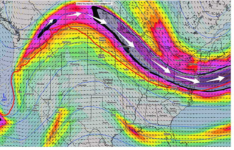
ECMWF forecast jet stream winds (300 mb level) for Thursday at 1 PM. A trough over the northeast with cold air. (Click on image for a larger view.)
to a ridge over the east by the weekend with warmer temperatures—
ECMWF jet stream forecast (300 mb winds) for Saturday at 7 PM. An upper ridge is expected to develop over the northeast. (Click on image for a larger view.)
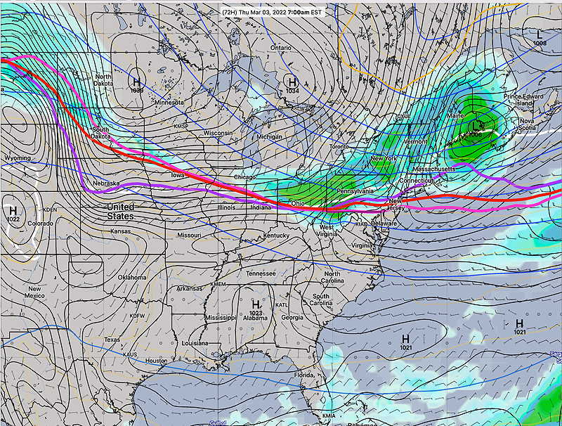
During the week, several disturbances will pass by to our north, bringing some clouds and weak fronts. Here’s Thursday morning—
Today’s GEFS forecast for Thursday, showing some light rain barely making into our area, with the system passing to our north. (Click on image for a larger view.)
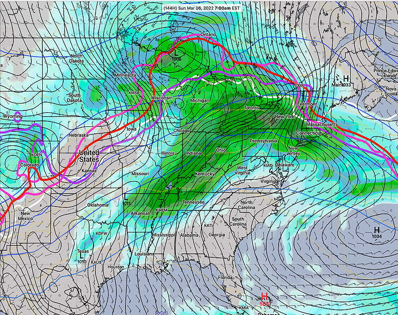
By the weekend the upper flow from the southwest will bring milder temperatures, but also considerable moisture and clouds, and possibly rain by Sunday.
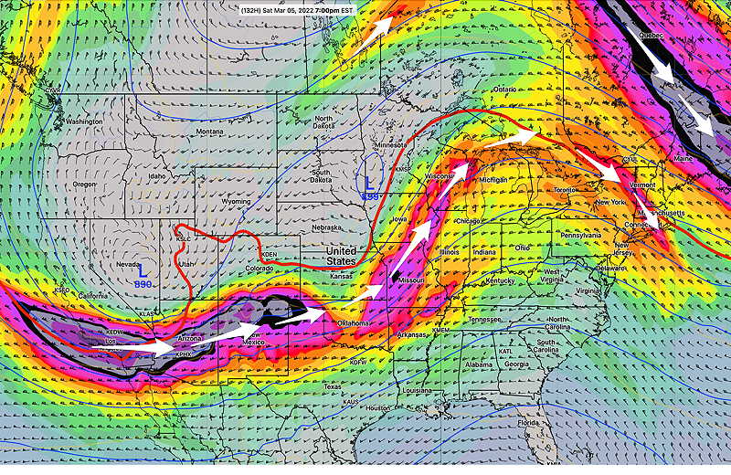
GEFS forecast for Sunday at 7 PM. There is some uncertainty about the timing of this system moving through. (Click on image for a larger view.)