
#Philadelphia #weather #PAwx
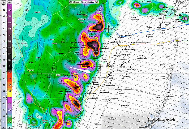
Posted Thu, 08/29/24 @ 7:44 PM— Clouds moved back in Thursday afternoon and low level cloudiness is expected for much of Friday. Showers and storms in central PA this evening are again having trouble moving into the Philadelphia area intact.
The models (again with the exception of the ECMWF) have some light showers making into the immediate PHL area in the predawn hours Friday. Any rainfall here will be light.
Low clouds and even some drizzle is expected on Friday with an easterly wind providing the moisture. Some additional showers may pop up Friday afternoon due to moisture convergence.
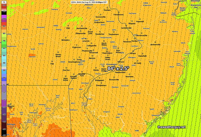
Saturday is looking fairly cloudy, except at the shore. A cold front moves through with showers and storms Saturday night and some showers will linger into Sunday, especially in NJ.
Sunshine for Monday, but some high clouds may linger at the shore due to a low pressure system developing on the front to our south.
The model forecasts haven’t been too stellar this week. My guess is that changes in the Labor Day Weekend Forecast are likely.
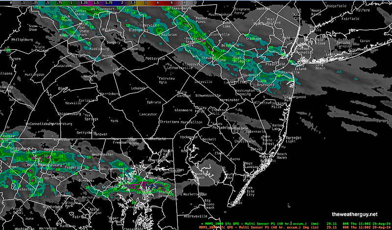
The expected complex of storms expected to move just near Philadelphia at 3 AM didn’t materialize. Numerous models got this wrong, with the notable exception of the ECMWF.
Many parts of our area haven’t had very much rainfall in weeks. The forecast for tonight (Thursday night) into Friday is for significant rainfall in the Delaware Valley and the ECMWF is currently on board with this forecast.
Thunderstorm Possibility
Posted Wednesday 08/28/24 @ 7:43 PM — So far, our area hasn’t seen any scattered storms. The current water vapor and radar shows storms developing to our north and southwest at 7:30PM—
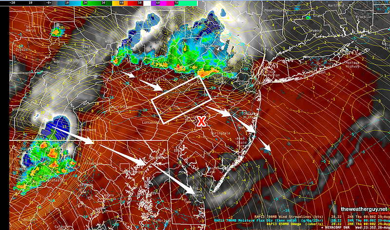
The afternoon models have storms to our north and just to our south about 9-10 PM. I can see why. Nonetheless, there’s an area of strong vertical motion to our immediate northwest and it might lend a hand to some storm activity in our immediate area.
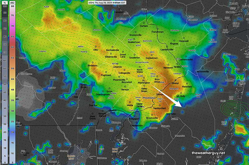
The models continue to have another batch of storms move through between 2AM and 6 AM, although the intensity expected has diminished from previous model runs.
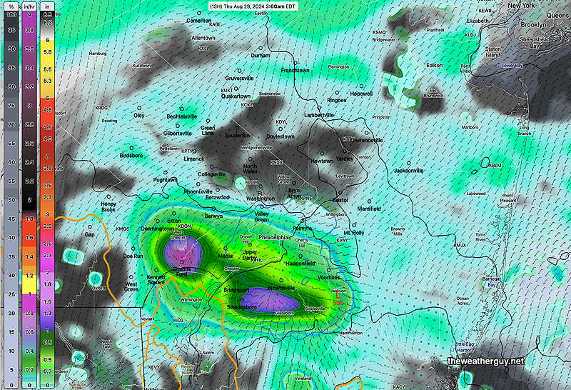
Here’s the experimental RRFS forecast for 3 AM—
While some rain is possible in most areas, only a few areas will have much needed heavier rainfall.
Wednesday Forecast Update
Posted Wednesday 08/28/24 @ 9:45 AM — The thunderstorm and rain forecast for today remains below average confidence. The ECMWF continues to forecast minimal rainfall for the Philadelphia area.
Our NOAA models and the Canadian models had been forecasting a main group of storms moving through about 2-4 AM Thursday, with earlier scattered activity during the evening.
However the latest 12z HRRR just became available and it shows minimal rainfall and highly scattered activity. The experimental 00z and 06z RRFS continues to show a heavy group of storms moving through 2-4AM, but the 12z RRFS is not yet available.
So the trend is for minimal rainfall in the immediate Philadelphia area, a big shift from what was forecast yesterday and closer to the ECMWF. As mentioned in several previous updates this week, the models have been unusually inconsistent.
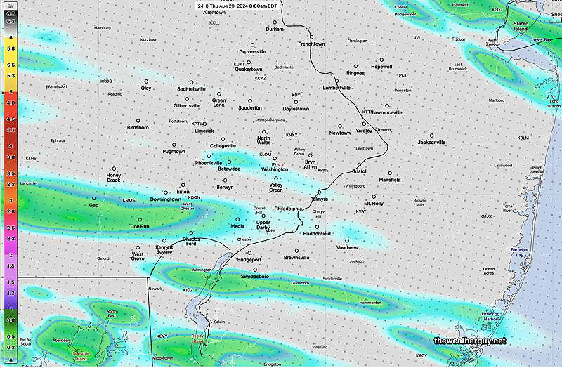
Here’s the latest HRRR total rainfall through 8 AM Thursday. The HRRR has all of this falling after midnight tonight —
Wednesday Forecast Update
Posted Tuesday 08/27/24 @ 5:29 PM — There continues to be large model differences in the forecast of showers and thunderstorms Wednesday late afternoon and Wednesday night. As a result, this is a low confidence forecast.
Basically, temperatures are still expected to reach 96º-97º or so, according to the latest NBM.
The big question is the timing and coverage of any showers and storms. The models have lacked continuity between themselves and their own previous runs.
Some models have storms developing and moving through late afternoon 4- 6 PM, mostly scattered. The HRRR and RRFS both have a large complex of storms moving through between 2 AM and 6 AM Thursday morning. The ECMWF showed this earlier, but the latest run has much of the rain skipping over the city.
The latest HREF and Canadian RGEM just available perhaps has the best compromise. Scattered storms starting as early as 4 PM, and scattered storms through the evening. Then a large complex of strong storms moves through 2-6 AM Thursday morning.
Here’s the current HRRR forecast for 5 AM Thursday —
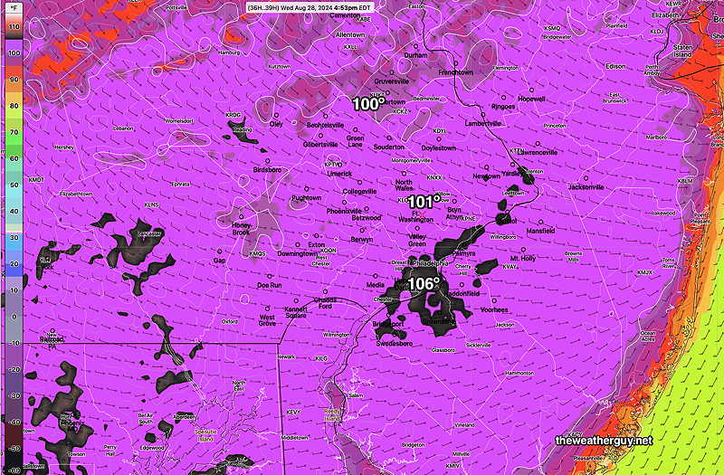
Wednesday Heat Update
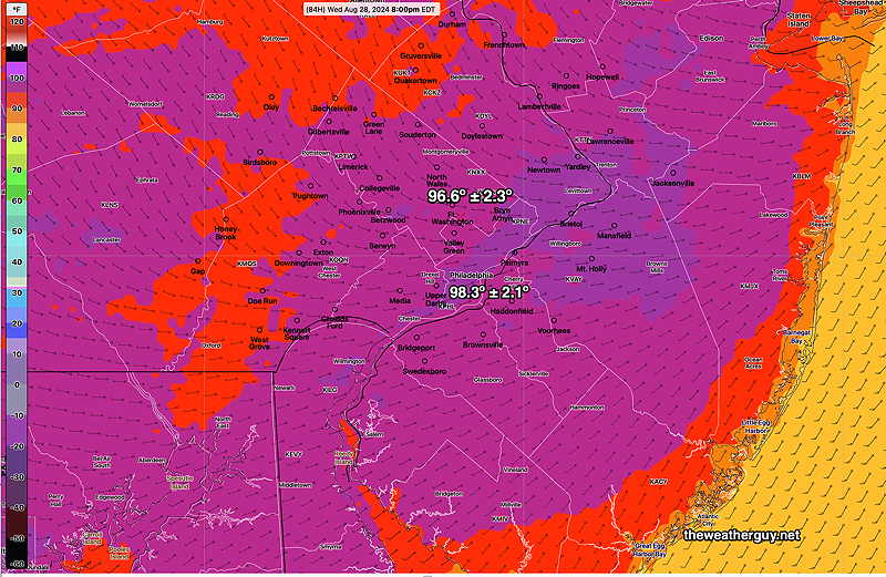
Posted Tuesday 08/27/24 @ 8:43 AM — The forecast continues to evolve for this week and the weekend. Wednesday continues to be a very hot day with high temperatures 96º (Blue Bell) -97º (Philadelphia). Dew points will be in the humid 70s and the heat indices will be over a 100º—
Here’s the NBM heat indices in the late afternoon Wednesday—
Regarding potential rainfall, the forecast seems to change from day to day.
Last night’s models now have some heavy thunderstorms moving through the immediate Philadelphia area late Wednesday evening and into the after-midnight hours of Thursday. A significant short wave is expected to provide the energy for the showers—
The location and timing of the above is currently supported by the ECMWF model, but again, there’s been changes in this forecast almost daily.
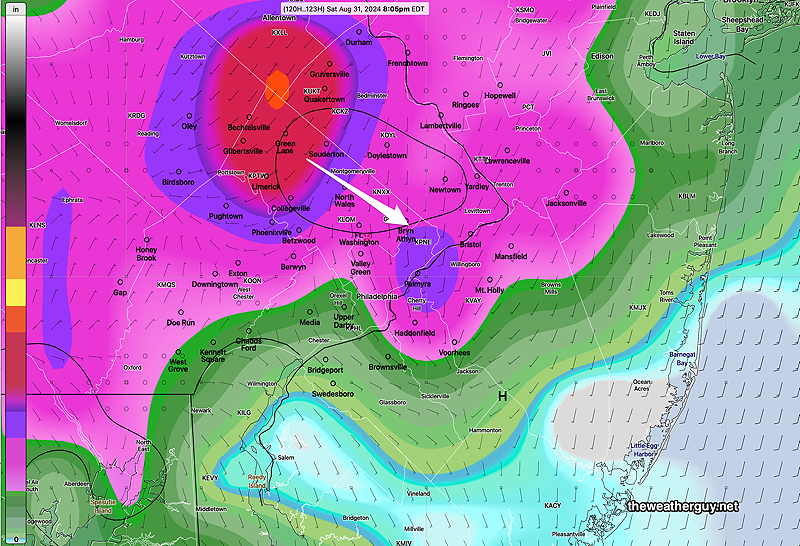
The ECMWF also shows more thunderstorms moving through Saturday evening—
There’s uncertainty with the rest of the Labor Day Weekend forecast. The front was originally expected to move way to our south, but may get hung up closer to us. A cool trend that looked almost certain for next week is not a certainty now.
Forecast Update
Posted Mon, 08/26/24 @ 7:22 PM— There’s been a few forecast changes since yesterday. High temperatures Wednesday will be somewhat lower than forecast yesterday, with highs 95º-96º. Dew points will be in the low 70s and the heat index will be over 100º.
For those waiting for some decent rainfall, it now looks like it won’t happen late Wednesday through Thursday. It looks like the bulk of the rainfall stays west of the city. Some showers are possible here, but total rainfall looks to be less than 0.25″.
The Labor Day Weekend looks to be unsettled for Saturday and first half of Sunday. Plenty of clouds with some showers possible. I expect this forecast to change.
This Week and Labor Day Weekend Weather
Originally Posted Sun @ 5:28 PM — —The cool weather we’ve been having for the past week will be replaced by possible record high temperatures Wednesday. The edge of the ‘heat dome’, which has been far south of our area, will move north of us by Tuesday into Wednesday.
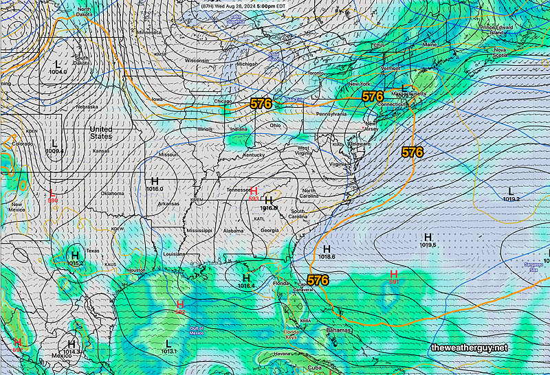
Regular visitors to this site know I use the 576 thickness line (500-1000mb thickness) to demarcate the edge of the heat dome. It’s visible north of us by Wednesday—
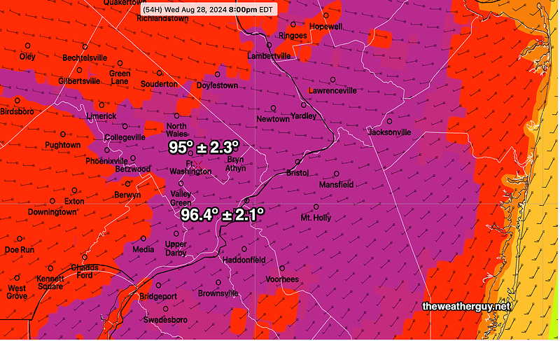
The NBM forecast high temperatures are in the mid to upper 90s on Wednesday!
By Saturday a series of cold fronts will have moved through, the heat ( and the 576 thickness line) will be well to our south, and we’ll be returning to closer to ‘normal’ temperatures here —
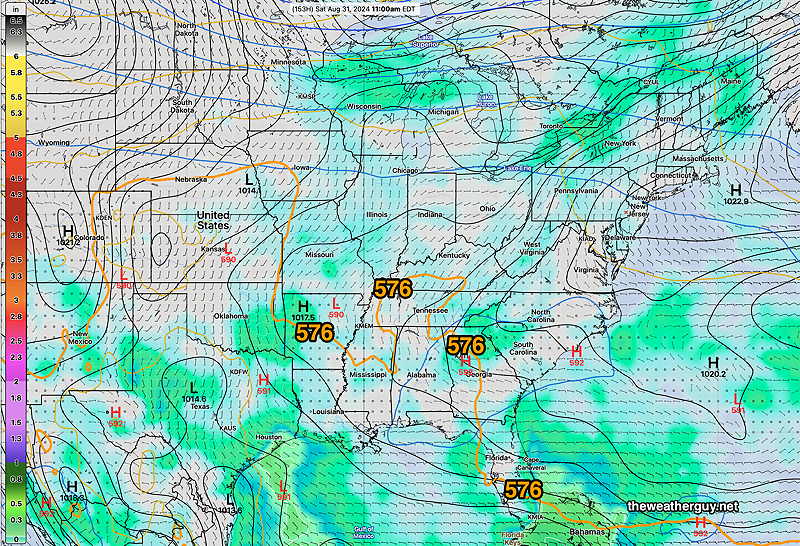
Next Saturday—
A series of fronts may provide some light but much needed rain, possibly Monday night for southern parts of our area and again Wednesday night into Thursday morning. The rainfall late Wednesday night could be more substantial.
There is some uncertainty regarding the southward push of the cold front for next weekend. The front may stall to our south, with showers and thunderstorms for our area. The NAEFS forecast for Saturday above assumes a better weekend. This morning’s GFS has the front stalled to our south. Too soon to know for sure.