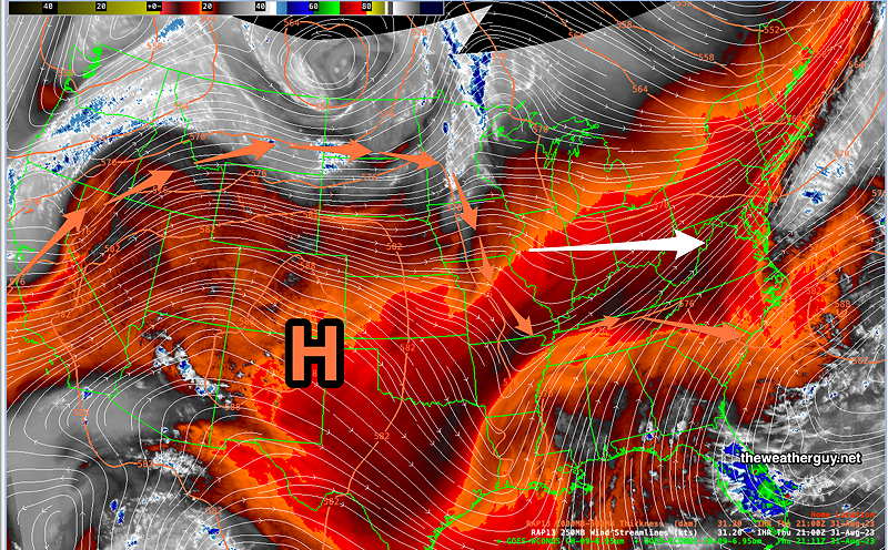
Updated Thu 08/31 @ 5:25 PM — The strong upper level ridge (H) centered over New Mexico and Texas this afternoon will continue to expand northward and eastward through at least Monday—
Current Water Vapor Satellite Image with superimposed RAP model windstreams and 500-1000mb thickness (orange contours/orange arrows) will expand eastward and northward, giving us increasingly warm to hot weather by Sunday. (Click on image for a larger view.)
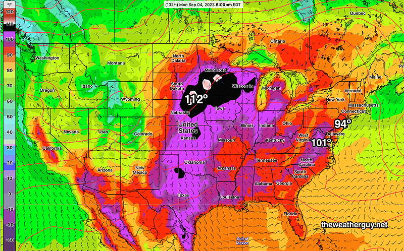
By Labor Day, the NAEFS continues to forecast extraordinarily high temperatures for the beginning of September—
NAEFS forecast high temperature for Monday, Labor Day. (Click on image for a larger view.)
Luckily, dew points won’t be too bad, probably only in the mid 60s at the hottest point in the day.
There will likely be no rain until next Thursday!
Thursday and Weekend Outlook
Updated Wed 08/30 @ 7:55 PM —Beautiful, dry and increasingly warm [hot] weather is in store for us over the next several days.
The high cirrus cloud shield noticeable today will be with us again Thursday morning, which is the outflow moisture from the remnants of Hurricane Idalia. This will move eastward and blue skies are expected Thursday afternoon.
Sunny with increasingly warmer temperatures Friday and Saturday.
A strong upper level ridge of high pressure (another ‘heat dome’) will be developing in the middle of the country and moving eastward. By Sunday, we’ll have above average temperatures approaching 90º.
By Monday, things get seriously hot—
Todays’s 12z NAEFS shows high temperatures by Monday to be more like July than September. (Click on image for a larger view.)
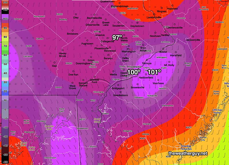
By Tuesday, rather extreme high temperatures for September are possible here—
NAEFS high temperature forecast for next Tuesday! (Click on image for a larger view.)
There’s not likely to be much if any rain over the next 7 days.
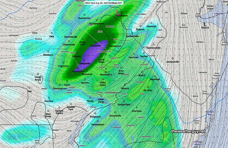
Updated Tue 08/29 @ 9:06 PM — A cold front will move through between 4 AM and 7 AM Wednesday morning with showers. The GFS has dialed back the rainfall considerably with this frontal passage. Skies will clear for sunshine about 10 AM.
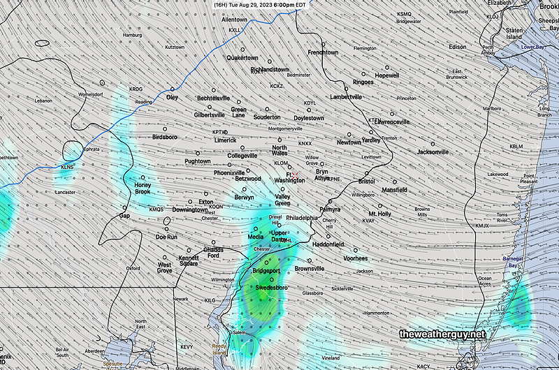
18zHRDPS 1 hour rainfall at 6 AM Wednesday. (Click on image for a larger view.)
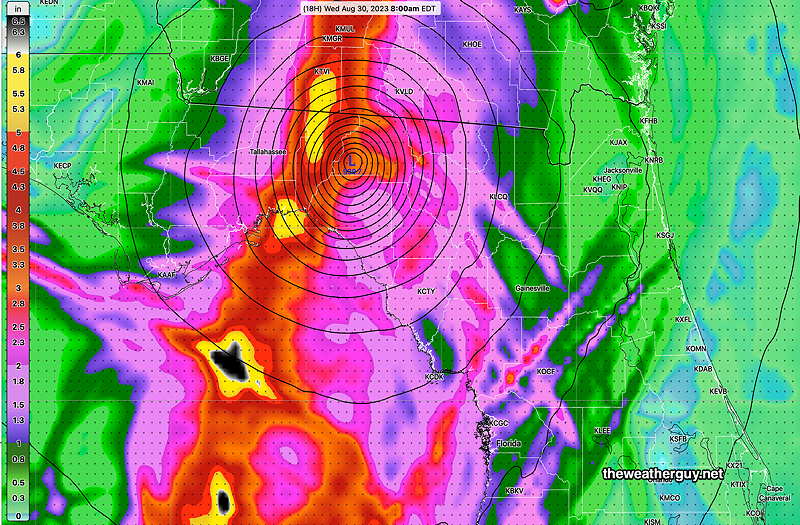
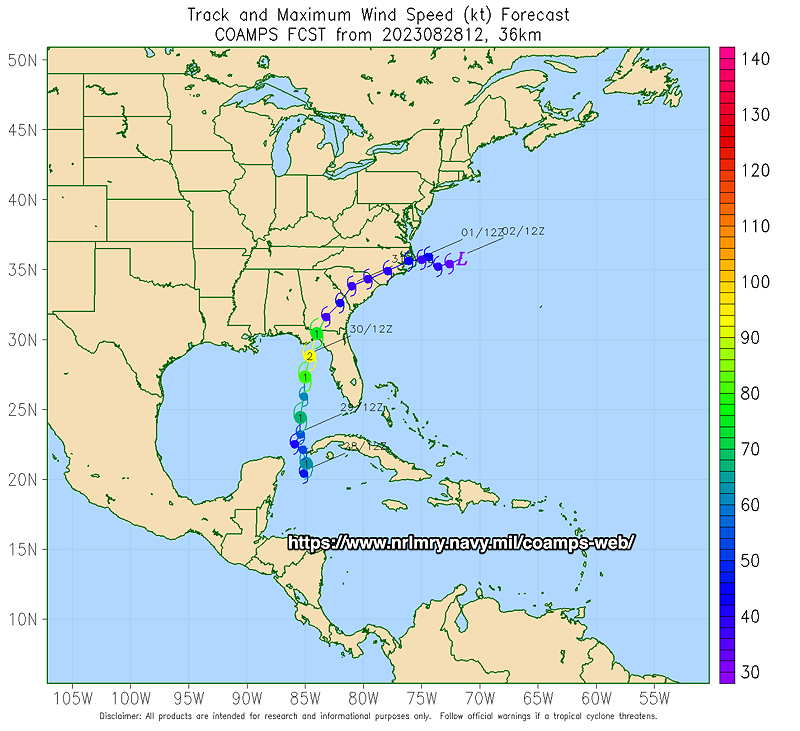
As for Hurricane Idalia, it seems to be speeding up yet still intensifying. Here’s the latest Hurricane HWRF model forecast at 8 AM—
18z HWRF model forecast at 8 AM Wednesday with accumulated rainfall. (Click on image for a larger view.)
Tuesday Forecast Update
Updated Tue 08/29 @ 8:34 AM — I’m updating my Tuesday forecast to be cloudy AND with a chance of a few showers in the afternoon, mostly between 2 and 6 PM. Most areas will not see showers this afternoon.
06z HRDPS forecast showing the total rainfall from showers by 6PM today. Most areas just cloudy. (Click on image for a larger view.)
The main line of showers with the cold front moves through about 4-5 AM Wednesday morning. Clearing with sunshine expected by mid to late morning on Wednesday.
Tuesday Forecast
Updated Mon 08/28 @ 8:21 PM — It looked like it might rain all day today, but the models kept us dry and such was the case.
Tuesday is looking even cloudier and more muggy than today. A few scattered showers before daybreak, but most of the day expected to be very cloudy with little to no rain. There will be a noticeable increase in humidity, some of it directly coming from the outflow of Hurricane Franklin.
An approaching cold front will bring a gradually increasing chance of showers late Tuesday afternoon. Increasing chances by 11 PM to midnight, with showers and thunderstorms expected after midnight into 4 or 5 AM. Clearing Wednesday morning.
All model forecasts keep tropical storm/Hurricane Idalia to our southeast with no direct effects. However tropical systems play havoc with model forecasts. The latest GFS suggests some lingering showers along the Jersey shore on Wednesday.
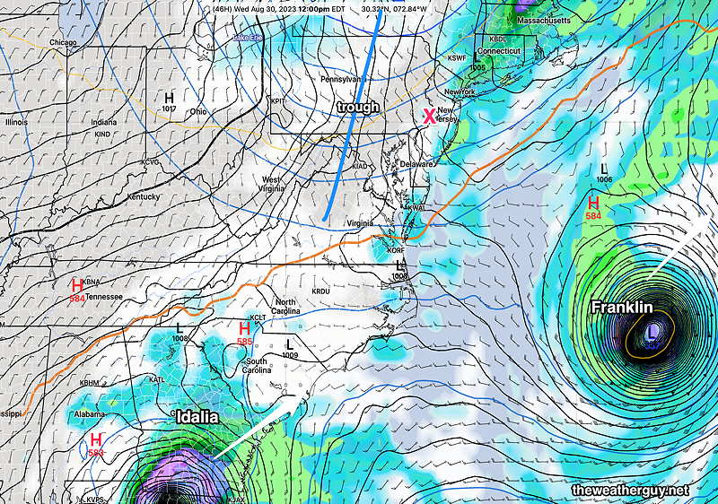
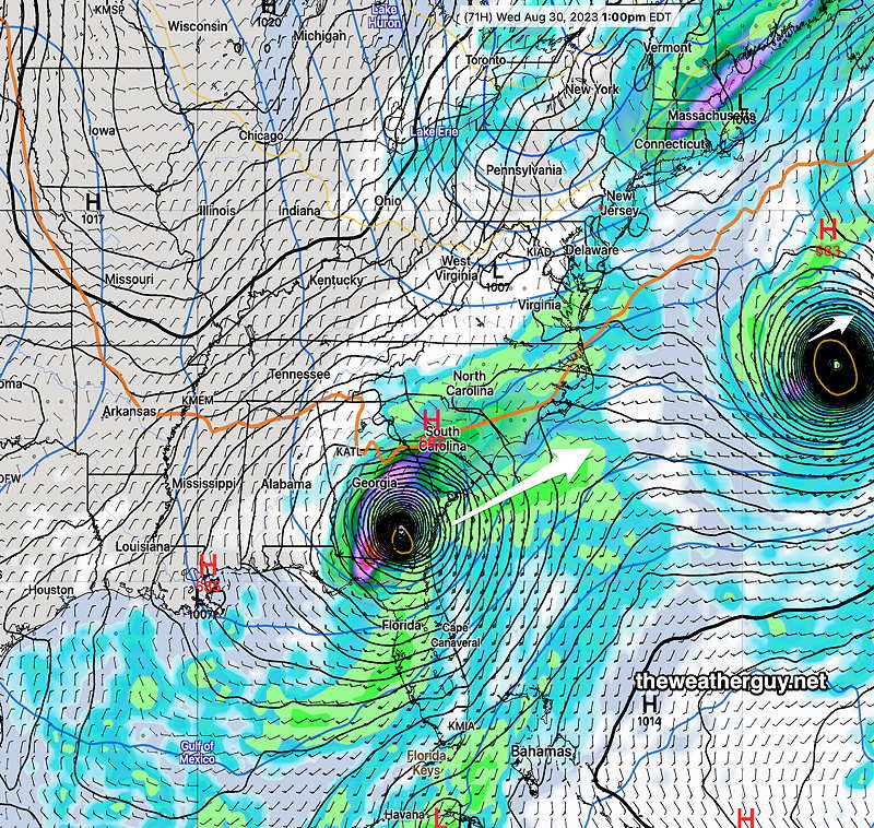
Today’s 18z GFS forecast for 12 noon Wednesday shows Hurricane Franklin and the tropical storm remnants of Hurricane Idalia. The mid level trough (blue line) will keep the storms from advancing to our area. The storm tracks will likely remain parallel to the 576 thickness line (wavy orange line) (Click on image for a larger view.)
Previously Posted Sun 7:58 PM —
A few days ago, it looked like our weather might be affected, at least indirectly, by two hurricanes. Both systems are now forecast to move far off to our east and south by Wednesday.
Latest GFS forecast (18z) showing both tropical systems at 1 PM Wednesday. (Click on image for a larger view.)
While we will escape most of the direct effects of this storms, an easterly flow will keep things cool and cloudy on Monday and the outflow moisture from Franklin in combination with an upper air trough will bring a chance of rain on Tuesday.