
Here’s the very latest weather model data about the Philly snowstorm. The morning’s NAM data just became available. It shows a QPF of 1.35 inches water falling as snow between 7AM and 7PM.
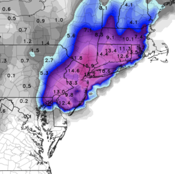
Here’s the latest NAM 10:1 snow totals map. (Important- this map shows additional snow totals that need to be added to any snow that has already accumulated by 7 AM this morning.)
Temperatures are expected to fall to 32-33 as precipitation rates increase during the late morning and early afternoon. Expect heavy snow at times. Temperatures may rise at the end of the storm to 34!
In my neck of the woods, we’re already seeing the difficulties of predicting snow totals for a March snowstorm. Some surfaces and sidewalks have little accumulation, while our wood deck has about 2 inches right now.
[su_note note_color=”#ebf2d9″]With these issues with March snowstorms, we’re always predicting potential accumulations. Melting due to warm ground surfaces, radiant heat from solar insolation through clouds and snow compaction due to wetness can greatly affect final totals. Much depends on dynamic cooling to bring surface temperatures down.
Put another way, the precipitation rate is going to need to pick up considerably soon to meet the QPF values and the snow totals predicted by the NAM. [/su_note]