THIS WEEK’S WEATHER

Posted Thursday 04/24/25 @ 8:55 AM — Today, Thursday, will be the nicest day of the next three— Plenty of sunshine through a few periods of high thin cirrus clouds. Highs in the approaching 80º for most of the area with some areas near 82º. Low dew points will allow it to be quite comfortable.

Clouds associated with an approaching warm front will bring increasing cloudiness Friday afternoon. Temperatures will remain quite warm, near and above 80º.

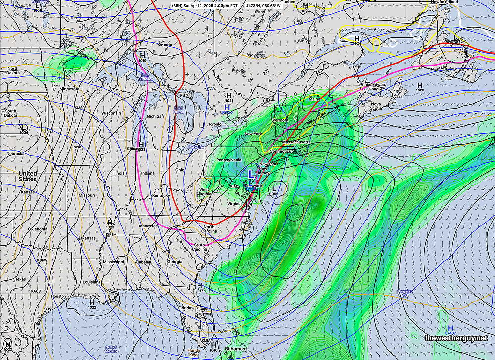
Rain, showers and even some thunderstorms develop late Friday night into Saturday morning with the warm front.

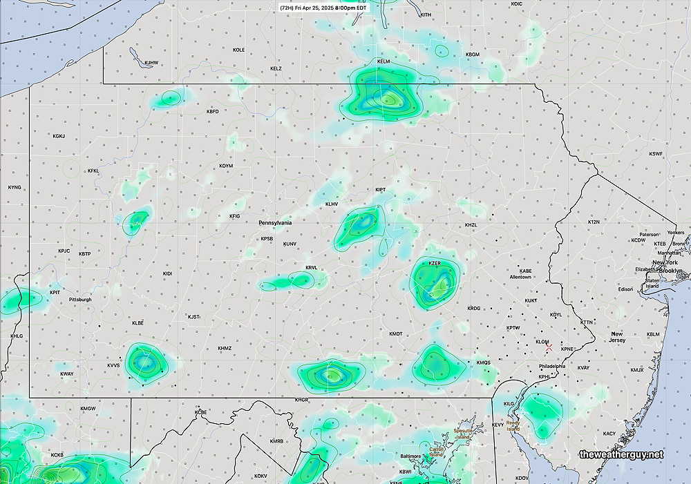
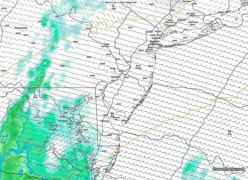
Showers and thunderstorms are likely with a cold front, current forecast to move through between 3 and 5 PM Saturday. Here’s the latest experimental RRFS-A forecast for 3 PM Saturday—

RRFS-A forecast for 3 PM Saturday. Showers and thunderstorms ahead of a cold front. (Click on image for a larger view.)

Originally Posted Wed 7:47 AM —Back to the weather! There hasn’t been much happening weather-wise around here. Beautiful and warmer weather has returned.

Unfortunately, I’m seeing a very dry, warmer-than-seasonal-average overall pattern developing this Spring, reminiscent of last year’s descent into a drought last Summer.

While rain is forecast for late Friday into Saturday, a pattern for the heaviest rain to move off to our northwest seems to be recurring. It’s really too soon to declare a hot, very dry, late Spring and Summer, but the current trend is moving in that direction and is disturbing.

Continued mild weather for the rest of the week. Showers move in late Friday afternoon or early evening with the system moving off to the northwest.

ECMWF-AI Single forecast for Friday at 8 PM The main system move off through the Great Lakes. (Click on image for a larger view.)

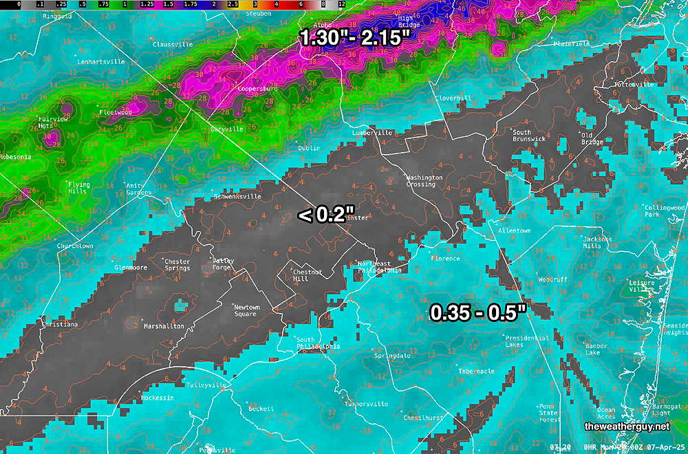
The AI models (at least those they release to the public) are low resolution in both spatial (0.25º resolution or about 21 km at this latitude ) and temporally (every 6 hours.) As a result, rain coverage on a weather map will look more impressive than what actually occurs.

Here’s the experimental RRFS-A forecast which has an hourly forecast and a 3 km spatial resolution. It’s forecast shows the much lighter rainfall—

04-23-25 06z RRFS-A forecast for Friday at 8 PM (Click on image for a larger view.)

WEEKEND WEATHER FORECAST

Posted Friday 04/11/25 @ 1:49 PM —An upper closed low pressure system will bring rain and chilly conditions, as it keeps the surface low developing off the coast from exiting.

Rain Friday night into much of Saturday. Here’s the ECMWF-AI forecast for 2 PM Saturday—

ECMWF-AI forecast for 2 PM Saturday. The Blue L is the upper low which will sit directly over our area. Rain much of the day, tapering later in the day. (Click on image for a larger view.)

By Sunday, the upper low has moved off the coast but a cold pocket of air aloft (red thickness contours) will keep cloudy skies. A shower can’t be ruled out. An inch to two inches of rain is currently forecast.

ECMWF-AI forecast for 2 PM Sunday. Rain has for the most part stopped, but the red thickness lines indicate cold air aloft that will keep things fairly cloudy. (Click on image for a larger view.)

The ridge developing in the Central US will bring milder temperatures and better weather next week.


THIS WEEK’S WEATHER

Thursday -Rain looks like it will wait

Posted Thursday 04/10/25 @ 10:29 AM — In contrast to some of the forecasts I’ve heard this morning, based on the experimental RRFS and the AI version of the ECMWF, it really looks like any rain here in the immediate Philadelphia area will occur AFTER 5 PM and perhaps not even during the evening hours. Any rainfall we do receive today looks to be very light.

06z RRFS (experimental) simulated radar/rain forecast for 5 PM Thursday. (Click on image for a larger view.)

Posted Wednesday 04/09/25 @ 11:41 AM — Depending on the model, it appears that rain will move in Thursday evening and will be on and off through Friday. Rain picks up in intensity later Friday evening as low pressure develops near the coast and likely lasts through much of Saturday.

A closed upper and mid-level low pressure system will remain over our area through the weekend. Cooler than average temperatures and unsettled conditions are likely.

The experimental RRFS model is handling Friday night quite differently compared to the ECMWF-AI model; the RRFS has a prolonged break in the rain later Friday afternoon into the evening and then has the rain picks up later that night. It will be interesting (experiment) to see if this holds.

06z RRFS-A model forecast for 7 PM Friday evening. The low pressure system expected to form along the coast is just taking shape well to our south Friday evening. (The majority of the other models, including the AI models, have heavy rain moving in in this time frame) (Click on image for a larger view.)


Showers Drizzle But Really not much Rainfall

Posted Monday 04/07/25 @ 5:39 PM — Despite all the clouds, fog, drizzle and showers/rain we had over the past several days, many areas did not receive much need accumulated rainfall. Here’s the 72 hour totals—

MRMS rain-gauge measured rainfall combined with rain-gauge calibrated and interpolated radar-based summary of ACTUAL RAINFALL RECEIVED. Color shading is in inches. Line contour numbers are in mm. (25.4 mm= 1 inch)     Over past 72 hours.  (Click on image for a larger view.)

The system will slowly exit tonight and Tuesday should become windy, partly to mostly sunny and cold. Highs in the low to mid 40s.


Previously Posted Sun @ 7:43 PM — —The slowly moving cold front that passed through today will spawn another low pressure system tonight into Monday. Cold air will filter in behind this low.

It should be noted that while several models were originally forecasting some clearing Monday afternoon, while the ECMWF-AI model has consistently delayed that clearing until Monday evening. Monday should remain cloudy with showers, with diminishing coverage and intensity during the afternoon hours.

ECMWF-AI forecast for Monday at 8 PM. (Click on image for a larger view.)

A well-advertised dip in the jet stream will occur over the Northeast this week following Colder than seasonal averages are expected.

Another storm is expected Friday into Friday night.


Weather… and Other Things 'Up in the Air'