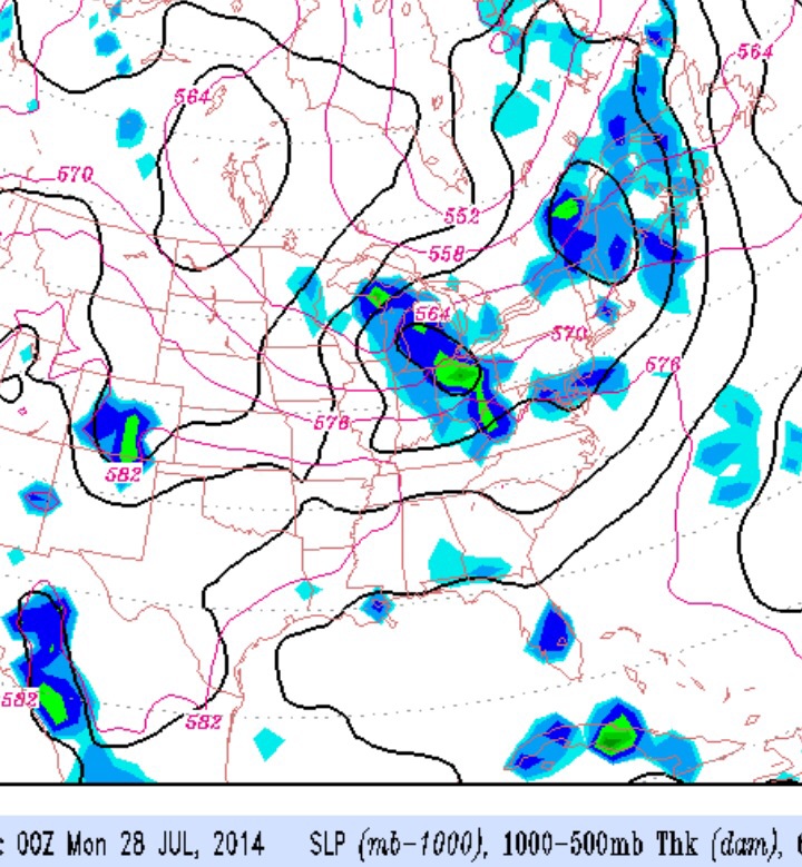
An interesting pattern change starts setting up over the weekend, as an amplified jet stream trough begins to develop over the Great Lakes and weak disturbances begin to rotate through our area as a cold front slowly advances. This amplified pattern is something we usually start seeing late August, not July, but it’s been a somewhat consistent feature of our cooler weather this entire year.
This amplified trough will eventually bring cooler temps and lower humidity to our area next week.
Saturday looks like the best day, although some clouds and showers may move in during the late afternoon. The approaching upper disturbances are more likely to bring showers and clouds Sunday. Details still uncertain.
The models have changed since yesterday and so has the forecast.
High pressure will block the advance of moisture from the south and the significant cloudiness previously expected will be less for later today, Saturday.
For Sunday, the expected easterly flow changes around to a southerly flow with less cloudiness. High pressure will nose down from the northeast, keeping us dry and reducing the cloudiness that had been expected.
Overall, a nicer weekend weather-wise is expected, specifically more sunshine on Sunday afternoon.
High pressure is drifting off to the northeast and an easterly surface wind flow will bring moisture and cloudiness to the Philadelphia area over the weekend. Areas to our east and the Jersey shore will have more clouds and areas to the west will have brighter skies. The models often have a tough time predicting the amount of cloudiness in the summer, so confidence in this forecast is a bit lower than past weeks.
No precipitation is expected.
Sat 7/19: Cloudy in the morning, some brightening skies during the afternoon. High 83.
Sun 7/20: Cloudy in the morning, some sun possible in the afternoon. High 82.