Philly Weekend Weather Forecast

The direct effects of Hurricane Joaquin will not be felt by us; it appears that the storm will be a few hundred miles out to sea at its closest approach.  (I’m not referring to the marine and coastal forecast; we’ll leave that to the highly qualified meteorologists at the NWS.)

By the way, I’m really disappointed with how the Navy NAVGEM forecast was so off.  I guess I can’t rely on it, as I had in the past with the now-discontinued Navy NOGAPS model.

Stream of moisture from Hurricane Joaquin today.

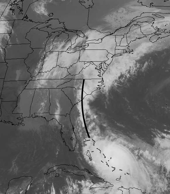
Joaquin is throwing back a significant moisture plume into the stalled frontal boundary and our heavy rains today are due to this source of tropical moisture.

While I think we do have a handle on the future path of the hurricane, its presence always affects the non-tropical weather models.  So the forecast for this weekend is low confidence, despite our knowledge of the hurricane’s path. 

I’m far from being a numerical model scientist, but it’s my humble guess that a tropical storm represents some sort of mathematical discontinuity in the model physics.  It’s been my experience that the model forecasts suffer with any deep tropical storm in the picture, even when predicting the non-tropical elements.

So with that said, Saturday looks like rain will be tapering in the morning and may end late morning or early afternoon.   (However, the latest GFS LAMPS forecast now shows rain continuing well into the afternoon.  🙁   Highs will be in the mid to upper 50s.

For Sunday, look for mostly cloudy skies (maybe some sunny breaks) and dry.  A quick shower can’t be ruled out in the afternoon.   High near 63.

I don’t try to second guess the models and I’ve learned they can’t be relied upon in this sort of scenario.  So we’ll have to see what actually happens this weekend.


Joaquin Update

A quick update.  The model tracks have changed significantly over the past 24 hours.  A greater number of models take the storm due northward, relatively far off the east coast, but hitting New England  next week.  This track would have a minimum impact on our area.

This morning’s NAVGEM still had the storm moving into the Carolinas.  Haven’t been able to obtain the afternoon run yet.  Will update again later.

Update: This afternoon’s NAVGEM follows the pack and shows Joaquin staying off the coast. Its path is now very similar to the official NHC track.   Looks like this storm will have minimal effects in PHL; we may not get any rain directly from this system.  Even more amazing,  if the storm is far enough offshore, we might get crystal clear skies due to subsidence far from the eye of the storm. 

Joaquin Update

The forecast for the potential path of Hurricane Joaquin  continues to change., with the range of solutions– most have the storm  making a  turn into North Carolina , then making a sharp turn over land towards the Delaware Valley, affecting us as a tropical storm.

A few models have a track directly to the Chesapeake Bay area.   The fewest number of models have the storm bending east out to sea.

Timing and intensity has also changed, with the actual storm or remenants reaching our area  in the Monday to Tuesday time frame.  Some models have the intensity as a Category 3 storm before landfall, while a few now have it as an early Category 4 hurricane.

My favorite model for tropical sytems, the Navy NAVGEMS, has the storm entering South Carolina Sunday and weakened remnants making it north to our area.   This model differs signficantly from the official NHC track which now takes the hurricane directly up near Delaware/NJ coasts.

The GFS has moved to very northward movement missing us and hitting southern New England.   So predicted tracks are really all over the place.

Regardless of the final intensity and location, many models have the moisture ouflow of the storm being picked up by upper winds and converging on the stalled frontal boundary just to our south, resulting in heavy rains unrelated to the actual storm location during the weekend.

So this is still a difficult impossible forecast to nail down.   Will update this evening.


Weather… and Other Things 'Up in the Air'