PHILLY MONDAY SNOW FORECAST- SUNDAY NIGHT EDITION

The models continue with the scenario of low pressure moving along a stalled frontal boundary.

Reviewing today’s NAM and GFS data, the rain-snow critical thickness cuts right through Philadelphia.  QPF values are about 0.39 inches water.

Additionally, until precipitation gets going, it will take some time for dynamic cooling to establish a cold enough profile.  However the middle levels of the atmosphere will remain too warm for snow to form in much of Philadelphia, south and east.  

For most of Philadelphia, rain may mix with some sleet and maybe some rain snow mix after 4 AM, but should barely accumulate, even on grassy surfaces.  It should be wet, not white, in most of Philadelphia. 

Precipitation ends about 9 -10 AM.

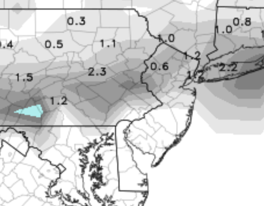
For extreme Northeast Philadelphia, Chestnut Hill and areas of Montgomery County and Bucks County, 1/2 to 2 inches measured on grassy surfaces is possible, but even less on roadways.     The graphics below best depicts this snow accumulation potential—

Snow Forecast Philadelphia
NAM Snow forecast in inches for Monday 4/2/18  (ignore the 0.8 inset graphic)

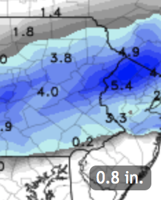
Much of South Jersey will have no accumulation.   Temperatures rise in the morning and rapid melting will occur with whatever falls.


PHILLY MONDAY STORM UPDATE- SUNDAY AM EDITION

As mentioned in last night’s post, the models have a small low pressure system developing and moving along the stalled frontal boundary that will be to our south late Sunday night into Monday.  Some snow expected in Philadelphia, although ground temperatures will be warm proceeding the storm, so not much is expected on roadways.

Both the NAM and GFS have temperatures cold enough, with dynamic cooling for rain to change to snow. QPF values have been somewhat decreasing with each model run.  NAM QPF is about 0.34 inches water, but not all of this will fall as snow.

In favor of some accumulation is the fact that much will fall before sunrise, eliminating April solar insolation effects.

A coating to 2.5 inches possible in the immediate PHL area, as measured on grassy surfaces.  Here’s the NAM and GFS snow total predictions:

NAM total snowfall
NAM total snowfall (grassy surfaces) for Monday


GFS grassy surfaces snowfall
GFS snowfall prediction (grassy surfaces) Monday


As always, the NAM has higher QPF than the GFS and higher snowfall totals.   An average of the two is a best bet with a lean towards the NAM.  (With these Spring storms, the model snowfall prediction is likely better than any thing I can calculate. )

I’ll update this evening  around 10:30 PM or so.


Weather… and Other Things 'Up in the Air'