COLDER, ACTIVE WEATHER PERIOD COMING UP

Thu 09:30 AM Update — What had been expected to be a colder, active pattern next week (title of original post) is unfolding to be a seasonably cold, uneventful pattern.   A flat and zonal flow as depicted in the “540  thickness” line (RED) of the Canadian Global model captures the uneventful flow and is NOT conducive to storm development—
Canadian Global model forecast for next Friday, Jan 22nd.  Red line (“540 thickness line”) couldn’t be much flatter and  it’s not conducive to storm development.  (Click on image for a larger view.)

We’ll have a dip in the jet this weekend with an upper low affecting our area, but the original expectation for a continued amplified pattern next week has faded. As for the very cold weather, temperatures in Canada have significantly chilled, but there’s no indication at this time that it will move down to affect our area.

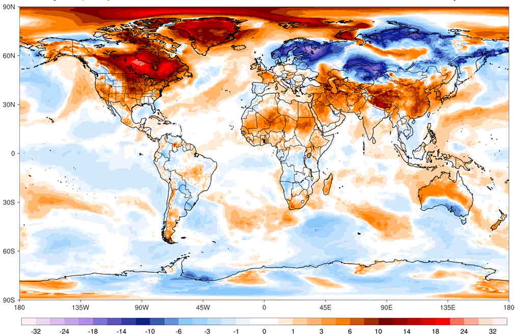
Addendum: Here’s the current day temperature deviation compared to the period 1979-2000— 

GFS temperature anomaly Dec 14th compared to seasonal average 1979-2000. (ºC)  As cold as things are getting in northern Canada, temperatures are relatively warmer than average.  (Click on image for a larger view.)

Wed 09:48 AM Update — After looking at the latest GEFS (statistical ensemble) model as far out as it predicts -384 hours in the future – I don’t really see any intrusion of extremely cold air showing except in the far northwestern US.  In fact, the jet flow is looking rather ‘flat’, (not amplified) so previous expectations of an active pattern next week may be incorrect.  The flat pattern does not lend itself towards storm development.  Cold air starts building in as shown below in the forecast for Sat, Jan 23rd below, but that’s a ways off—
GEFS forecast Saturday Jan 23rd showing high pressure building in. (Click on image for a larger view.)

Tue 10:52 AM Update —  A plunge of cold air will cause low pressure development over our area Saturday.  It looks like RAIN for our area on Saturday.
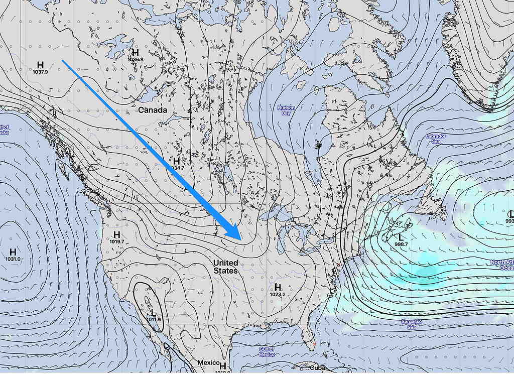
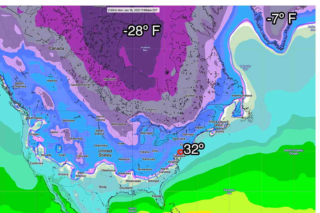
Despite talk about  displacement of the”the polar vortex” as suggested by signs of “stratospheric warming”, current statistical models have deep cold in Canada, but not deep or cold enough to extend into the US at this time.  Current minimum temperatures from the statistical ensemble model (GEFS)—
Minimum Temps GEFS model for Monday 7 AM EST (Click on image for a larger view.)

This morning’s models are beginning to show an outbreak of very cold air around the last week of January.

Mon 06:22 PM Update — The pattern change expected over the weekend is still showing in the models.  It appears it will be too warm for snow here, but there’s high uncertainty about Saturday’s forecast. Low pressure is expected to develop along the coast or slightly inland, keeping us in the warm sector, maybe with a brief changeover to snow before ending Saturday. Stay tuned.  

This winter has been relatively quiet with average to above average  temperatures, and with the exception of one storm, not much snow. 

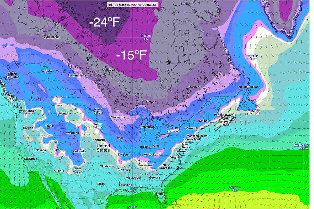
As mentioned in several posts over recent days, the models having been showing a strong signal towards a pattern change during the period January 16th through January 20th.

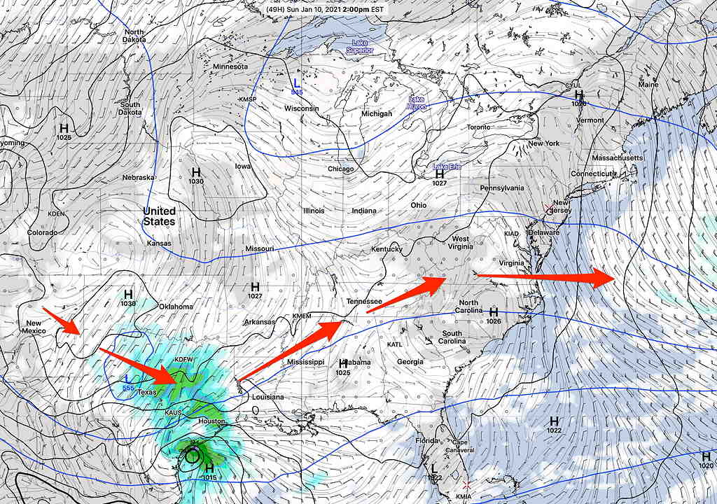
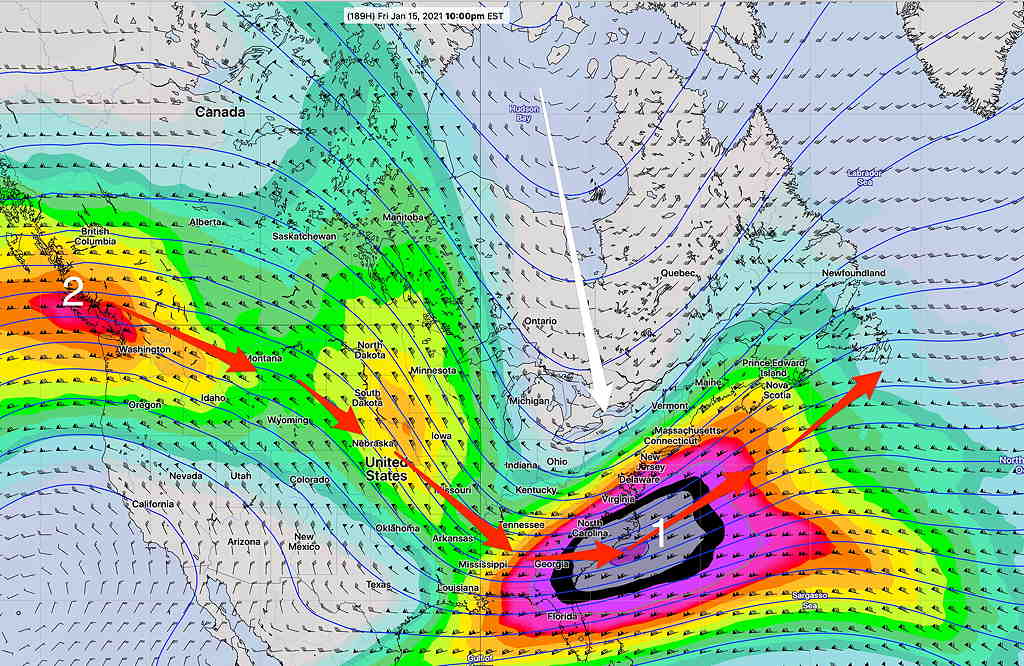
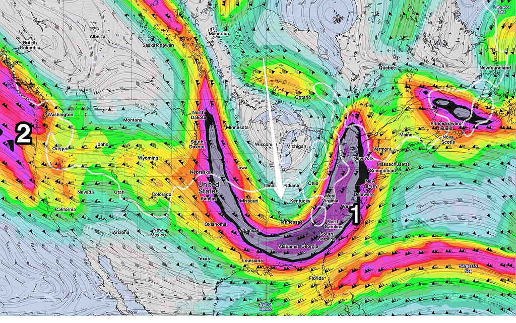
Colder air has been building in Canada and it appears that a southward plunge in this cold air will start occurring during the above timeframe, forcing a dip in the jet stream as a jet streak (1) causes the development of low pressure—

GFS version 16 forecast for Friday- 10 PM  (Click on image for a larger view.)

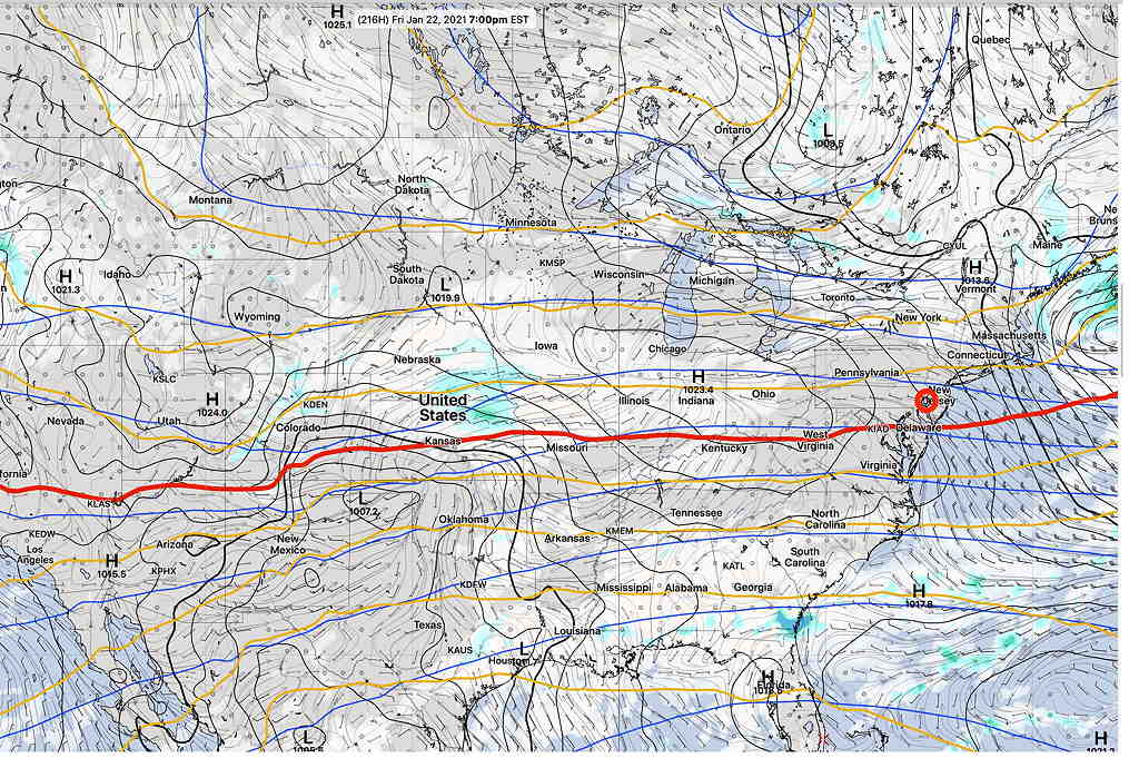
The models have not come together with exact timing and placement of this plunge.  The GFS (version 16) has rain, changing to snow for this first impulse: not a big storm. 

GFS 16 forecast Saturday, 1 AM  (Click on image for a larger view.)

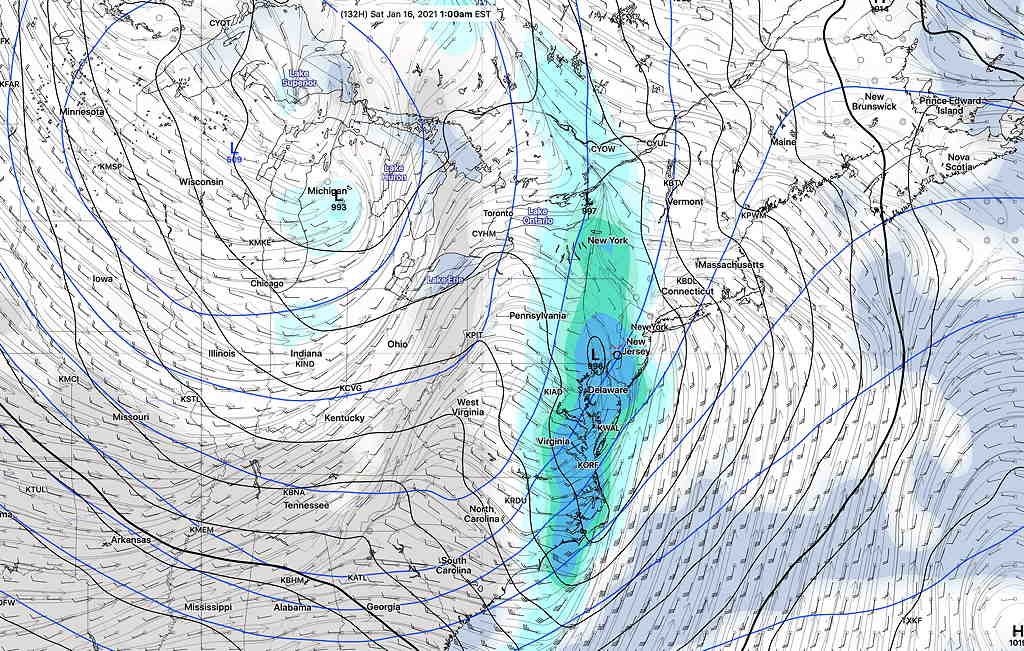
The Canadian global model is similar to the GFS 16, with snow developing Saturday morning.

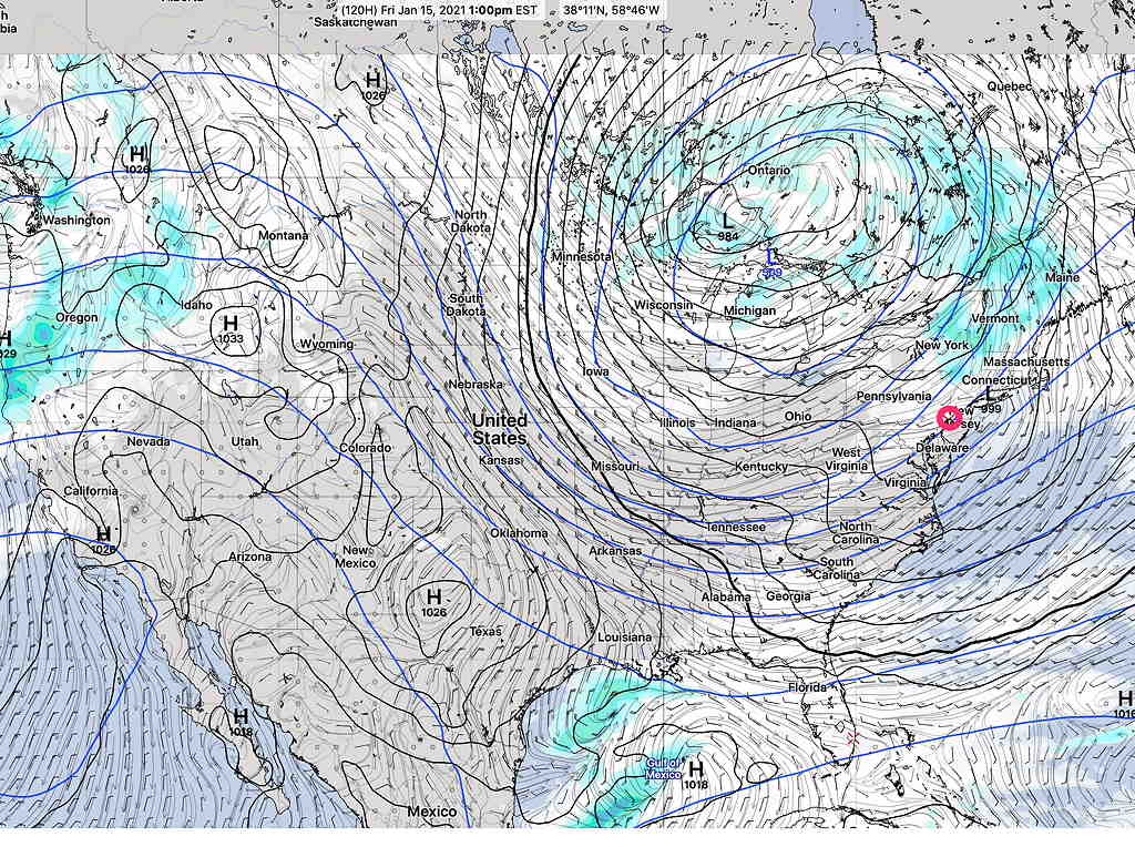
I should add that the current, operational GFS (version 15.2) is faster and does NOT have this storm form until the impulse is north of us—

Current Operational GFS version 15.2 Forecast for 1 PM Friday


Either way, colder temperatures are expected next weekend.

On the horizon is another impulse (#2 above), which depending upon the model, shows the possibility of a significant nor’easter a few days later.

It’s way too early to really know specifics, but the take-away is that colder temperatures are on the way next weekend and a more active winter weather pattern likely follows.

WEEKEND WEATHER FORECAST

New additions to this website — weather science info links.
Saturday Update: The period from January 16th through January 20th continues to show a strong signal for coastal low development and possible snow.

Low pressure that brought clouds on Friday will move east and away from us on Saturday.  High pressure will build in on Saturday with mostly sunny skies, but occasional cloudiness from the upper air trough may move in late Saturday—

GFS Forecast 2 PM Saturday  (Click on image for a larger view.)

Saturday—

The upper flow briefly becomes a slight ridge on Sunday.   Skies on Sunday remain mostly sunny here as a low pressure system develops near the Gulp of Mexico—

GFS Forecast Sunday 2 PM


(Seasonal averages this week—  high 40º  low 24º  Blue Bell)

Sunday—

• After early morning clouds, mostly sunny,
• High temperature 41.9º sd 1.9º (NBM model) Blue Bell.
• Light winds from the NW

The low pressure system developing on Saturday will pass to our south Monday into Tuesday.  Most models (except the Canadian and German ICON) have the light snow shield missing us. The trend has been for the light snow/flurries shield to be a bit further north.  

SO WHERE’S THE SNOW?

I should preface this post by saying that I enjoy trying to predict snow rather than dealing with it after it has fallen. Pretty when it falls, a pain afterwards.

That said, I’m being asked, ‘ so where’s the snow?’

I’ve mentioned since the end of November that my sense of the weather pattern so far this winter is what I like to call “a lack of very cold air” to our north.

Here’s the current GFS statistical ensemble forecast (GEFS average) expected minimum temperatures for next week—

GEFS statistical average minimum temperature forecast for next Friday.  (Click on image for a larger view.)

Well, maybe you’re thinking, -24ºF seems awfully cold to me? The truth is, when things get going, temperatures are as low as -40º to -50º in the same areas above, especially in Greenland. (Greenland is looking awfully warm this year.)

Contrary to what many weather entertainers on TV seem to suggest, the jet stream doesn’t just do it’s own, arbitrary thing. The jet stream, a fast flow of winds at about 35,000 to 40,000 feet in winter, is a river of air actually flowing in the three dimensional “valley” between air masses.

It is the density and shape of the cold air mass that determines the shape of the valley and of the jet, not the other way around. In essence, the jet flow shape in winter depends on the “sag” of very cold moving southward, as depicted below with the white line—

GEFS forecast Jet Flow (300 mb winds) next Friday (Click on image for a larger view.)


Notice that the white line is tilted slightly eastward instead of straight southward.  The relatively “not so cold air” up north doesn’t have the mass density to dive straight south.     The jet stream flow (red arrows) isn’t suppressed directly southward, but rather southeastward.  

There also hasn’t been much of a blocking effect of a large cold air mass over Greenland and the Northern Atlantic to cause the same jet flow to bend back north up the coastline. 

As a result the two “jet streak” impulses (numbers 1 and 2 above) develop low pressure systems, but these move out to sea.  

So we need colder air in Canada, and colder air in Greenland and the North Atlantic.

The time period depicted above (January 15th-20th)  does show some positive trends towards snow here:

  • Temperatures are colder in Canada than they’ve been.
  • The jet flow next week will be “less split” than it’s been.   It does appear that some phasing may occur between the northern jet flow shown (disturbance #1 above) and the southern jet flow (just visible on the map from Mexico and near #1)

So, some colder temperatures and some action is possible January 15th – January 20th, although not currently captured on the models.  Stay tuned

Weather… and Other Things 'Up in the Air'