Category Archives: Winter Storm Outlook

DOUBLE JEOPARDY STORM FOR THURSDAY INTO FRIDAY

An interesting weather setup is being forecast by most models for Thursday into early Friday for our area.

There’s a blocking high pressure system and an upper cut off low in the midwest.

NAM Model
Upper Low- Blocking High Setup NAM model-  Thursday evening.

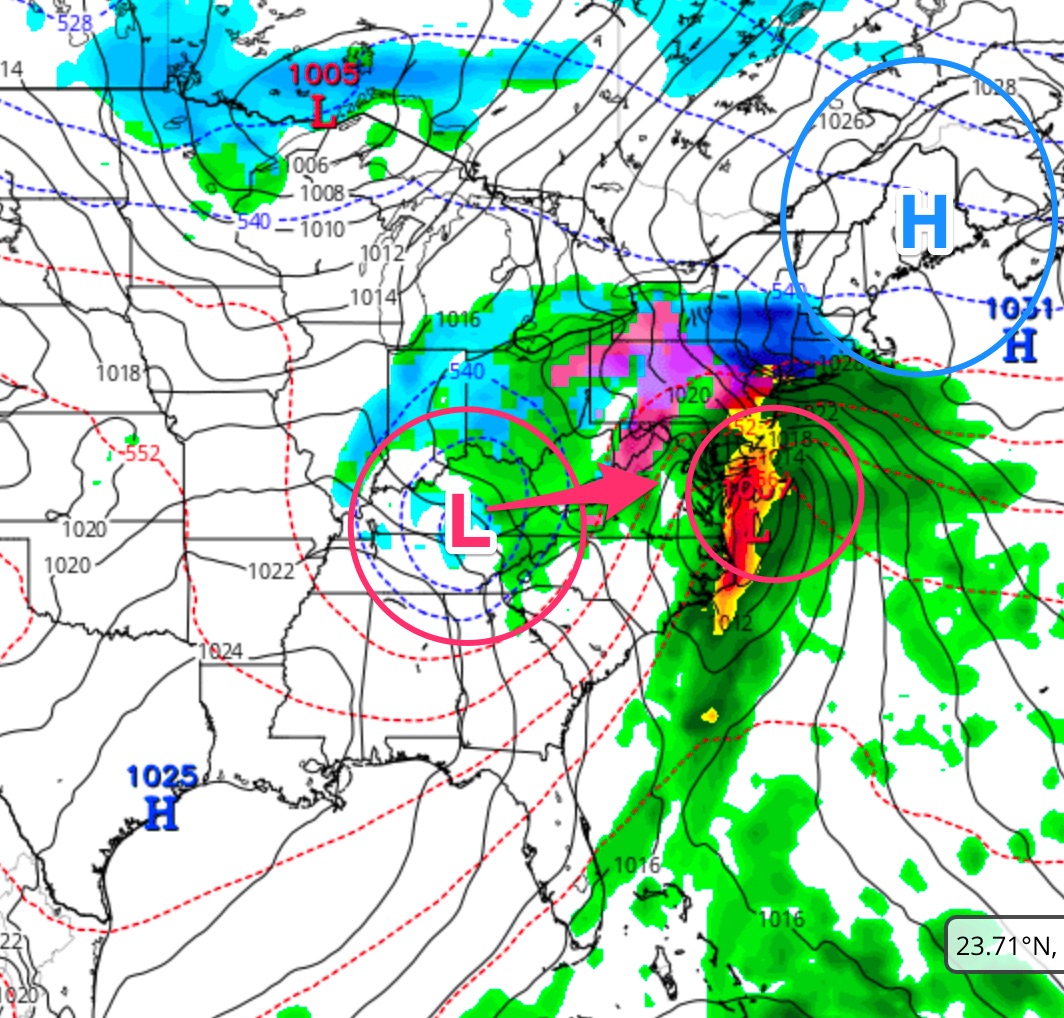
The blocking high pressure will give us the low level cold damming effect, trapping cold air at the surface.  This is what will give us the chance of sleet/freezing rain Thursday morning.

The upper low in the midwest will merge with the surface low on the coast.  This will cause intensification of the surface low Thursday night, bringing in enough cold air to turn precipitation to snow Thursday night into early Friday morning.

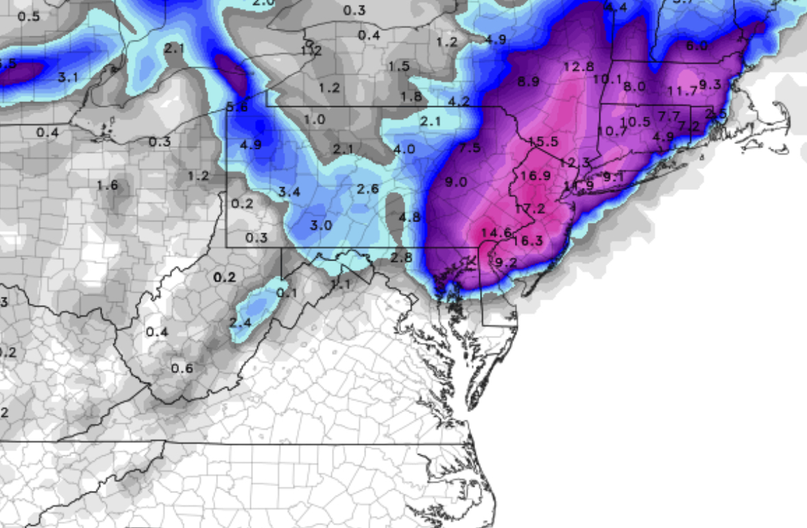
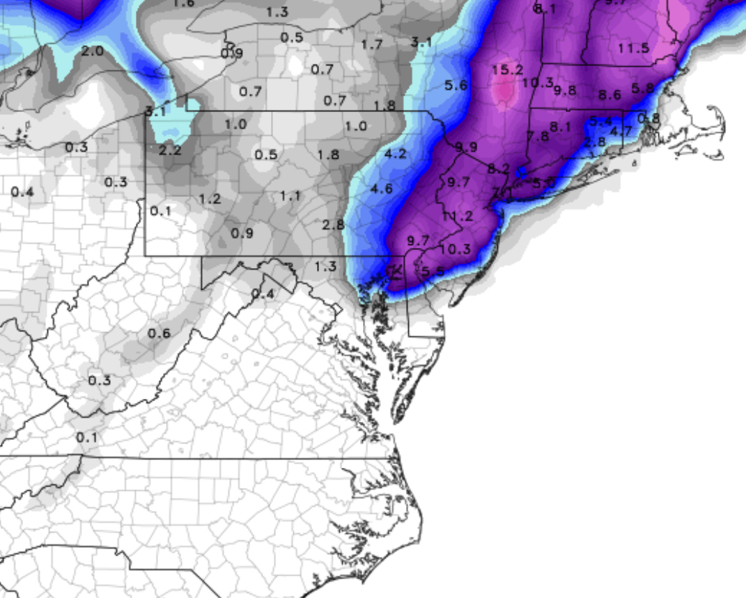
Let me start by saying that Thursday early morning rush hour should be OK, but moisture moving in from the south during the morning will fall mostly as sleet and freezing rain, especially north and west.  (There may be a few snowflakes at the very start.)

I do NOT think we will get snow in the immediate PHL area and surrounding suburbs on Thursday morning or afternoon.   This is a sleet/rain event for much of Thursday.  Despite the fact that the GFS is calling for snow, based on critical atmospheric thickness levels and the NAM, I think this will be sleet/freezing rain to rain event for early Thursday into Thursday afternoon.

Here’s where things get interesting for late Thursday into Friday,  something I alluded to yesterday—

Sometime late Thursday into Thursday evening, the upper cut off low is expected move and merge with the coastal system, causing rapid intensification.  The increase in the precipitation rate and the cold air associated with the upper low will cause precipitation to change to snow in the immediate PHL area Thursday night into daybreak Friday.  Too early to determine if there will be any accumulations.  (The latest GFS doesn’t bring in that much cold air aloft.)

As stated in recent posts, the models have been anything but consistent over the past week.  But this scenario has been solidifying over the past two days.    Stay tuned.


EARLY WINTER CLIMATE OUTLOOK

I received an email from a follower of this blog asking for my thoughts regarding the upcoming winter.   Here’s what I replied:

Thanks for the confidence you expressed in my forecasts. Winter weather seasonal forecasts are more about climate than weather.  Even the National Center for Climate Prediction doesn’t do too well with these very long range forecasts.

That said, I usually take a stab at the Winter Weather Seasonal Forecast towards the end of November.  By that time, any pattern that may become established will have revealed itself.

But if you want an early sense of things, the nadir in the sunspot cycle suggests plenty of cold air.  The current dips in the jet stream suggest a stormy winter.   And an expected appearance of El Niño in the Pacific suggests plenty of moisture.

So expect a cold winter with plenty of storms and plenty of snow.   That’s my best bet right now.  But things could change if the jet stream dips change over to the western side of the US.

PHILLY SNOWSTORM FORECAST 9:40 PM EDITION

The tonight’s NAM model data is becoming available.  Here are the trends:

Higher QPF values- precipitation falling as water has increased significantly to 1.80 inches water, in some areas, over 2.0 inches water!

The predicted vertical thermal profile is much COLDER; indeed, critical “thickness levels” and temperatures now support snow into New Jersey where previously it was thought to be mostly rain or rain mix.

With these changes, there’s been a significant increase in predicted snow totals!  Here are the NAM 10:1 snow totals by area:

NAM Final predicted snow totals 10:1 ratio

There are other algorithms that try to take into account other factors such as melting.  One is called the Kuchera Snow Algorithm.

Kuchera algorithm
NAM Kuchera Algorithm Snow Accumulation

I don’t generally find the predefined snow algorithms that useful or accurate.  I believe the 10:1 simple algorithm will do best here and may understate snowfall at times. An average of the two might also prove correct for this storm.

The reason I’m presenting both predefined snow algorithms is to show that significant snowfall is now expected in Philadelphia, NJ as well as in PA.

[su_note note_color=”#ebf2d9″]So we’re looking at 9-17 inches of snow, based on your location, as shown on the above maps.[/su_note]

Timing:  Precipitation as rain is starting as scheduled (9PM) and will mix with and turn to snow by 1-2 AM in western sections and a bit later along the I-95 corridor.   Heaviest snow during the morning and afternoon hours on Wednesday, ending about 7PM or so.

Temperatures are expected to fall to about 32-33 degrees by 2-3 AM with dynamic cooling that will occur with heavier precipitation on Wednesday

Winds will be 15 to 20 mph with gusts near 25 during the day on Wednesday.

The GFS model data becomes available about 10:45 PM.  I expect the GFS QPF values to be less than the NAM values; it always is.  I still think we’re talking about a major snowstorm for Philadelphia and the immediate areas.  This is a high confidence forecast.

I’ll amend this post with the GFS data if it presents a problem with this forecast.

[su_note note_color=”#ebf2d9″]10:45 PM – Tonight’s GFS model data is similar to the NAM. QPF values 1.43  inches water with distribution of precipitation maximum centered around I95, similar to the NAM.  I believe the NAM 10:1 snowfall map above  is a good estimate. [/su_note]