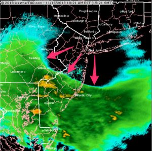
[su_box title=”Weather Update Sun 9:00 PM” box_color=”#defcdc” title_color=”#000000″]Today’s NAM shows about 1 inch of snow Tuesday evening.
Today’s GFS and FV3-GFS shows some low pressure development along the front with potentially higher snow totals, especially north and west of the city. Current QPF for these models has increased to 0.60 inches water, and current snow algorithms show about 3 inches of snow. Stay tuned. [/su_box]
A weak cold front will move through about 6 PM and clouds will increase ahead of the front this afternoon. A widely scattered shower is possible with the frontal passage.
Skipping over to Tuesday, another cold front, this time an arctic front, will move through during late afternoon into the evening. Rain is expected prior to the frontal passage, during the late afternoon.
As the strong front moves through, the rain is expected to change over to snow before ending a little after midnight Tuesday. Total QPF with this front is about 0.35 inches water.
Much of the precipitation will fall as rain, but about 0.10 inches water will fall as snow, more to the north and west of Philadelphia. Current snowfall totals is about 1, possibly 2 inches, with the higher totals north and west.

