Category Archives: Philadelphia Weather Outlook

HEAT, THEN RAIN

Tue 06:19 PM Update — The models are coming together to forecast a severe weather day Thursday.  It looks like we’ll have very heavy thunderstorms in the afternoon. The GFS is showing rain accumulations in the range of 2 inches.  Stay tuned.

It’s been well-advertised that Tuesday and Wednesday will be very hot and humid days, with high temperatures in the mid to upper 90s and apparent temperatures (heat indices) approaching 100.

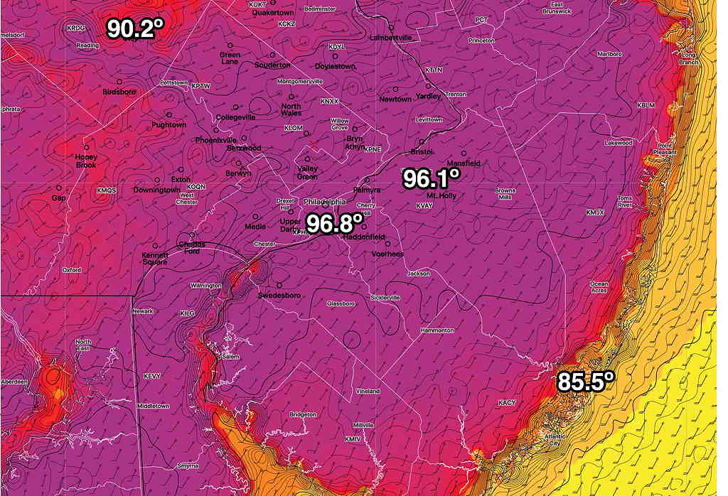
Update: NBM has highs on Wednesday 97º ± 2º (Blue Bell) The ICON has a high of 98º. It appears it will be in the low 90s on Thursday.

The latest NBM high temperatures for Wednesday—

NBM High Temps Wednesday (Click on image for a larger view.). (This has been updated above)

Starting Wednesday night, a front will affect our area and a significant pattern change, at least for the short run, will occur.

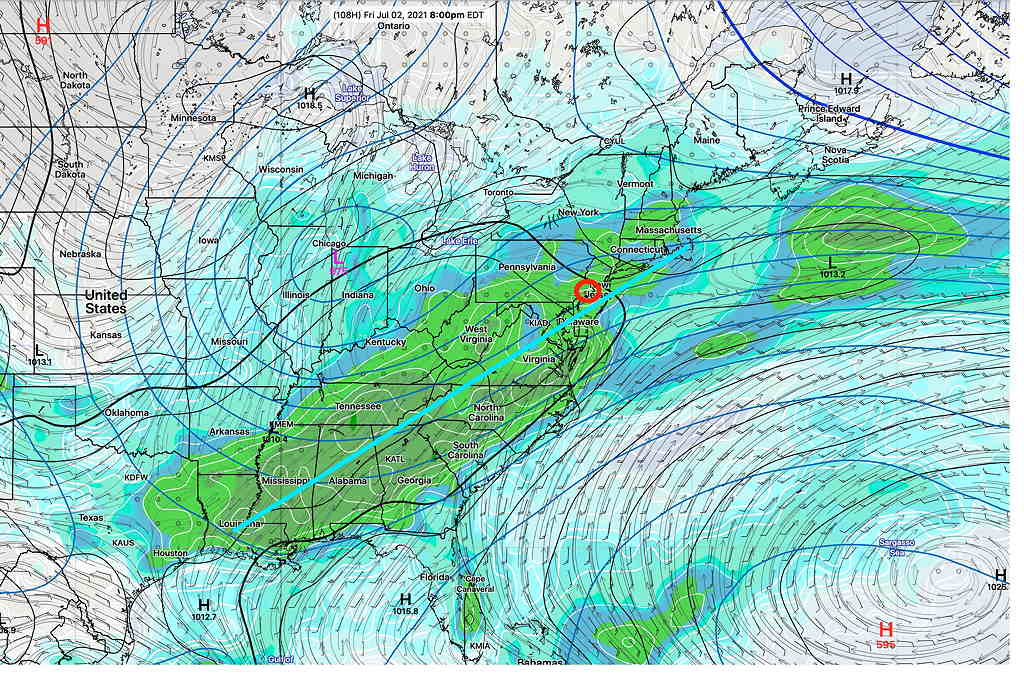
From Wednesday night through at least Saturday, the models are in surprisingly good agreement that a cold front will slowly move through and stall just south of the Philadelphia area. Rain, possibly heavy, appears to be the current forecast for Thursday through Saturday, as waves of low pressure move up along this front and an upper cyclonic flow and an upper closed low support rainy conditions. We may clear out by Sunday. Hopefully before.

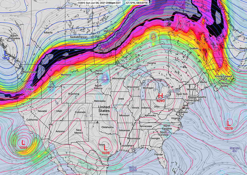
Here’s the current GEFS forecast for Friday 8 PM showing the upper low near Chicago—

GEFS forecast Friday 8 PM, showing an upper closed low in the Great Lakes and an oblong area of low pressure centers along a stalled front. (Click on image for a larger view.)

Some of the models are cranking out a total 1-2 inches of rain by Saturday.

When fronts are forecast to stall, it’s not always a sure thing. So there’s always hope that the forecast will improve. Stay tuned.

I’ve added a weather model glossary to this site.  Hover/click on the underlined model acronym for pop-up information.

THUNDERSTORMS: TUES

Tue 04:57 PM Forecast Review — The models did well with the thunderstorm forecast for today. The storm activity should continue into the early evening. The latest HRRR is forecasting some intense dynamics around 6PM in Philadelphia and into NJ.

Some of lightning today was cloud->ground and was dangerously spectacular to view.   CAPE (Convective Available Potential Energy)  values today were high —in the 2800 range (compare to last week’s storms which were only in the 1700 J/kg range.)

A repeat performance expected on Wednesday, likely 2-6 PM and somewhat more in NJ.  

Another very warm day is in store for us on Tuesday. Temps will be in the upper 80s, but an increase in humidity will more than make up for it.

Upper air disturbances will move through, around noontime, triggering scattered showers and thunderstorms in many areas, starting as early as noon- 2 PM and lasting in some areas into the evening.

HREF (High Resolution Ensemble Forecast) hourly precipitation with standard deviation, at 12 PM, 2 PM and 5 PM with increasing areal coverage. (Click on image for a larger view.)

High CAPE (potential energy), high instability values and high precipitable water values could make for some heavy rains in localized areas. Overall, the models are cranking out 0.5 inches of rain.

INTERESTING THURSDAY & SUMMER-LIKE WEEKEND

Wed 7:51 PM Update — A warm front moves through between 4 AM and 7 AM Thursday morning with showers and thunderstorms.  

A cold front moves through Thursday evening and there will be thunderstorms starting between 5:30 PM and 9 PM Thursday evening and continue into the pre-dawn hours of Friday.   These storms could be strong to severe – several parameters indicate this possibility.

Yet another front moves through Friday afternoon! 

Temperatures on Sunday may be in the low to mid 90s!

I’ll provide an update on Thursday morning.

The cool weather we’ve had recently will slowly depart as a warm front moves through late Wednesday into Thursday morning.

Some showers and thunderstorms will arrive with the warm front before daybreak Thursday. (see timing update in green box above.)

A cold front will move through later on Thursday. Some heavy thunderstorms are likely with this frontal passage late Thursday afternoon and evening.

Some showers and thunderstorms will arrive with the warm front before daybreak Thursday. (see timing update in green box above.) I’ll keep an eye on the specifics.

After a brief cool down Friday, the upcoming weekend promises to be warm and summer-like as an upper air high pressure system parks moves over the Great Lakes with the jet stream pushed into Canada—

250 mb Upper air forecast for Sunday  2 PM with jet stream far to our north  (Click on image for a larger view.)


I‘ll be providing an update about Thursday’s storms if they continue to look significant.