Category Archives: Philadelphia Area Weather Forecasts

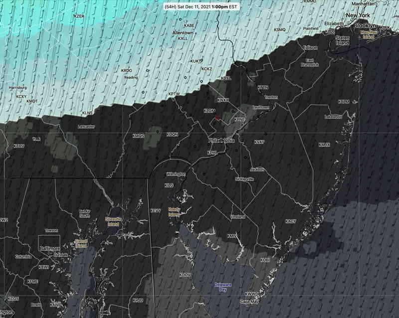
Update Fri @ 9:05 AM — A shift in the model blend (NBM) towards the higher resolution models shows the warm front that moves through Friday night lingering through Saturday morning with fog and light drizzle. Drizzle ends during the morning. Winds pick up during the late morning. VERY WINDY. Most of the afternoon (and possibly early evening) rain-free. Highest temperatures in the late afternoon 68-70º.

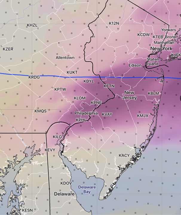
Front moves through with showers, possible thunder, about 5-8 PM.

Sunday looks to be sunny and breezy.


Update Thu @ 10:25 PM —The weekend has come within the range of the high resolution models. Saturday is looking very cloudy with low clouds in the morning. The NAM-NEST has light sprinkles/drizzle in the early morning. Most models (but not all) have high temperatures 65°+- 2.5°.. Very windy, as discussed below. Rain showers seem to reduce in intensity with the front late afternoon/evening. Check for my regular weekend weather forecast tomorrow.


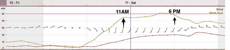
Update Thu @ 4:27 PM — The latest NAM-NEST wind meteogram for Saturday—

NAM-NEST meteogram (Blue Bell) Saturday Winds and Wind Gusts. 40-50+ mph! (Click on image for a larger view.)

It’s looking like most of the daytime hours will be dry with the actual cold front moving through about 6-8 PM.


Very mild temperatures still predicted for Saturday with possible recording breaking high temperatures in the upper 60s! Unfortunately, the models are also predicting cloudy conditions for much of the day.

The other big story may be the gusty winds that develop in the morning and continue through the evening. The GFS and NAM are predicting wind gusts in the 40-50 mph range for much of the day.
(The model blend (NBM) is only showing gusts to 35 mph.)

The latest models have the actual frontal passage about 6-7 PM (instead of the afternoon.) Rain and possibly some thunder will precede and accompany the cold front.

NBM12z cloud (black) and 1 hour accumulated rain (blue-green) forecast for 1 PM Saturday. The current NBM has rain overspreading Philadelphia 2-4 PM. (Click on image for a larger view.)

Update Wed @ 8:00 AM — No snow for today.

While very mild temperatures are forecast for Saturday, a very strong cold front will move through Saturday afternoon, preceded by high winds, showers and even some thunderstorms. Some showers and high winds may begin in the morning, limiting the enjoyment of the 60º + temperatures.

WEEKEND WEATHER FORECAST

Update Sat 7:15 PM— Today’s cloud forecast was spot-on. Sunday’s forecast below looks good as well with plenty of sunshine, occasional clouds. Some clouds move in later in the afternoon.

Word has gotten out about snow for Wednesday. Since that time period is over 90 hours in the future, the higher resolution models don’t extend into that forecast range, making snow accumulation forecasts quite unreliable. It was refreshing to hear the Channel 10 meteorologist refuse to make a snow accumulation forecast until Monday.

Nonetheless I’m sure people are curious about the snow accumulations being forecast by the longer range models. Snow is forecast to start before daybreak Wednesday, change to rain, and then change back to snow Wednesday night. Basically, snow accumulations are in the 0.5-2 inch range from just outside the city, with higher amounts possible towards Allentown and northwest NJ.

Curiously, most models have snow accumulations in our immediate area where surface temperatures are forecast to be over 32º. Again, too soon to make any ‘predictions’. Stay tuned.


Update Sat 7:30 AM— Last night’s models continue with the forecast of an area of cloud development Saturday directly over the Philadelphia area. The NAM NEST and the new CMC GEM models have brief clearing late morning before clouds redevelop as shown below—

HREF Ensemble mid-level cloud forecast for 1 PM Saturday looks similar to the NBM posted last night. The NAM-NEST and CMC GEM area similar, but have the area of cloudiness somewhat further south. Areas in Chester county and upper Montgomery county are forecast to be more sunny. (Click on image for larger view.)

Initial Post Discussion—[post_published]

As described earlier this week, a flat jet flow has prevented active weather from developing this past week and this upper air flow will continue into this weekend. Much of the low pressure development is in Canada. Things look to change next week.

A frontal boundary stalled to our south will allow for weak low pressure to develop Friday night.

Saturday

A few sprinkles may develop and end before daybreak Saturday.

The low will move off to our south and east, but moisture will remain in the form of mid-level cloudiness through much of Saturday.

NBM Cloud forecast for Saturday 1 PM (Click on image for a larger view.)

Not all models are on-board with this cloudiness Saturday (several models have over-forecast clouds recently) and this cloud forecast is lower confidence than usual. High temp 49.6º ± 1.4º (NBM) Blue Bell. (Seasonal average high is 46º-48º)

High pressure builds in and Sunday will be mostly sunny, but with some occasional clouds in the afternoon, especially west of the city.

High temp 46.9º ± 1.7º (NBM) Blue Bell.