Category Archives: Philadelphia Area Weather Forecasts

WEEKEND WEATHER OUTLOOK

#weather #paweather #wx #pawx #philadelphia #phillywx

Friday Update- Rain on the way

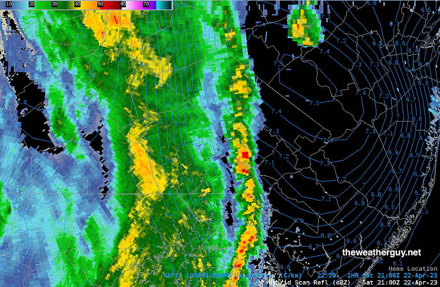
Update Fri 04/28 @ 9:28 AM — The latest radar has the rain somewhat closer to us than predicted by last night’s models. Nonetheless, the RAP is showing a bit of push-back of the rain advance, based on isentropic (thermal energy) analysis.

MRMS radar at 9:22 AM with superimposed RAP model 300K level Theta-E isentropes shows a bit of an energy wall to surmount for the rain to move into the PHL area, despite being just 40 miles away.

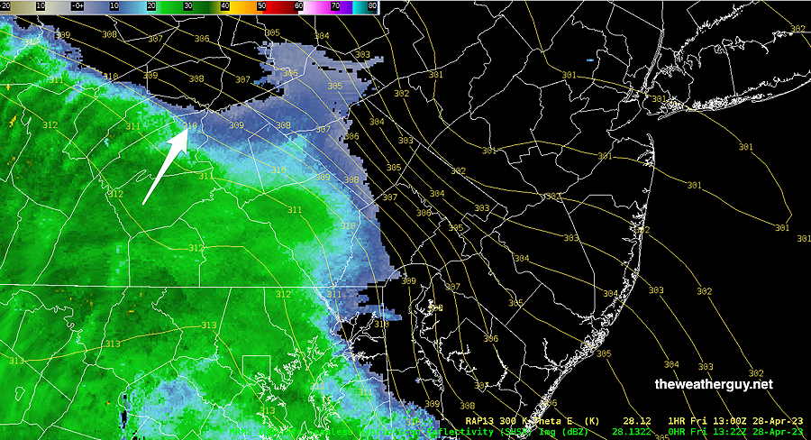
The models are still showing light sprinkles possible here about 11 AM, but the main area of rain moves in about 1-2 PM.


Rain: Parts of Friday, Saturday, Sunday

Update Thu 4/27 @ 9:08 PM — Several models have over two inches of rain falling Friday night alone.

Update Thu 04/27 @ 7:51 PM —The blocking pattern described below is setting up for this weekend and at least into Tuesday.

Rain moves in on Friday early afternoon, but some scattered sprinkles are possible during the morning.

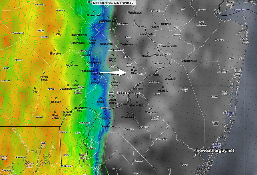
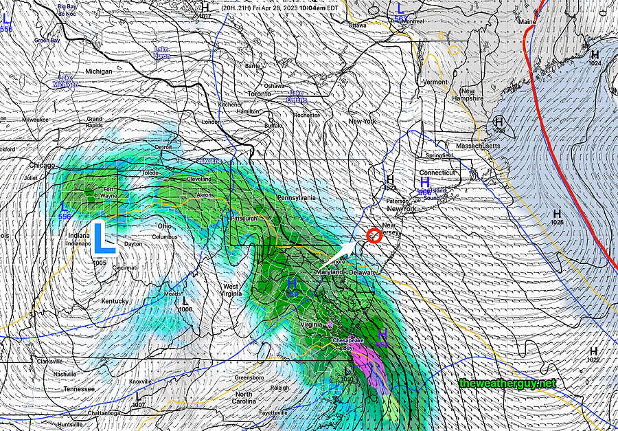
The main slug of rain moves in from the southwest around 11AM to 1PM according to the latest GFS model—

This afternoon’s 18z GFS model forecast for 10 AM Friday. (Click on image for a larger view.)

On Friday, once the rain starts, it will become moderate to heavy at times.

The bulk of the rain will be departing on Saturday morning, but the models maintain some scattered showers around during the day, especially northeast of our area.

Heavier rain moves in on Sunday.

This weather will be generated by circulation around a upper level closed low pressure system near the Great Lakes that will remain almost stationary. Timing the breaks in the rain will be challenging as the impulses circulating the low are tough to model exactly.

We may get enough of a break Saturday afternoon to salvage the day.

Sunday doesn’t look as promising at this time.

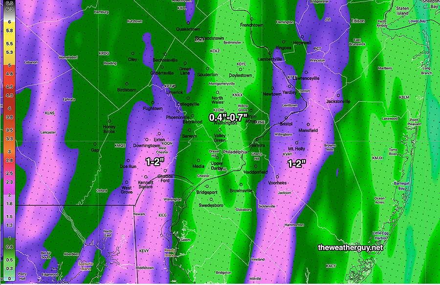
Total rainfall may exceed 2 inches for the weekend.

I’ll try to nail it down in my regular Weekend Weather Forecast.


Update Thu 04/27 @ 10:01 AM — Updated Thursday forecast here.


Previously Posted Wed 5:24 PM —

Developing Omega Block Pattern

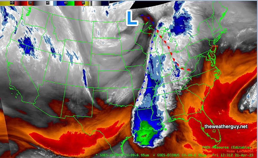
The upper air flow is moving towards a blocked pattern, specifically an “Omega Block” pattern. Unlike the recent “Rex” block named for the meteorologist who identified it, the “Omega” block is named for the Greek letter omega Ω because the wind flow resembles this letter.

Here’s the jet stream wind flow (at level 250 mb) for late Sunday. The Omega Ω resemblance is clearly visible—

Today’s GEFS 12z shows the forecast jet stream level (250 mb) wind flow for late Sunday resembling the greek letter Omega. (Click on image for a larger view.)

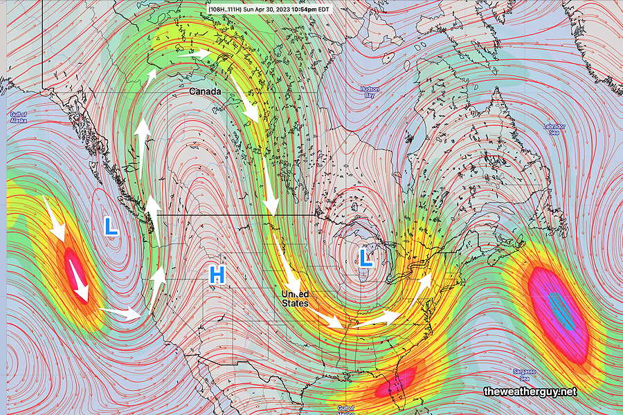
All blocked patterns result in stalled or slowly moving systems. In this case, we’ll be stalled in a cool, wet, cyclonic pattern with a closed upper low over the Great Lakes rotating disturbances towards us.

The developing block will bring rain to us by Friday afternoon. Periods of rain will be with us through the weekend and even through next Tuesday! There will be breaks in the rain and timing these breaks will be the challenge for this weekend’s forecast. It’s going to be a good weekend for ducks and flowers.

Rest of this week
Thursday

Update Thu 04/27 @ 10:02 AM — The latest HRRR forecasts even more lingering cloudiness today. We may not see any sun in the city until after 2 PM.

This morning’s 12z HRRR cloud forecast (Click on image for a larger view.)

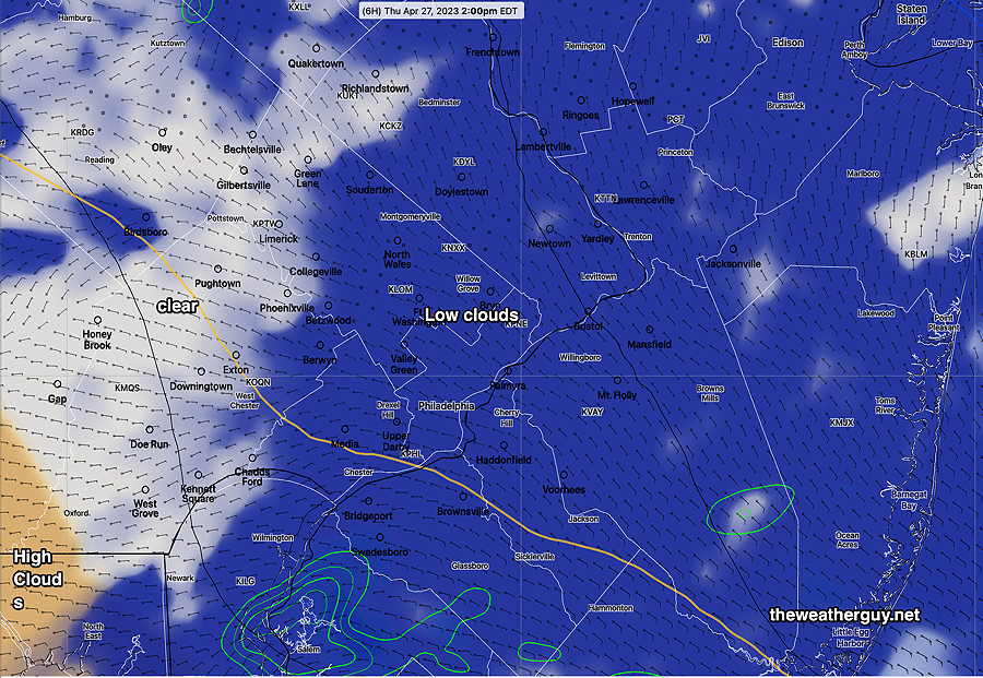
Update Thu 04/27 @ 8:35 AM — It looks like we’ll get some sunshine about 1 PM in the city and earlier west of the city. Clouds move back in about 6 PM. High temperatures about 61º but a high standard deviation of 3.5º based on the uncertainty in the cloud cover.


Update Wed 4/26 11:06 PM — Tonight’s models have clouds and light sprinkles lingering possibly past noon.


Before we get to this pattern, Thursday should start cloudy, but considerable sunshine expected around noon. A mix of sun and clouds for the afternoon. High will be near 65º

Friday

Friday will be cloudy and rain moves in about 2-4 PM from the west.


WEEKEND WEATHER FORECAST

#weather #paweather #wx #pawx #philadelphia #phillywx

Update Sat 04/22 @ 5:11 PM — The storms are moving in somewhat ahead of schedule of the HRRR and RAP models—

RADAR at 5PM Blue contours are “lapse rates”, areas of greatest thermal instability. Bullseye over eastern Bucks county, the strongest storms may develop there. (Click on image for a larger view.)

The Phillies game may just finish ahead of the storms. It’s going to be close.


Update Sat 04/22 @ 10:18 AM — The latest 12z NBM, HRRR, RAP and NAM-NEST models have become available.

Here’s the trends. Storms move in between 6 PM (western suburbs areas) and 8 PM.

Heaviest rain in western suburbs and in New Jersey. The immediate PHL area appears to fall into a lull in activity of the storms.

Heaviest rain—

12z HRRR total rain accumulation. This corresponds well with the greatest chance of severe weather. The ‘lull’ in activity around PHL shows. It should be noted that forecasts of exact placement of the heaviest rains are not possible with the current state of the models. It’s provided to give a sense that these storms will not have very uniform in coverage and intensity. (Click on image for a larger view.)

As for severity, below is my HRRR Severity Table—

Based on this table, I see tonight’s storms as typical thunderstorms with a chance of locally severe.

I don’t see tornadoes as likely. Largest hazard will be possible localized hail and strong straight line wind gusts.

I should indicate that the latest NAM-NEST has much higher CAPE and helicity values than the HRRR. I’ve found that the HRRR is more reliable for these sort of events and I’m going to ignore the more severe NAM-NEST forecast at this time.

Sept 1 , 2021
Tornado Outbreak
(example of highly severe)
Past
April 1st 2023 Tornado
Outbreak
HRRR 12z
Today’s
12z HRRR Forecast
Impact
CAPE 3500-4200 Joules/kg2100 550⚐ ⇩
Helicity 1350 m^2/s^2655460 ⚐ ⇩
Vertical Shear 40-4640-4525 ⚐ ⇩⇩
Precipitable Water 2.7″0.83”1.1″
Lifted Index minus 6º Kminus 9.3ºminus 2.3↓ ↓
HRRR Hail Parameter 1.91.41.3
Peak Wind Gusts 40-5040-5035-40
Aligned Storm Motion and Shear Vectors- ~ 90ºAlmost alignednon-aligned
Jet stream level – wavyHighly cyclonicwavy⚐ ⇩
Jet Stream 250 mb Speed – 63High 13594-100⚐ ⇩
Severity Parameters Impact: ⚑ indicates strongly favors Severity
⚐ indicates Possible Severity
↓ indicates works against Severity ⇩ Significant, but less impact

Update Sat 4/22 @ 8:09 AM — Quick update. Last night’s models show the following trends: A further increase in CAPE and some areas of moderate helicity, especially in Delaware and areas north of Trenton. Some areas with strong to severe storms now appears possible.

The line of storms moves in between 6 PM and 8 PM, about an hour or so later than forecast last night. (Earlier in western suburbs.)

I’ll update later this morning before 10:30 AM with this morning’s 12z models.


Update Fri 4/21 9:52 PM — With tonight’s HRRR just becoming available, I want to underline the possibility of a one or two widely scattered pop up storms during the mid afternoon due to increased instability.
The timing of the main line of rain and storms is mostly unchanged. The HRRR also shows a modest increase in severity parameters. Updates tomorrow morning after 10:15 with the new HRRR and NAM-NEST.


Previously Posted Fri 7:55 PM —

A strong cold front will move quickly through our area Saturday night with showers and possibly some thunderstorms. Cooler high pressure builds in for Sunday. (Average highs this time of year are 66º-67º)

Satellite water vapor shows the position of the front and upper level low this morning—

Water Vapor image shows upper low and position of the cold front from this morning. (Click on image for a larger view.)

Saturday

The clouds associated with the approaching cold front will move in during the early afternoon. Thickening clouds by 4 PM. It will become fairly windy and gusty in the afternoon.

It is possible that a few stray sprinkles may break out during the mid afternoon, ahead of the main line.

The main line of showers and possibly some thunderstorms moves in between 5 and 6 PM, earlier far western suburbs. Wind gusts near 30 mph. Greatest coverage of thunderstorms- western Chester County. Severity parameters are only in the moderate range.

Today’s 21z HREF Simulated Radar Forecast for6 PM Saturday. (Black-grey is cloud cover) (Click on image for a larger view.)

While any thunderstorm can produce locally heavy rain and strong wind gusts, no extreme weather is expected with these storms at this time.

NBM Wind/Gusts Forecast—

NBM wind and wind gust forecast Blue Bell, PA (Click on image for a larger view.)

The line of showers and storms will be fast moving and precip should end about 2 AM. Total rainfall about 0.5 -1”, greatest amounts in far western suburbs.

High temperature 77º sd 1º ( NBM model location Blue Bell, PA)

Sunday

Becoming sunny and breezy.

High temperature 64º sd 3º ( NBM model location Blue Bell, PA)


WEEKEND WEATHER FORECAST

#weather #paweather #wx #pawx #philadelphia #phillywx

Sunday Forecast Update

Update Sat 4/15 10:00 PM — Lingering clouds Sunday morning, breaking for periods of sunshine and clouds by late morning or early afternoon. Clouds move in towards evening and showers expected with a cold front after midnight. High temperature 78° but we may reach 80° with enough sunshine. Noticeably cooler Monday.


Update Sat 4/15 5:56 PM — Many areas did not receive any rain or storms today. The models are never able to predict exactly where storms will form and scenarios like today’s where the forecast is contingent on the position and track of an upper air low often result in the least exact precipitation placement forecasts.

Here’s what was happening at 5 PM—

Update Sat 04/15 @ 11:46 AM — It should be apparent that today’s weather is not going as forecast. The position and track of the upper air low is further north and west of what was forecast yesterday. As a result, the lcoation and timing of the showers and thunderstorms will be different than forecast. Current trends suggest that the heaviest showers and thunderstorms will be further north of our area. In fact, the precip in the immediate PHL area is looking fairly light.


Update Fri 04/14 @ 10:01 PM — The latest HRRR has become available and it gives a good idea about the scattered nature of the rain tomorrow and expected accumulations—

Friday night’s 00z HRRR accumulated rain by 8 PM. (Click on image for a larger view.)

Effective today, Twitter will no longer accept auto-posting from WordPress blogs like mine. I suggest Mastodon and the link on this page going forward.

Previously Posted Fri 9:04 PM —

Saturday Forecast

As mentioned in this morning’s update, the upper low that been bringing heavy rain to the southeastern US will be moving directly over Pennsylvania on Saturday. Showers and thunderstorms are expected as early as the mid morning hours Saturday and showers and thunderstorms will become more widespread during the afternoon hours.

Any storms are NOT expected to be severe, but localized moderate to heavy rain is possible for some locations. The exact locations depends upon the location of the upper low’s circulation, something the models aren’t perfect at doing.

The new NBM model v4.1 has a new forecast parameter, “thunderstorm coverage”. Here’s the NBM’s prediction for the greatest density of thunderstorm coverage tomorrow—

NBM 21z forecast “thunderstorm coverage” at 4 PM Saturday Greatest amount of thunderstorm activity in dark purple, but all areas especially north and west of the city have some possibility of thunderstorms. (Click on image for a larger view.)

High temperature on Saturday 72º sd 2.2ª (Blue Bell, PA)

Sunday

As for Sunday, clouds lingering in the morning. Some sunshine by afternoon.