Posted Sunday 05/11/25 @ 9:40 AM — A beautiful Mother’s Day. The weather couldn’t be finer. Light winds, low humidity. Highs near or above 80º
05-11-25 12zNBM forecast high temperatures for Sunday (Click on image for a larger view.)
Enjoy the great weather today, because the AI models are forecasting several days of rain, potentially heavy, from before daybreak Tuesday through Friday.
Clouds move in during the afternoon Monday and rain begins shortly after midnight early Tuesday morning.
Posted Saturday 05/10/25 @ 9:22 AM — Enjoy this wonderful (but somewhat cool and, initially, rather windy) weather that we’ll have through Monday. The models are consistently forecasting rainy weather from before daybreak Tuesday through early Thursday—
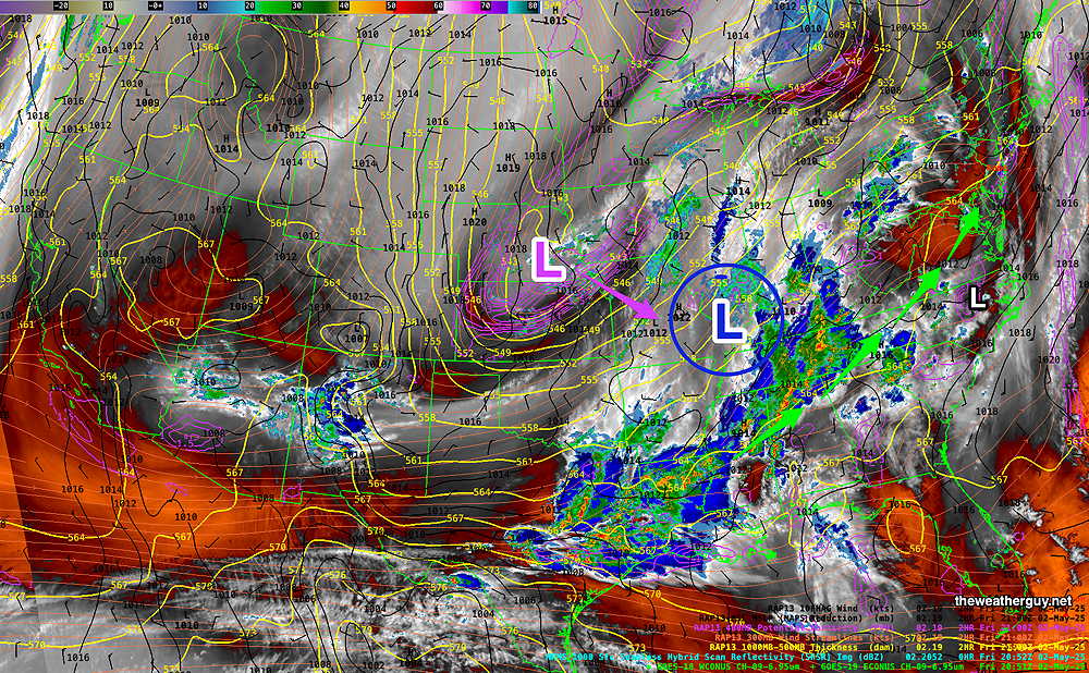
06zECMWF-AI Single forecast for Tuesday at 8 AM. A slow moving system associated with another closed upper level low (Blue L) will move in before daybreak Tuesday. (Click on image for a larger view.)
Previously Posted Fri @ 5:33 PM — —Low pressure that gave us the rain on Friday will depart Friday night. High pressure builds in on Saturday. The pressure gradient between the departing low and the building high will cause windy conditions on Saturday.
NAEFS forecast for Saturday at 2 AM. High pressure will be in play over the weekend, keeping the developing low pressure system near the Gulf of Mexico Gulf of America Gulf of Mexico to be suppressed to our south. (Click on image for a larger view.)
Saturday Forecast
Sunny and windy.
NBM Winds and gusts
NBM high temperatures: Blue Bell, PA 71º Philadelphia, PA73º Uncertainty (based on standard deviation) : above average ±2º
Sunday Forecast
Sunny and less windy.
NBM high temperatures: Blue Bell, PA 75º Philadelphia, PA 78º Uncertainty (based on standard deviation): above average ±2º
Posted Sunday 05/04/25 @ 9:40 AM — So far, the rain from this closed upper level low has not played out as forecast. Following the rain/thunderstorms last evening that just clipped the Phillies game, there hadn’t been much additional rain.
Some rain redeveloped this morning, just clipping the Broad Street Run, which wasn’t accurately predicted by any model.
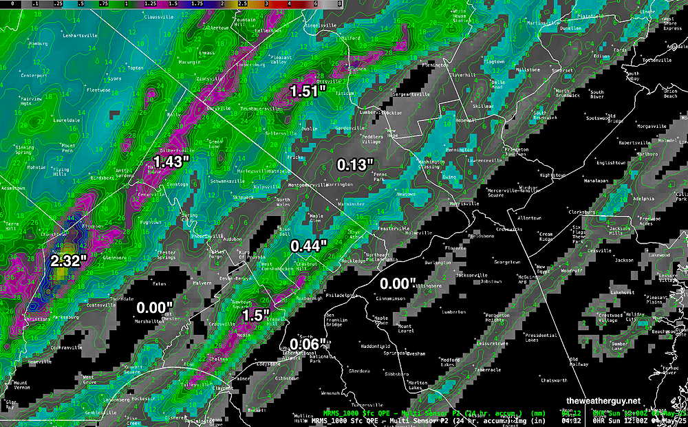
Here’s the amount of rainfall from last night—
MRMS rain-gauge measured rainfall combined with rain-gauge calibrated and interpolated radar-based summary of ACTUAL RAINFALL RECEIVED. Color shading is in inches. Line contour numbers are in mm. (25.4 mm= 1 inch) 24 hour totals. It seems that the number is a bit low for the area around Citizen’s Bank Park. (Click on image for a larger view.)
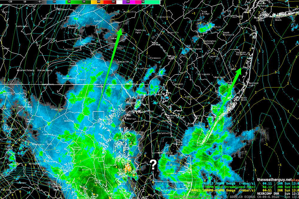
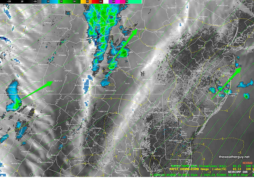
Currently two bands of rain exist, west and east of the city—
Composite Radar with superimposed RAP model 700 mb (10,000 ft) wind streams (green lines) and Omega (vertical velocity) low level and high level. The Positive Omega area (?) may induce more showers. (Click on image for a larger view.)
The latest RRFS is a good match for the current radar. It has more storms moving through 2=5 PM—
06z RRFS forecast for 5 PM (Click on image for a larger view.)
The models often correctly predict the overall general pattern with closed upper lows, but it’s also common for the details regarding rain banding and timing to be not very accurate.
Forecast Update
Posted Saturday 05/03/25 @ 5:39 PM — Some fast moving isolated storms are developing just west of the city and in NJ, in areas having the greatest CAPE value. It’s a close call, but this evening’s storm development may remain away from Citizens Bank Park this evening.
Latest hourly RRFS forecast for 9 PM tonight (Click on image for a larger view.)
Some rain will likely move in later this, with the heaviest precipitation still just west of the immediate Philadelphia area.
For the Broad Street Run, the models still keep a relatively rain-free period from 7 AM Sunday through about 11 PM. Rain then moves in from the south, with the heaviest bands again just west of the city.
Still A Difficult Forecast
Posted Saturday 05/03/25 @ 10:26 AM — The effect of the upper low has yet to affect the Philadelphia area. The upper winds are still anti-cyclonic in curvature, inhibiting rainfall. This morning, I’ve waited to see the latest models to post this forecast.
Here’s the latest water vapor image showing most of the immediate area rain free and no obvious triggers downstream—
Water Vapor with superimposed radar 700 mb wind streams and low level Omega (Click on image for a larger view.)
This morning’s NAM-NEST, HRRR and RRFS keep any showers/storms to our far west, with sunshine through cirrus clouds for much of the day. Showers move eastward, just reaching the immediate Philadelphia area by late evening.
On the otherhand, the ECMWF-AI model along with the ECMWF and GFS have showers/storms moving in during the late afternoon and somewhat heavy activity this evening.
Here’s the GFS with showing rain developing as early as 5 PM—
06z GFS forecast for 5 PM Saturday
A difficult forecast with such wide differences in model guidance. The AI model has been most consistent and the closest to reality, so I’m leaning towards its forecast of showers developing here late afternoon.
As for Sunday’s Broad Street Run, the models suggest a break in the rain from 7 AM to 11 AM, but heavier rain moves in from the south by 11 AM to noon. I’ll update later this afternoon.
Includes forecast for Sunday’s Broad Street Run
Previously Posted Fri @ 5:34 PM — —The much advertised cut off upper level low takes shape late Saturday and will continue to affect our weather through Monday and possibly Tuesday.
The initial slug of energy is dropping south at this time and will close off as an upper level low over the Ohio/Mississippi Valleys.
Current satellite water vapor image with superimposed RAP model 500-1000 mb thickness lines (yellow), Mean Sea Level Pressure isobars (black contours) potential vorticity (fine violet contours) with superimposed MRMS RADAR. Potential Energy (violet contours) will continue to drop south and a closed upper low (Blue L) will develop by later Saturday. A secondary surface low developing around Maryland will bring showers and thunderstorms Saturday evening to our area. Moisture from the south will continue to bring showers and thunderstorms through Sunday. (Click on image for a larger view.)
A secondary surface low developing around Maryland will bring showers and thunderstorms Saturday evening into early Sunday morning.
The exact position of the upper low will determine if we are in the heavy rain bands expected to develop. The final position is not a certainty.
Some widely scattered showers and thunderstorms are breaking out a this time (Friday late afternoon) and there are indications that additional scattered showers/storms may develop this evening. Not all areas will see rain tonight.
Saturday Forecast
Depending on the model, rain and shower may begin as early as 2 PM around Philadelphia, but rain and thunderstorms look definite by Saturday evening.
NBM high temperatures: Blue Bell, PA 86º Philadelphia, PA 87º Uncertainty (based on standard deviation): low ± 1.4º
Sunday Forecast
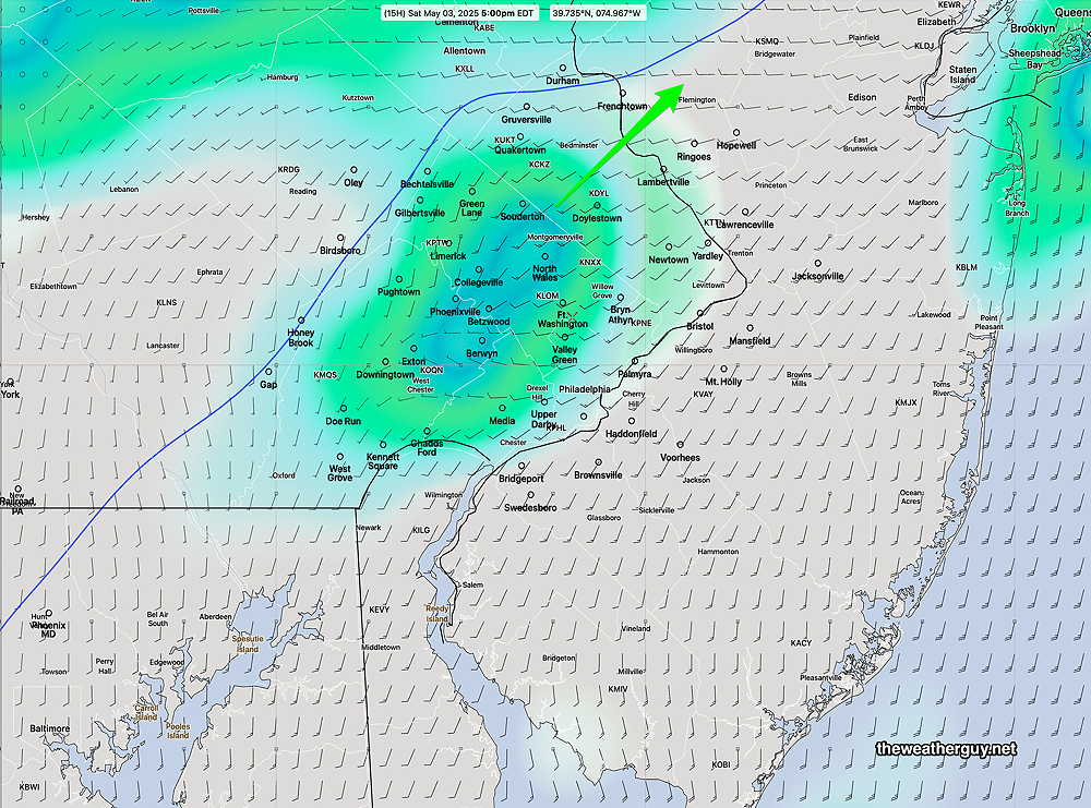
Rain tapers off around daybreak Sunday, leaving the morning hours potentially rain-free or just light drizzle, but additional ran is expected to develop around noon into the afternoon.
NBM hourly rainfall for 8 AM Sunday. Scattered very light drizzle, less than 0.01″. Heavier precipitation to our west. (Click on image for a larger view.)
NBM high temperatures: Blue Bell, PA 75º Philadelphia, PA 78º Uncertainty (based on standard deviation): average ± 2.4º
Center City: Winds light- moderate (8 mph) with gusts to 12 mph from the SE. Increasing during the afternoon hours.
Potentially accumulation 1-2 inches of rain is possible by Tuesday with locally higher amounts.
Sat 7:50 PM —Forecast Review —There was quite a range in rainfall totals for Saturday. As is almost always the case, the models rarely forecast the heavier banding of rainfall in a way that way that closely resembles reality.
Here’s what the MRMS rainfall summary shows—
MRMS rain-gauge measured rainfall combined with rain-gauge calibrated and interpolated radar-based summary of ACTUAL RAINFALL RECEIVED. Color shading is in inches. Line contour numbers are in mm. (25.4 mm= 1 inch) (Click on image for a larger view.)
Rainfall totals today did little to reduce the current deficit. A hot, dry summer remains a strong possibility.
Saturday Forecast Update
Posted Saturday 04/26/25 @ 9:34 AM — As forecast, “some bright spots and even some sunshine” has already developed. (The models often don’t show this following a warm front passage.) That said, it will still be difficult to forecast a specific time period today where we’ll definitely be rain-free, since the models shows scattered showers and storms in different locations at different times throughout the day.
The most likely time for somewhat organized rainfall will be with the cold front, still forecast to occur between 3 PM and 7 PM. Here’s the latest REFS (experimental) forecast for 6 PM—
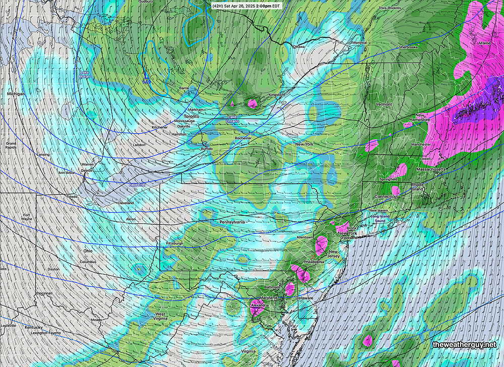
06z REFS combined rain (plus statistical spread) at 7 PM. The experimental REFS is a statistical model that uses the experimental RRFS and combines it with time-lagged HRRR model forecasts to create a group of models, allowing a statistical analysis. The group of models is called an ensemble. Standard deviation (statiscal spread) can be calculated from this group of models. (Click on image for a larger view.)06z REFS total rainfall forecast. Hardly a drought buster. (Click on image for a larger view.)
Not much rainfall expected with this system and certainly less than the 1.4″ the much-touted regular ECMWF was forecasting two days ago. (The ECMWF-AI did much better with a forecast of 0.52″ or less.)
Any prolonged sunshine this afternoon (still a possibility) may result in heavier thunderstorms and more localized rainfall.
Saturday Forecast Update
Posted Friday 04/25/25 @ 5:10 PM — There’s greater agreement among the models regarding the total rainfall. Most have between 0.5″ and 1.0″ of rain with the majority of the immediate PHL area seeing only the 0.5″ amount. Not really the soaking that was talked about.
Many models are showing scattered showers with possibly some thunder tonight, as early as 11 PM with the warm front. Rain tapers off about 8 AM Saturday morning, but there’s an increasing chance of more showers and possibly some thunderstorms again from noon to 8 PM.
It would not surprise me if we see some bright spots and even some sunshine at times during the day. But, it’s difficult to pinpoint any definite lull in the action. There will be lulls several times during the day.
The ECMWF and ECMWF-AI have showers lasting until 8-10 PM, while the NAM-NEST and experimental RRFS/REFS have the precipitation ending earlier with the final line of storms moving through between 3 PM and 7 PM. Some of the thunderstorms may be strong (but not severe.)
12z RRFS (experimental) rain/radar at 6 PM (Click on image for a larger view.)
Early Edition
Posted Friday 04/25/25 @ 8:51 AM —The forecast for today, Friday as well as Saturday, has a bit more uncertainty from yesterday’s posting regarding the timing of the rain and thunderstorms, as well as the amount of rainfall in our immediate area.
An associated warm front and cold front of a low pressure system will pass through our area later tonight and through Saturday.
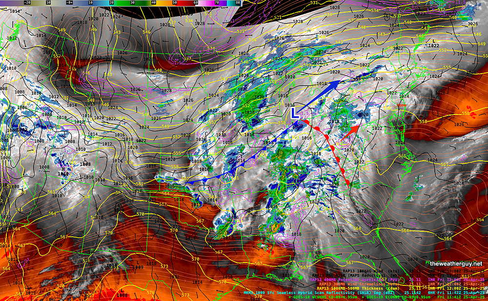
Current satellite water vapor image (8 AM Friday) with superimposed RAP model 500-1000 mb thickness lines (yellow), Mean Sea Level Pressure isobars (black contours) potential vorticity (fine violet contours) with superimposed MRMS RADAR. (Click on image for a larger view.)
It appears that more cloudiness this afternoon is likely, compared to yesterday’s forecast. Light rain is possible this evening, according to the latest ECMWF-AI model and the experimental REFS. So the system is approaching faster than previous forecasts.
Showers persist Saturday morning, but it’s likely we’ll see some bright spots or even some sun before the cold front moves through with more showers and thunderstorms.
Yesterday’s forecast had the cold front moving through about 2-3 PM Saturday with rapid clearing by evening.
Today’s forecast has Saturday‘s rain/thunderstorms somewhat later, between 3 PM and 7 PM, (although the ECMWF shows showers with the cold front as early as 1-2 PM) and lingering into the evening hours as the cold front sharpens and intensifies as it moves through. So we may still have some showers as late as 8-9 PM. Saturday will also be quite windy! So the timing of the heavier rain/thunder on Saturday is “up in the air”.
Regular ECMWF model prior 3 hour rain forecast at 2 PM Saturday. (Click on image for a larger view.)
Sunday looks partly to mostly sunny and fairly windy. (The experimental RRFS-A shows periods of instability cloudiness with less sunshine. Sunday’s highs low to mid 60s