Category Archives: Philadelphia Area Weather Forecasts

Unsettled Weather for this Weekend

The low pressure system that brought the heavy rains to Philadelphia this morning will gradually move northeastward, as a sharp upper air trough digs down over our area.  The sharp upper trough will “pinch off” into a closed upper low pressure system by Tuesday and will be centered over the northeast. The developing closed upper low pressure system will result in very cool weather Monday into Tuesday.

Upper air lows are notoriously difficult to model, especially regarding amounts of sun vs. cloudiness and precipitation, so this forecast is a bit below average confidence. 

For Saturday, the low pressure system and cyclonic flow in the upper atmosphere will result in considerable low level cloudiness, after some early morning bright spots.  It will be breezy and mild; temperatures will reach a high of about 69.

A weak cold front approaches late Saturday afternoon with the possibility of light scattered showers. The cold front moves through early Sunday morning.

Following the frontal passage, Sunday will be have a mix of sun and clouds.  With the cold, low pressure in the upper atmosphere, any sunshine will be “self-destructive”; heating from sunshine will result in more cloudiness due to the unstable thermal profile.   Temperatures will be cool on Sunday; Highs about 60.

Philly Weekend Weather Forecast

The weekend forecast seems to have changed somewhat over the past day or so.  (A dry warm weekend was originally forecast.)

A warm front is expected to move past our area early Saturday morning. Some showers and even a thunderstorm is possible early to mid Saturday morning.   Skies should break for partly sunny skies.  Highs around 85.

A weak cold front drops through the area later Saturday afternoon.  Another chance of showers and thunderstorms is possible late afternoon Saturday.  (I’ll look into this again on Saturday morning.)

On Sunday, an easterly flow develops, keeping our temperatures much cooler.  Some cloudiness is also expected yet it’s not certain how much cloudiness will result with this easterly flow.   Highs around 67.

Low Confidence Forecast for this weekend

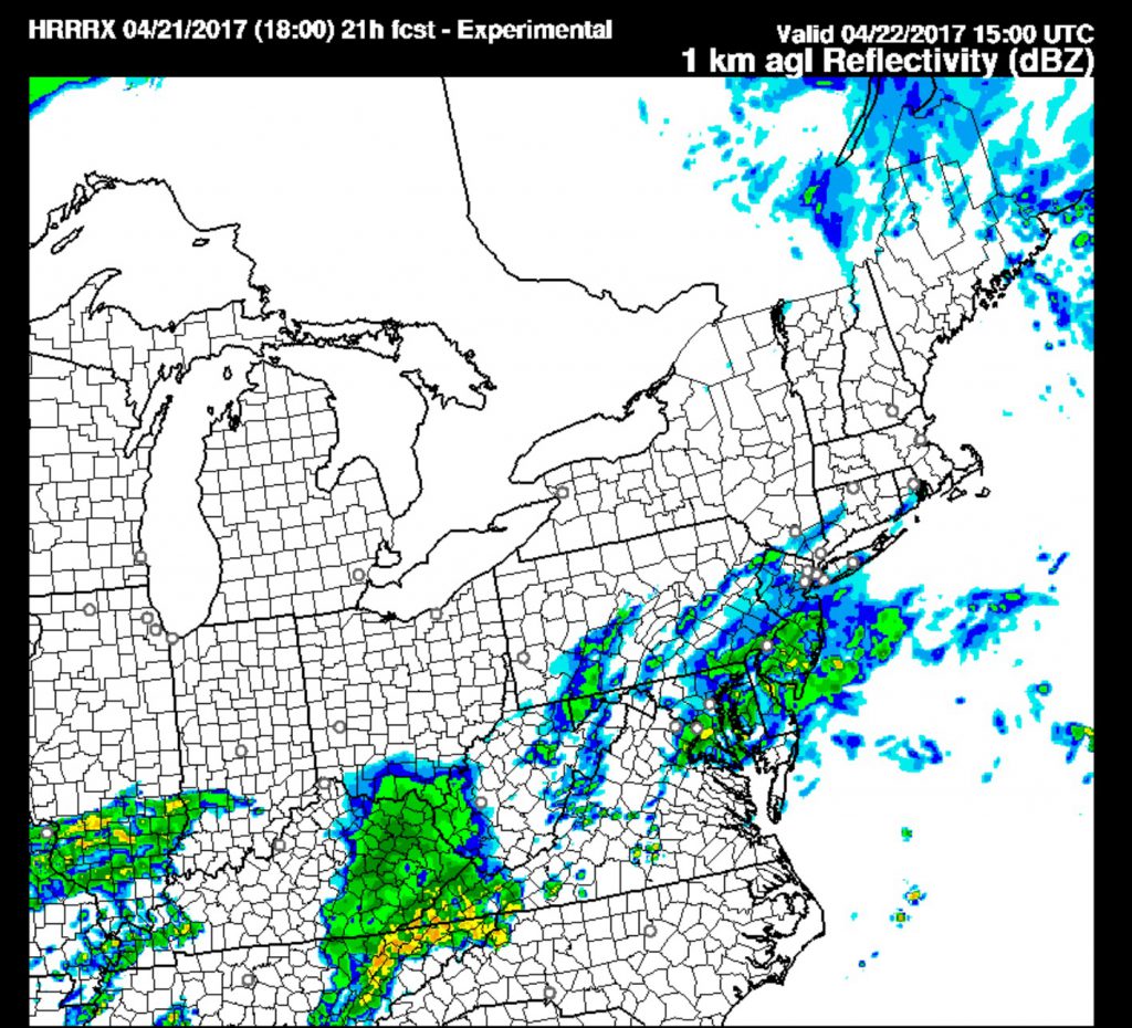
Friday evening update:  It’s looking like Saturday will be wet with showers moving in during the morning, based on the latest HRRR and nested NAM models.

Significant differences in the model forecasts makes this a tough forecast for the coming weekend.  The NAM and GFS models show low pressure moving eastward and to our south for Saturday; The NAM is stronger with this system and has rain moving in Saturday morning.  The GFS keeps the precipitation just to the south of Philadelphia for much of Saturday

In fact, there are significant differences between the GFS and the “Parallel GFS model” (The “Parallel GFS model” is a newer version of the GFS being developed and run “in parallel” to compare accuracy).

The Parallel GFS has the early part of Saturday dry and has some showers moving in later in the day.

This afternoon’s NAM run has moved in the direction of the GFS, with the precipitation suppressed just to the south of Philadephia.

It would not take much error for the forecast to be a bust in either direction.  So we’ll go with just cloudy (most likely) So we’ll go with showers for Saturday, starting in the morning and continuing into the afternoon.

but it might be wet if the rain shield moves as little as 30  miles north.  High 63.

HRRR forecast for Saturday morning. Is this correct??  Looks like it is.

Both models suppress the rain well to our south on Sunday.  Sunday will be dry, cloudy with some sunny breaks possible by afternoon.  High 65.

I’ll update later this evening if things clarify for Saturday.