An anomalously amplified upper air configuration will allow unseasonably cold air to infiltrate into our area Saturday and early Sunday.
Slight moderation in temperatures will occur on Sunday and Monday ahead of another even colder air mass that will affect us next Tuesday and Wednesday.
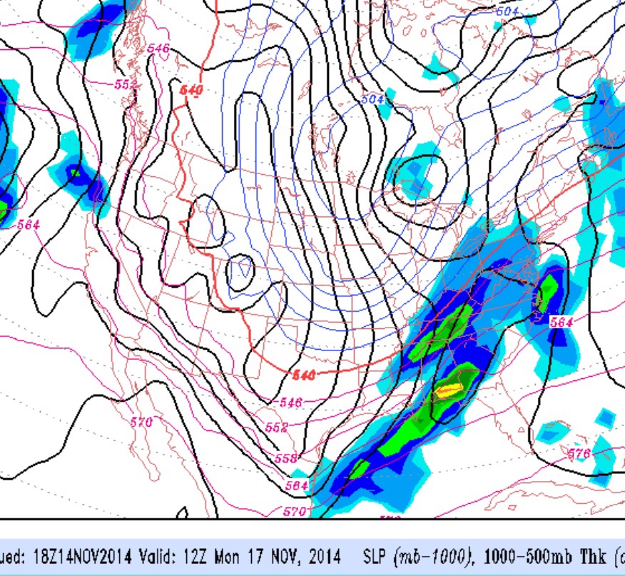
Preceding this polar front moving through Monday evening will be some cold rain that may also change to snow before ending late Monday evening, although the models are suggesting that the precipitation will end before the cold air aloft moves in.
Saturday will be sunny and cold with highs near 40.
Sunday will be cloudy with temperatures a bit warmer, around 46.
Heavy rain and cold temperatures will be with us Monday, with the polar front moving through late afternoon or early evening. Temperatures will plummet as the winds pick up from the northwest. Not looking like any snow at this time, but things can change.
The cold front is moving through this evening and the expected precipitation has turned to snow a bit earlier than expected.
An anomalous amplified upper air configuration will allow unseasonably cold air to infiltrate into our area Friday and Saturday.
Some moderation in temperatures will occur on Sunday and Monday ahead of another even colder air mass that will affect us next Tuesday and Wednesday. Preceding this polar front moving through Monday evening will be an some cold rain that may also change to snow before ending late Monday night.
Saturday will be sunny and cold with highs near 44.
Sunday wIll have increasing cloudiness with highs near 47
The recent national news has covered the highly amplified upper air configuration that’s bringing below average temperatures to the middle of the US. That deep dip in the jet will slowly advance eastward through Thursday, and temps will fall with highs in the 40s by Friday.
The models have been hinting at a weak coastal low that develops Thursday night as the cold air advances over us. The latest GFS model shows light snow possible for much of South Jersey and around the US 95 corridor late Thursday night into Friday morning. Accumulations will be light, if any.
Several other disturbances ride up the upper trough, both Sunday and next Monday into Tuesday, with chances of precipitation each time. Some of the precip will be in the form of light snow showers (Sunday) and a wet wintery mix Monday night. Stay tuned.