Disturbances moving along a somewhat stationary warm frontal boundary to our south will continue to affect our weather this weekend.
There won’t be much in the way of sunshine this weekend, as low clouds, rain, drizzle and thunderstorms will each make an appearance through Monday.
An easterly flow will develop ahead of a somewhat stationary warm front on Saturday. Some rain and showers will move through from the southwest before daybreak Saturday. There’s a range of model forecasts, but most have this rain somewhat heavy in the early morning, tapering off about 10 to 11 AM.
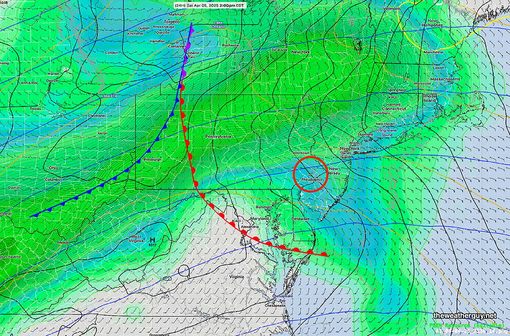
(If the warm front actually moves north of our area, we may see some slight clearing, but it appears the warm front will stay to our south. Below is the latest ECMWF-AI model—
ECMWF-AI Forecast for 2 PM Saturday. Rain lifting off to our northeast, but the front appears to be to our south. (Click on image for a larger view.)
It should be noted that the experimental RRFS, which resumed running this week, has most of this early morning activity well north of the immediate Philadelphia area. The NAM-NEST, the HRRR, and another experimental model, the MPAS, has the heavier rain right over Philadelphia early in the morning. It will also be windy in the morning.
Most models maintain low clouds, drizzle and even some fog for much of the day but especially late Saturday afternoon, after 4 PM and into the night.
Low pressure develops along the warm front to our south and lifts away on Sunday, shifting the winds to the north on Sunday as rain and even some thunderstorms in the early afternoon. Another low pressure system moves through along the stalled front from the west late Sunday afternoon with heavier rain into Monday.
Some of the timing of these features may change based on slight movement of the somewhat stationery front.
Posted Thursday 04/03/25 @ 4:32 PM — The warm front moved north of our area today, Thursday, allowing very mild and humid air to move into our region. The same air mass boundary will return tonight as a cold front.
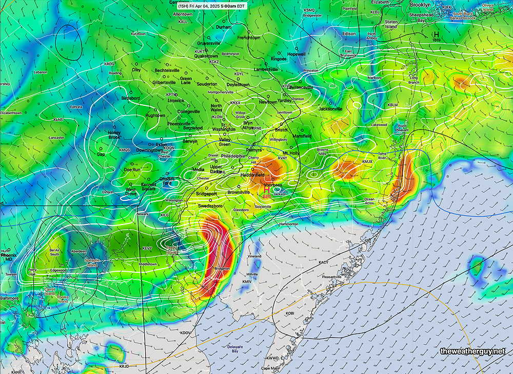
The air over us is unstable and there is will be enough CAPE, vertical wind shear and helicity to aid in the formation of some strong, possibly severe thunderstorms in the 2 AM -6 AM time frame. Some heavy rain is possible. Here’s the latest HRRR forecast—
18z HRRR simulated radar forecast for 5 AM Friday morning. Some very heavy thunderstorms in red. (Click on image for a larger view.)
Rain will continue through Friday morning, ending northwest to southeast during the early afternoon.
The same boundary will move north again as warm front on Saturday, with showers, thunderstorms possible late morning into Saturday afternoon.
Interesting Forecast
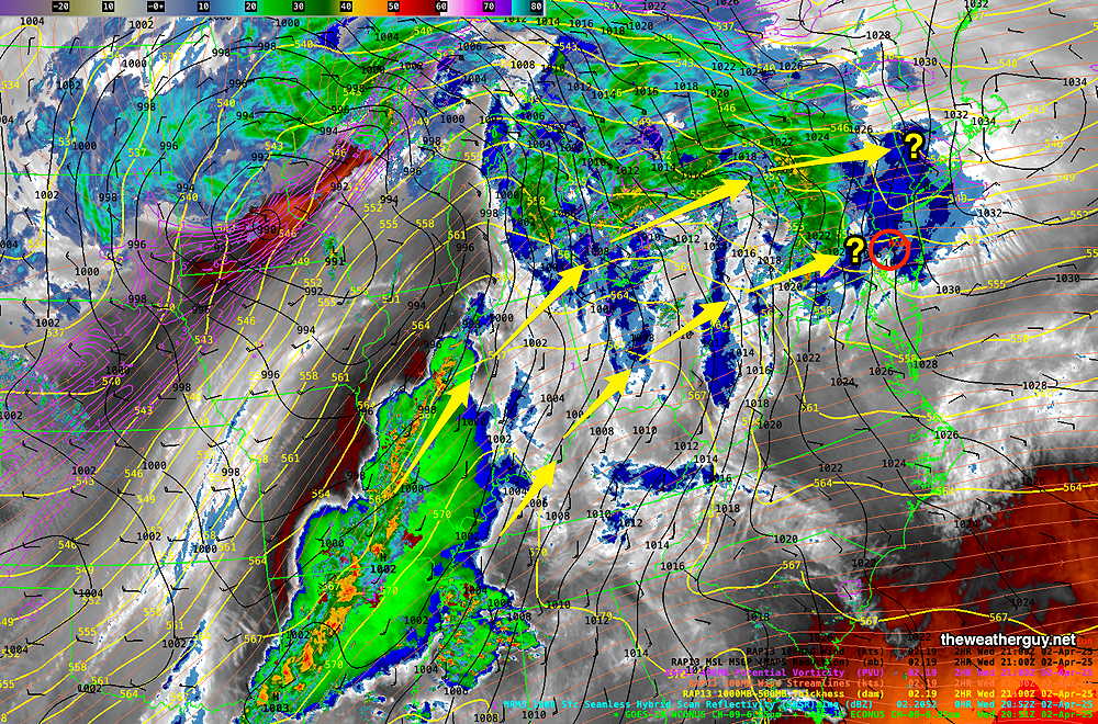
Posted Wednesday 04/02/25 @ 5:14 PM — The upcoming forecast period into the weekend will be interesting. The AI models are forecasting considerable rain in our area, while the regular numerical models are forecasting the axis of rain to be to our north. The current water vapor image illustrates this difference—
Current satellite water vapor image with superimposed RAP model 500-1000 mb thickness lines (yellow), Mean Sea Level Pressure isobars (black contours) potential vorticity (fine violet contours) with superimposed MRMS RADAR. There are two possible tracks for the expected stream of disturbances moving around the southeastern high pressure ridge. (Click on image for a larger view.)
The latest HRRR has moved towards some rain over our area Thursday associated with a warm front moving through later tonight. Most of the rain will be ending around 12 noon – 1 PM from the city and westward.
HRRR (18z) accumulated rain through 1PM Thursday (Click on image for a larger view.)
There may be breaks of sun mid afternoon, but overall it will mostly cloudy. A weak cold front moves through Thursday evening with more showers into Friday morning. Then there’s uncertainty. The AI model shows plenty of showers for Friday Saturday and Sunday. Will need to see if/how the models are coming together!
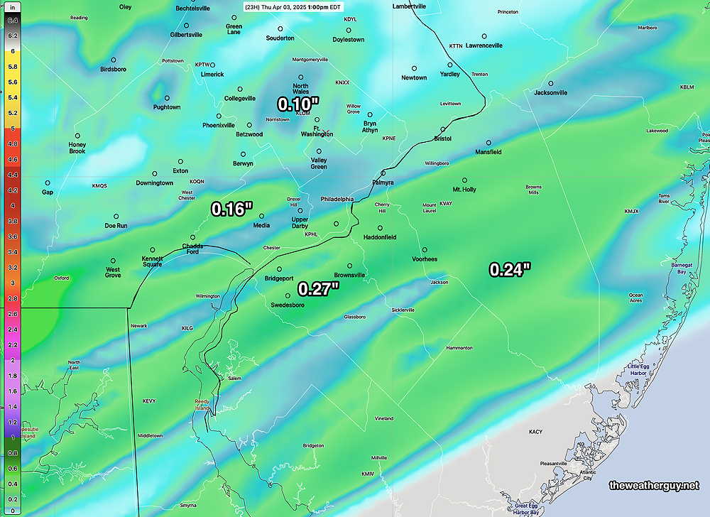
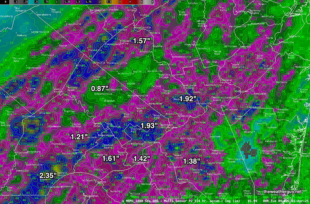
Wed 10:24 AM —Forecast Review — I just wanted to post the rain totals from Monday’s storms. Total (much needed) rainfall exceeded the model predictions.
MRMS rain-gauge measured rainfall combined with rain-gauge calibrated and interpolated radar-based summary of ACTUAL RAINFALL RECEIVED Monday March 31 into early Tuesday 4/1 . Color shading is in inches. Line contour numbers are in mm. (25.4 mm= 1 inch) (Click on image for a larger view.)
For part of this month of April, this blog’s weather updates will be less frequent than usual.
Monday Evening Storm Update
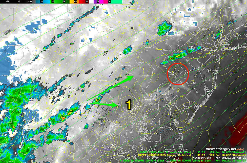
Posted Monday 03/31/25 @ 4:42 PM — No significant change from previous forecast update. Here’s the near-current water vapor/radar—
Water Vapor/Composite Radar with superimposed RAP model vertical velocity pressure (Omega- yellow contours) and horizontal moisture convergence (blue contours) and 700 mb wind streamlines. Area 1 shows enhanced upward vertical motion (positive Omega) , indicating intensification to occur. (Click on image for a larger view.)
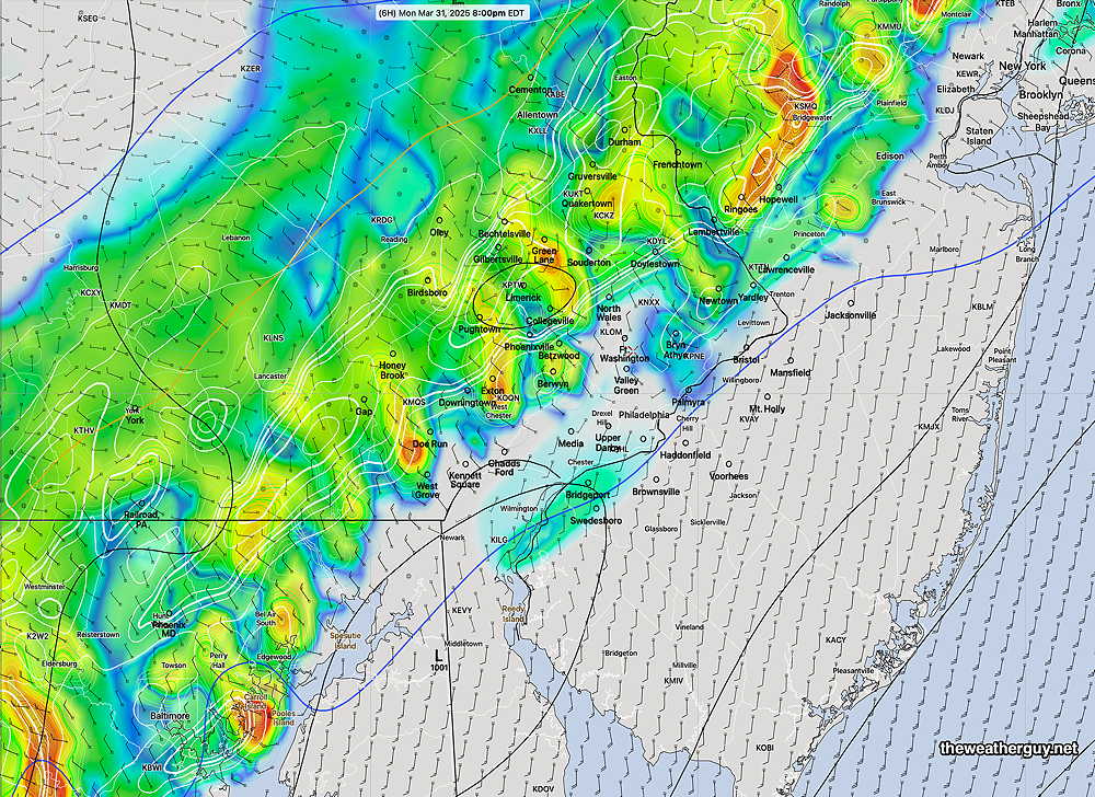
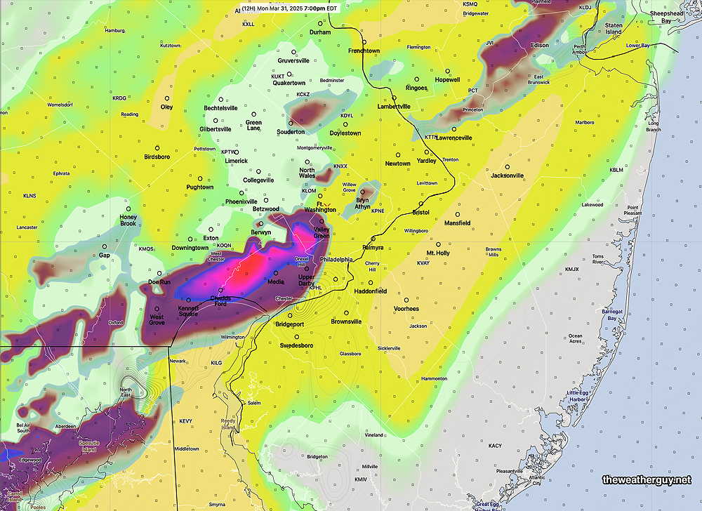
Here’s the latest HRRR forecast at 8 PM—
HRRR shows storms coalesce into a line with heavier cells at 8 PM (Click on image for a larger view.)
Monday Evening Possible Severe Weather
Posted Monday 03/31/25 @ 9:05 AM — A strong cold front approaches today and is expected to move through the Philadelphia area about 10 PM. Ahead of the front, unstable conditions will allow for the possibility of severe thunderstorms ahead of the front. The most likely timing is between 6 PM and 9 PM with a peak at 7-8 PM according to the latest HRRR.
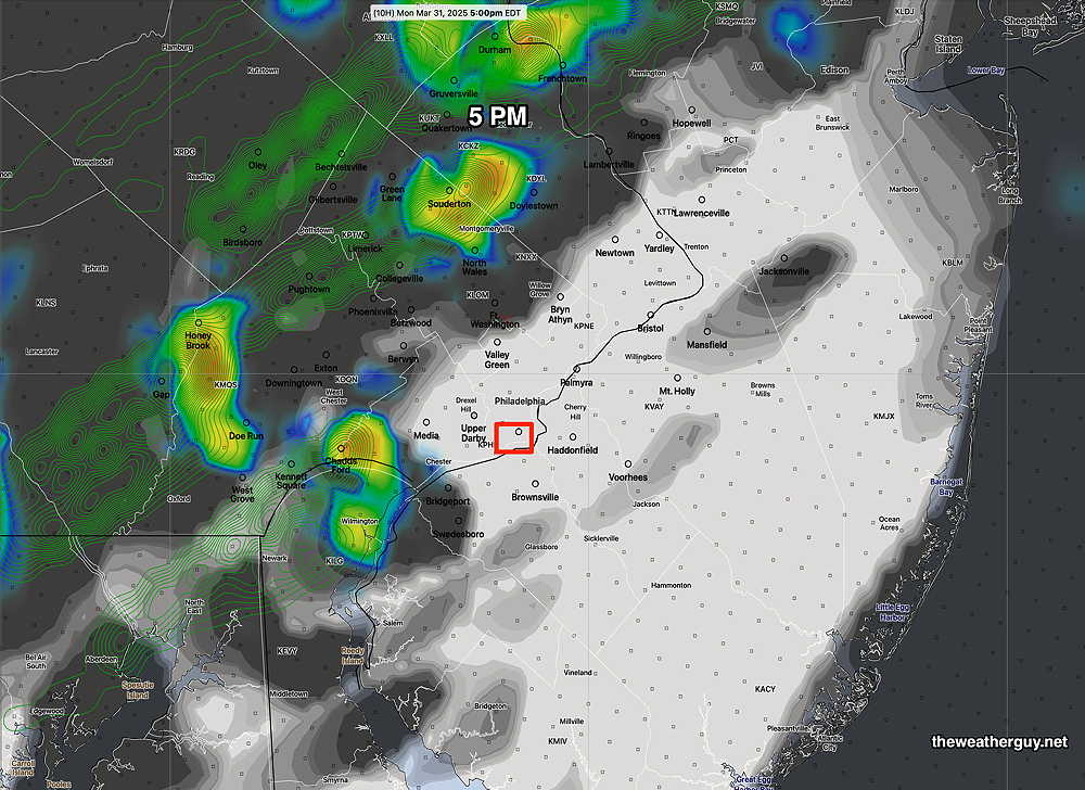
As for the Phillies opening game at 3 PM, most models keep any storms to the western suburbs, but the latest HRRR does show some possible activity closer to the city at 5 PM—
11z HRRR simulated radar and clouds forecast at 5 PM (Click on image for a larger view.)
As mentioned, there’s the potential for severe weather, especially this evening. The HRRR shows areas of highly elevated severe weather parameters (vertical shear, helicity and upward helicity) approaching the city about 7 PM—
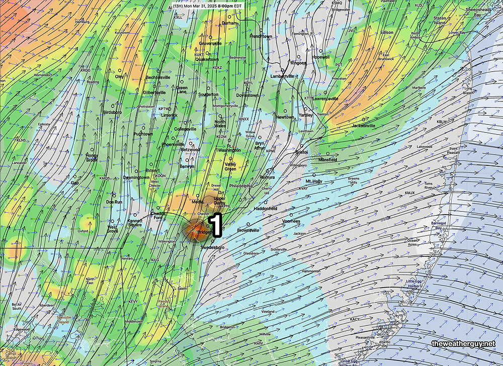
It should be noted that a high shear and helicity forecast at 8 PM shows possible low tornadic potential—
High helicity and vertical shear at 8 PM (1) shows low potential of tornadic activity. (Click on image for a larger view.)
As always, the model placement for the potential severe weather is rarely exactly where it will occur. (It’s only a model.) But the potential and general timing is what’s important.