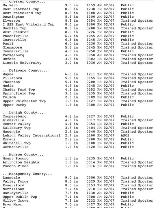
Final snow totals can be seen here.

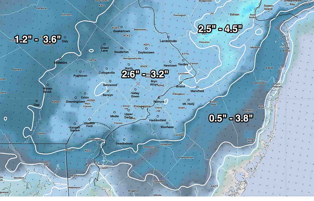
Every storm is different and a learning experience. The Model Blend (NBM) is supposed to do all the heavy lifting for a forecast, but it hasn’t been too good at blending or there’s bad info going into the blender.)
One more thing. Official Final Snow totals DO include compaction. (We have 4 inches at 12:24 PM.) If you shovel away 3″ of snow and you measure another 3″, the total snowfall isn’t necessarily 3+3=6. Official snow totals are measured immediately after the snow stops and the model algorithms assume compaction based on PTYPE, temperature, density.
Oh…one more thing. I didn’t follow my own axiom that I had shared earlier this week… “it’s never good to ignore the NAM model”
Forecast Updated Sun 11:20 AM — We have an interesting comment from Downingtown that they have gotten six inches on metal surfaces, 4 inches on driveway.
The latest GFS model run from 7 AM just became available at 10:38. Incredibly, it only show 4.3 inches of snow (for Downingtown!). Here, I have about 3.0-3.5 inches at 11 AM.
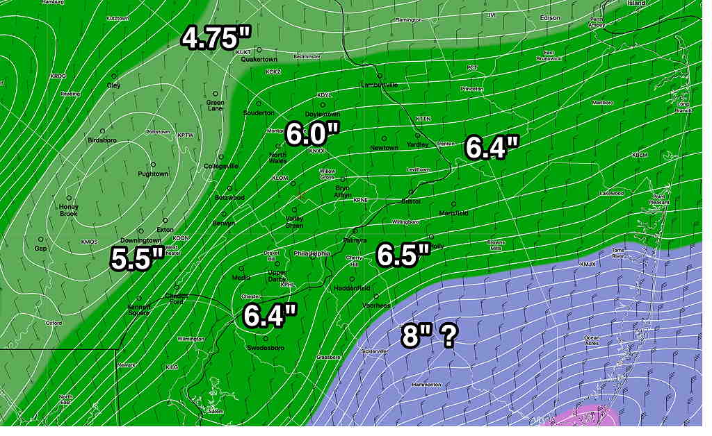
Only the NAM has (may have) gotten this right, with about 5-6 total inches consistently forecast for the PHL area. While I mentioned the NAM model’s higher totals each previous post, I discounted it in favor of the NBM. It’s all a learning experience. (Interestingly, the NAM had much more sleet and much less snow during our last 48 hour storm. Go figure!)
The latest hourly HRRR has snow ending about 3 PM ± 1 hour.
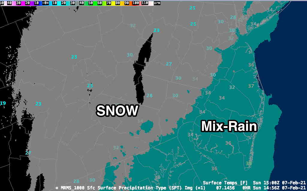
Forecast Updated Sun 9:33 AM — This morning’s models have become available. The main heavier axis of precip (rain/snow) has shifted east into NJ. The complicating issue in predicting snow accumulation is that the temperatures in NJ for the heaviest snow are forecast to be 35º and some precip will mix with rain in NJ.
Temperatures near ground are a bit warmer than forecast, allowing considerable snow compaction, lowering final totals in some areas.
Here’s the latest Model Blend (NBM) from 12z (7AM)

I’m still working on this forecast. Posting it as incomplete at 9:33
Forecast Continued Sun 10:02 AM — The RAP continues to forecast about 4 inches of snow for the immediate PHL area.
Here’s the real-time NWS MRMS (Multi-Radar Multi-Sensor) precipitation type and temps at 10AM—


Hi Glenn,
@10:25 in Downingtown we have roughly 6 inches on cold surfaces and 4 on the driveway. Is there banding that is causing some locally heavier amounts? Or are snow totals exceeding forecasts?
As always, thanks for the forecasts!
Yes, thanks for that update. We have 3 inches at 11 AM, NW just out of Philadelphia. I guess that’s why the NBM had such a large range. Banding accounts for it and predicting the exact placement can be difficult in advance. I think I under-forecast the snow with heavy dependence on the new NBM. Your totals are just what the NAM had predicted and I which I had discounted. This morning’s GFS just available shows about 4-4.5 inches in Downingtown.
One more thing….Snow depths are measured on a plastic, non-thermal conducting, flat surface on the ground, set off a distance from your home, where there would be little or no wind drifting.
When should it stop in glenside area???
Mike, the latest HRRR from 10 AM shows snow ending around 3 PM ± 1 hour.
Nothing is sticking here in West Philly. Keep up the good work.
Hey Henry, nice to hear from you! .. Really…almost nothing? ….That’s fascinating. It just shows you how complicated snow accumulation totals can be to predict. I just go by the models. I don’t think the resolution of the models even try to account for “heat islands” and the concrete surfaces that comprise Center City and West Philly.
Here in the Fairmount section of the city we ended up with 2” on non-paved surfaces and just a coating on sidewalks. The NWS snow totals you linked to were very interesting. I wonder how much elevation may have been a factor in addition to heat island issues. For example, Bryn Mawr and Chestnut Hill, both over 400’, had twice as much snow as nearby Plymouth Meeting and King of Prussia (both somewhat more urban areas at lower elevations).
Elevation is a factor when there is a rain-snow factor. Even a few hundred feet can make a difference. But with this storm the total QPF predicted from PHL and west was too low. Additionally, snow often sets up in ‘frontogenic forcing banding’ areas that cause more vertical lift and more snow is wrung out. Where these set up in advance can be elusive.
That 9″ in Lansdale sounds about right. From graupel to sustained giant snow flakes. Thanks for the insight and a new word! I’ve poked around a little but couldn’t find how exactly the supercooled water droplets that freeze to snow crystals can maintain a liquid state down to -40F. Any reading material on that?
Looks like another eventful weather week or so too!
You can learn about graupel from doing a search on books.google.com for the term “graupel” Specifically this book
Also
meteorology journal article
It’s quite technical
You can also check out this article, also technical