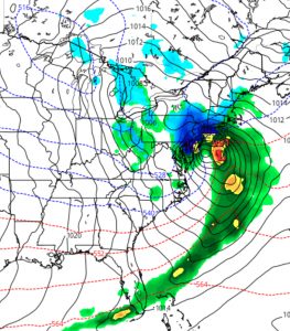
Last night’s models showed significant agreement that a classic coastal snow storm (“Miller type B”) will develop Tuesday night into Wednesday and intensify as it moves up the coast. Current QPF values are very high- as much as 1.80 to 2.00 inches water. This has the potential of translating into 14-20 inches of snow assuming a ratio of 1:10.
Current track is a ‘sweet spot’ for snow development in PHL and westward. Highest amounts on either side of the I-95 corridor.

Right now, current thermal profiles support snow, not a mix.
I’ll update later this morning with the latest models.

Our power is not scheduled to come back on Wednesday. What time is the storm expected to hit NW philadelphia/lower montco?
Snow is expected to start sometime during the evening on Tuesday, although the start time varies from model to model. There may be 2-3 inches by daybreak on Wednesday. The heaviest snow isn’t expected until Wednesday afternoon, but it will be snowing all day on Wednesday. This storm is not a good thing, even worse with the tremendous number of people still without power from last Friday.