
#Philadelphia #weather #PAwx #PhillyWx
Thursday Evening Update
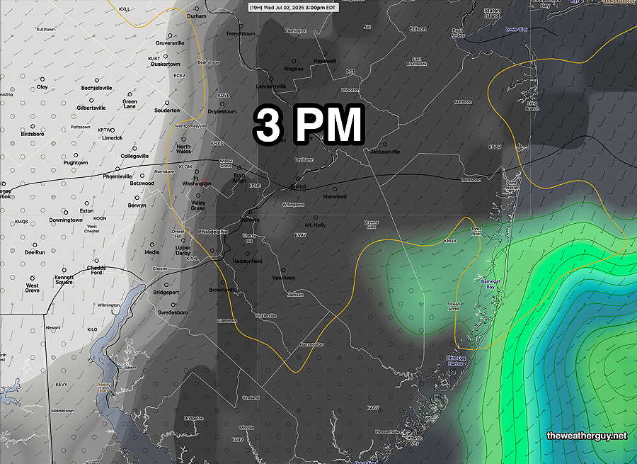
Posted Thursday 07/03/25 @ 6:11 PM — As forecast this morning, much of the energy and moisture for thundershower formation is north of our area.
Here’s what it looks like at 6 PM—
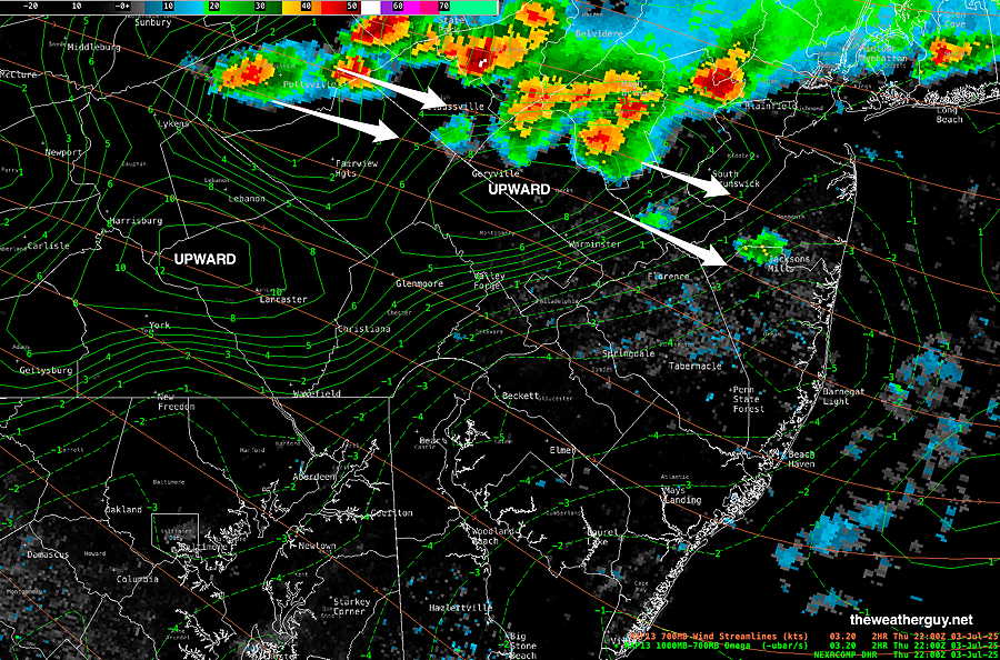
The latest REFS still shows some showers here around 8 PM, but it might be over-forecast.
The Fourth of July Weekend is looking quite nice, sunny but increasingly warm. Near 90º on Saturday, low 90s and more humid on Sunday.
Thursday & Fourth of July Extended Weekend
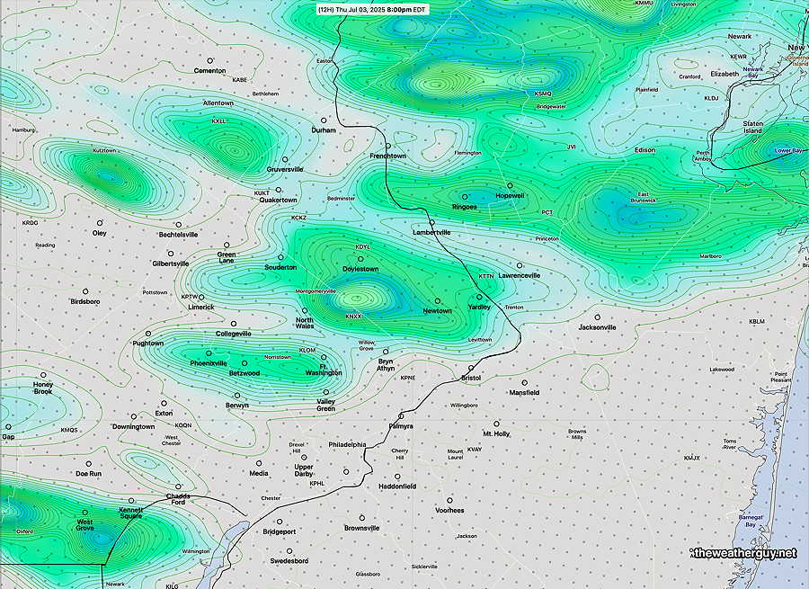
Posted Thursday 07/03/25 @ 9:38 AM — A front will move across the area with an upper level trough Thursday evening. Most of the energy and moisture will move to our north. Compared to recent thunderstorms, precipitable (cloud water) will be in the 1.4″ range compared to 2.1″ in recent storms, so rainfall amounts will be lighter.
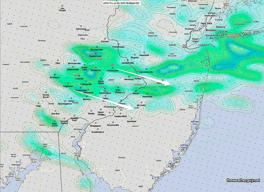
With the exception of New Jersey, which may see some isolated storms this afternoon, the area of showers and storms moves through the immediate Philadelphia area between 7PM and 11 PM, with the latest REFS leaning towards 9-10 PM —
The Fourth of July Weekend is looking quite nice, sunny but increasingly warm, especially by Sunday.
Due to the highly unbalanced political environment on X, I’ve considerably cut back auto-posting there. To receive all forecast postings, I suggest following me on mastodon.social or bluesky.social
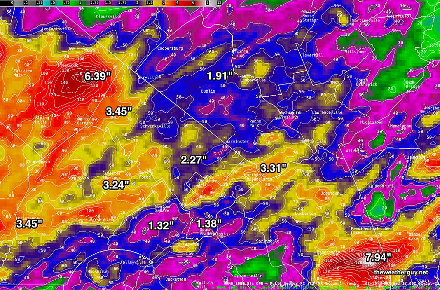
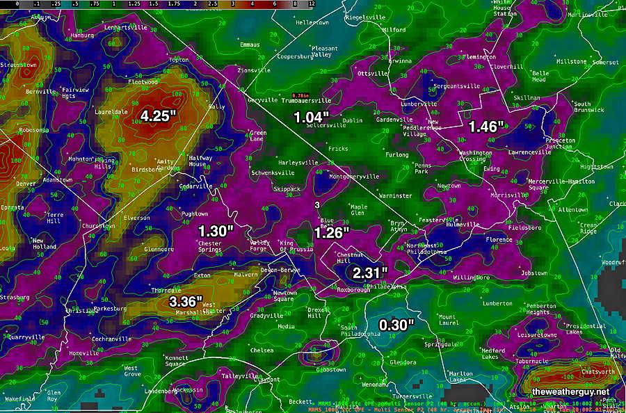
Here’s the latest MRMS rainfall estimate over the past 72 hours. (It’s still raining in eastern NJ, so these numbers aren’t final.
What difference does a year make? Last year at this time, we were ascending on the solar cycle curve, something well-studied and associated with decreased rainfall.
This year, we’re descending on the same cycle curve, having peaked a few months ago. We’ve just passed the solar maximum of this cycle. This climate change is especially prominent over periods of two solar cycles– the double cycle is called the Hale Cycle (The Hale Cycle refers to the magnetic polarity of sunspots that reverse every two solar cycles). Is this Hale Cycle the reason for last season’s drought and our recent rainfall pattern change? Maybe.
Wednesday Update
Posted Wednesday 07/02/25 @ 9:51 AM — The models still show lingering rain in eastern NJ while clouds are expected to thin and break for some sun from west to east about 12 -3 PM
Wednesday Forecast
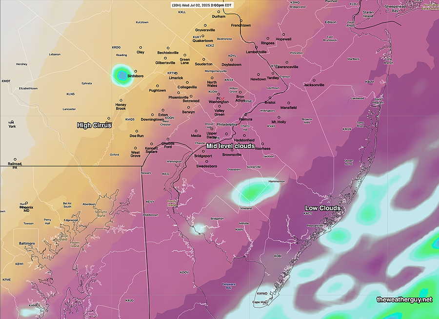
Posted Tuesday 07/01/25 @ 7:37 PM — The cold front hangs up along the coast as weak waves of low pressure move up along it. Expect additional light showers this evening and overnight into Wednesday morning. The sun will break through clouds from west to east on Wednesday afternoon.
Here’s the REFS cloud level forecast at 2 PM Wednesday—
Tuesday Forecast
Posted Tuesday 07/01/25 @ 7:49 AM — Multiple rounds of showers and thunderstorms gave our region significant rainfall in some areas—
A cold front moving through today. Some differences in the timing of the frontal passage with the HRDPS having the front move through about 4-5 PM, while the GFS has the front moving through about 8 PM with the showers and thunderstorms moving in 4:30PM to 7 PM
Similarly, the HRDPS has some showers moving through as early as 1 PM, especially just east of the city. The main line of showers and thunderstorms move through 3 PM -6 PM.
Based on yesterday’s model performance, I’m leaning towards the REFS and HRDPS which has showers and thunderstorms beginning at 3:00 PM to 4:30 PM, with some scattered activity possible as early as 1-2 PM mainly east of the city.
All models have rain and thunderstorms continuing through the evening and night as low pressure develops along the front. Some rain may continue into early Wednesday morning. Heavy rain is expected.
Some thunderstorms may be strong to severe, but current forecasts of helicity and vertical wind shear are in the low- moderate range only.
Tuesday Forecast
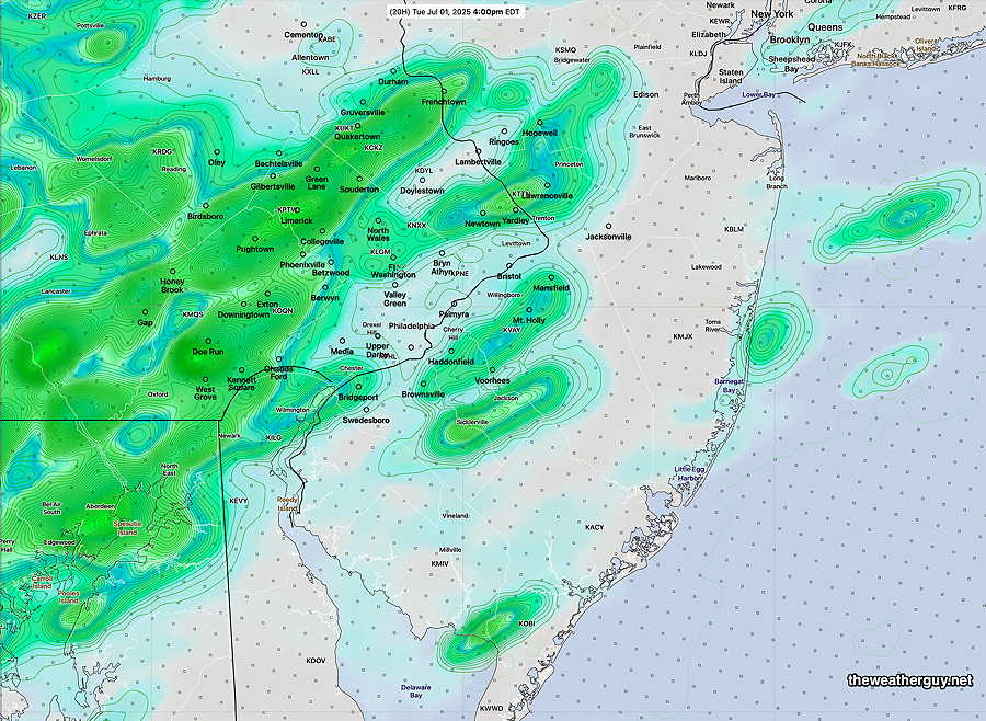
Posted Monday 06/30/25 @ 5:41 PM — Showers and thunderstorms moved in from the south between 2:30 PM and 4 PM.
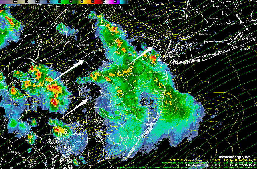
Very few of this morning’s models accurately predicted the timing and location of this afternoon’s storms. I always like to look back and see if any specific model did well. The HRRR, our best high resolution model, didn’t perform too well today, nor did the NAM-NEST. (The AI models don’t have the high resolution needed for thunderstorms.)
Looking back, the Canadian high resolution model (HRDPS) did reasonably well. The experimental REFS also did surprisingly well.
So with that, the REFS becomes “the model of the week”. It is currently forecasting showers/thunderstorms to return between 3 and 5 PM Tuesday afternoon. Some may be strong to severe. Stay tuned.
Monday Forecast Update
Posted Monday 06/30/25 @ 9:07 AM — Yesterday’s Model Blend (NBM) proved to be correct about the lack of showers this morning, and I’ll stay with the NBM for today’s forecast, with individual models showing a range of forecast times for showers and thunderstorms.
Pop up storms can occur anytime after 1 PM today with peak activity between 5 PM and 8 PM.
The latest NBM shows activity near the city picking up about about 1-2 PM just east of the city.
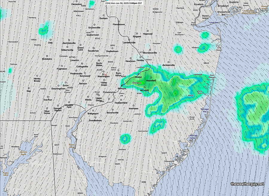
A considerable increase in coverage will occur later in the afternoon. Some areas may receive heavy rain in a short period of time.
Likely focus of heavier storms will be central areas of South Jersey in the mid afternoon and areas north of the city in the late afternoon.
Originally Posted Sun 8:50 PM —The ‘cold’ front that moved through Saturday has stalled just to our south and thunderstorms have been breaking out in South Jersey for much of Sunday, especially near the Delaware Bay and Cape May.
The front will return as a warm front on Monday. Large differences in the forecast exist for Monday morning. The AI version of the ECMWF and the latest GFS have scattered showers breaking out early Monday morning, while the regular ECMWF, the AI version of the Canadian GDPS keeps us dry until 2-4 PM.
The experimental RRFS has scattered pop-up storms in the morning; this may be an example of its tendency to over-forecast convective rain.
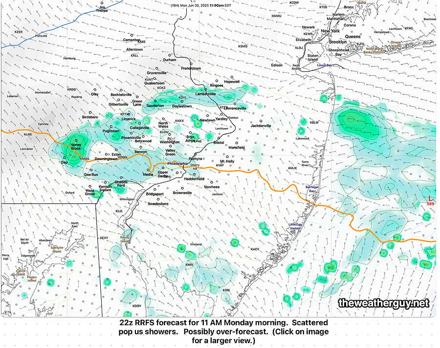
The ECMWF-AI has so much precipitation and clouds in the morning that it keeps our high temperatures in the mid to upper 80s instead of the low 90s forecast by the drier forecasts.
The model blend (NBM) keeps us dry Monday morning as well, and I’m leaning towards its forecast. Its high temp in Philadelphia is 90.5º
It’s a tough call.
The models all come together by Monday afternoon with showers and thunderstorms popping up anytime between 1 PM and 4 PM and continuing into the evening. Peak time is about 6 PM according to the NBM.
Tuesday looks even more interesting, as a cold front moves into very moist and unstable air over the Philadelphia region. Stay tuned.