Update 03/23/25 @ 8:42 AM — Sunny skies this morning will begin to very slowly fade as high cirrus clouds move in about noon. It likely won’t be truly ‘cloudy’ until after 5 PM.
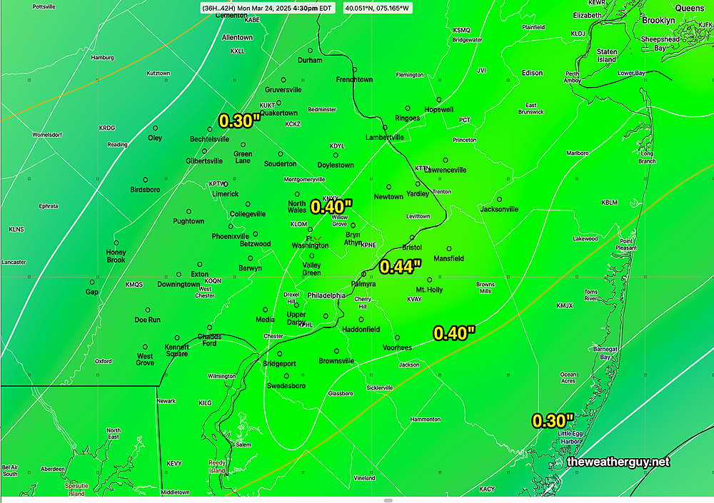
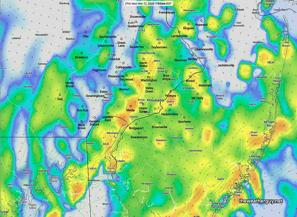
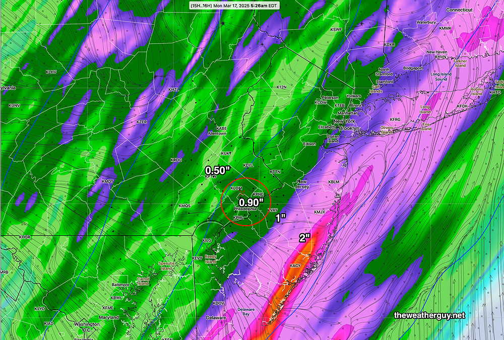
Rain moves in before daybreak Monday and continues through about 4 PM, with some widely scattered showers afterwards. Total rainfall ranges from 0.32″ to 0.70″ in the models. Here’s the ECMWF-AI-Single total rainfall forecast—
06z ECMWF-AI Single Total rainfall for Monday Contours are 0.1″ (Click on image for a larger view.)
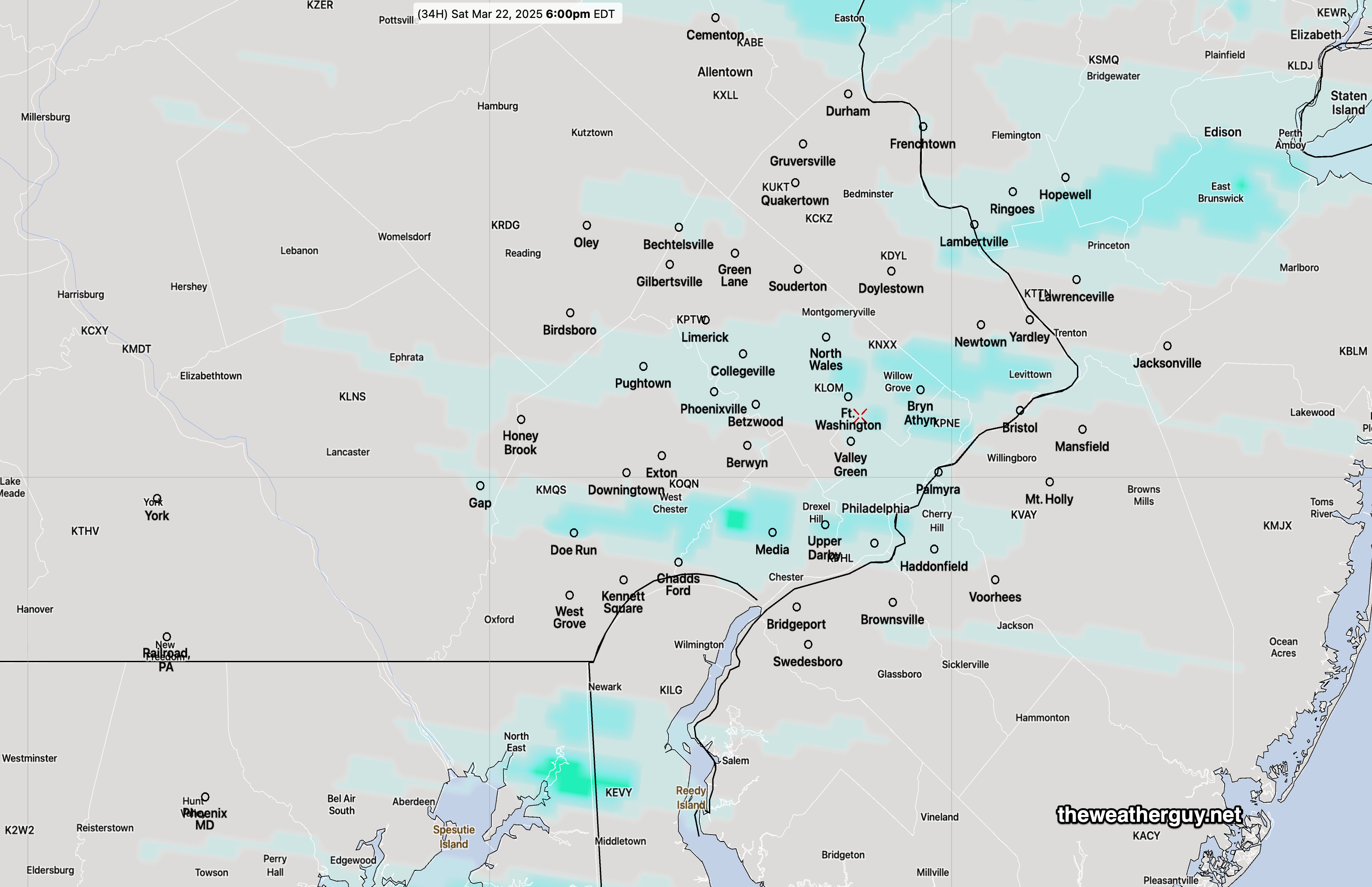
Update Sat 3/22 7:38 AM — The higher resolution models have any light showers moving through between 4:30 PM and 7 PM this evening. The lower resolution models keep any showers to our north. That includes the AI models.
Originally Posted Fri 5:01 PM —A reinforcing cold front will pass through about 2-5 PM Saturday afternoon. There will be a chance of light, scattered sprinkles/showers during the mid to later afternoon after the cold front passage.
NBM forecast hourly precipitation at 6 PM Saturday (Click on image for a larger view.)
Another approaching system for Monday will bring some cloudiness late Sunday with rain likely Monday.
Saturday Forecast
Cloudy early, then a varying degree of cloudiness with some sun through much of the afternoon. The front comes through mid to late afternoon with light sprinkles/showers. Increasingly windy and gusty in the afternoon. Temperatures drop below freezing Saturday night into Sunday morning.
NBM high temperatures: Blue Bell, PA 60º Philadelphia, PA 62º Above average uncertainty (based on standard deviation): ±2.2º
Sunday Forecast
Sunny and cold in the morning, then sunshine through slowly thickening high clouds in the afternoon. Windy in the morning, diminishing during the afternoon.
NBM high temperatures: Blue Bell, PA 49º Philadelphia, PA 51º Low Uncertainty (based on standard deviation): ± 1.7º
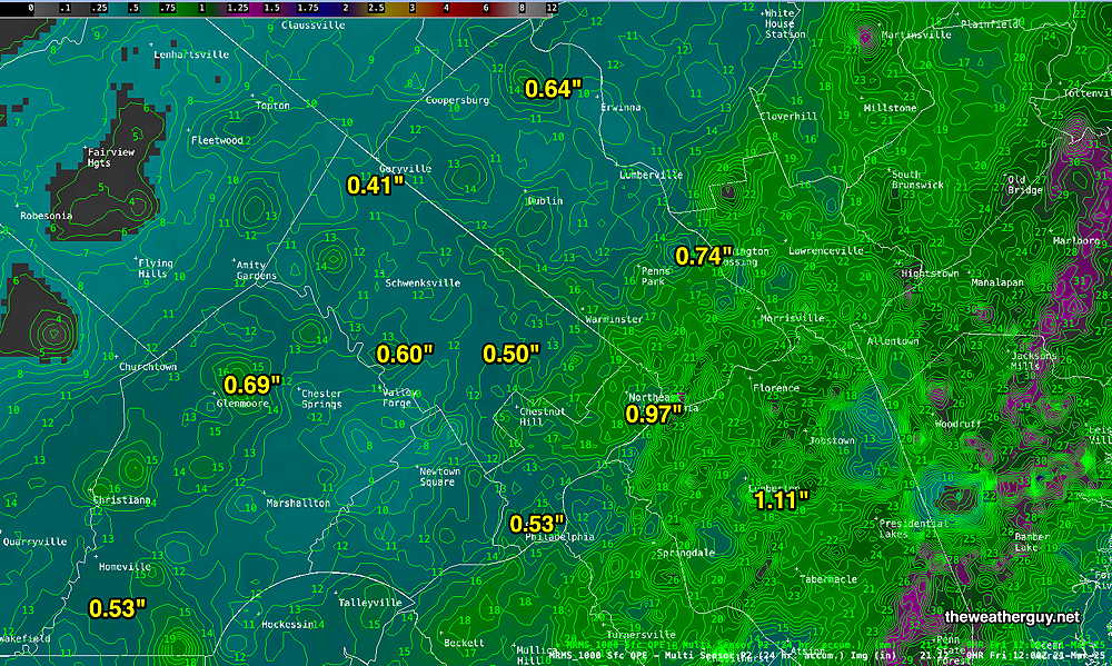
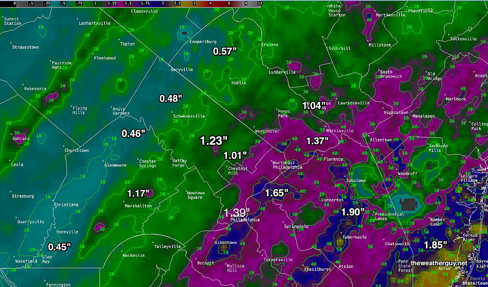
Fri 9:24 AM —Forecast Review — Last evening’s rain arrived within the time range given, but really about an hour or so later than I had expected. Total rainfall was somewhat on target, with much heavier rain than forecast eastern areas and in New Jersey.
Here’s the MRMS QPE (quantity of precipitation estimate)
MRMS rain-gauge measured rainfall combined with rain-gauge calibrated and interpolated radar-based summary of ACTUAL RAINFALL RECEIVED. Color shading is in inches. Line contour numbers are in mm. (25.4 mm= 1 inch) (Click on image for a larger view.)
Thursday Forecast Update
Posted Thursday 03/20/25 @ 11:04 AM — It looks like the breaks of sun will be in the morning. Increasingly cloudy in the afternoon.
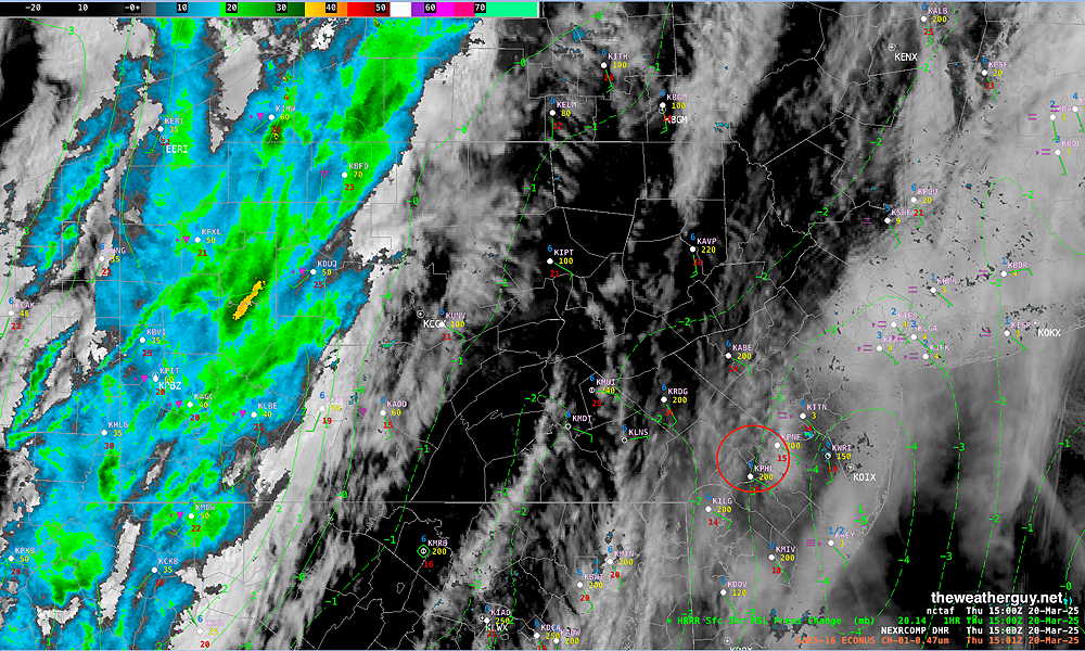
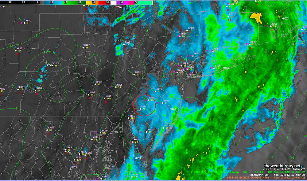
Visible Satellite and Radar with HRRR 3 hour surface pressure delta. Notice the area of negative pressure delta just east of Philadelphia. Low pressure will form in this area. (Click on image for a larger view.)
Posted Thursday 03/20/25 @ 8:42 AM —Today’s forecast mostly on-track. Low clouds this morning will give way to mid level cloudiness this afternoon. Some areas may see some sun for a period this afternoon, but most will remain cloudy. Showers and rain moves in from the west between 5:30 PM and 8 PM. Total rainfall this evening between 0.45″ and 0.70″ (western suburbs may receive the higher amount). Windy conditions later this afternoon and then again later tonight. The actual frontal passage may not have much in the way of winds.
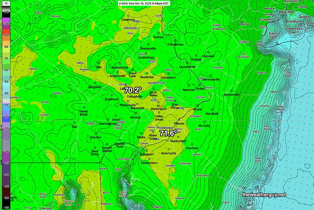
Posted Wednesday 03/19/25 @ 5:57 PM — The AI ‘experiment’ showed no winners, with the spatial and temporal resolution differences between the models over-shadowing any small differences in forecast high temperatures. That said, except for Center City, the NBM high temps were overall too low. Here’s the RTMA temps at 3:45 PM. the likely high temps for the day—
RTMA temperatures at 3:45 PM The RTMA records preliminary observed and interpolated temperatures at 15 minute intervals. (Click on image for a larger view.)
As for Thursday, a cold front (technically an ‘anafront’ type cold front, due to the rain following the frontal passage) will move across about 6 PM with showers and possible thunderstorms.
GFS forecast showing the ‘anafront’ type cold front. (Click on image for a larger view.)
Low clouds in the morning with mid-level cloudiness in the afternoon. Some breaks in the overcast possible just before the front moves across about 6 PM. Low pressure expected to form along the anafront, bringing more windy conditions. About 0.4-0.6″ of rain expected during the evening Thursday.
Yet Another AI Model ‘Experiment’
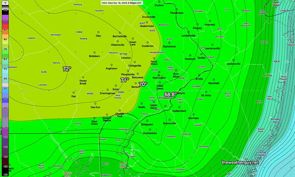
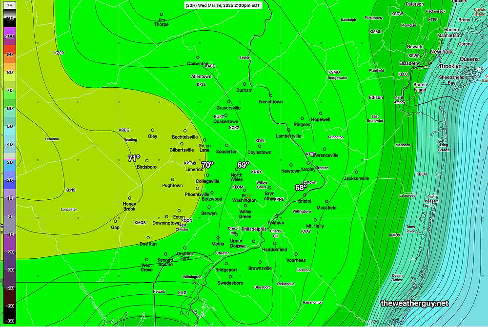
Posted Wednesday 03/19/25 @ 9:34 AM — There are differences today between the high resolution NBM model (our best model for temperatures) and the lower resolution ECMWF-AI-Single model regarding high temperatures for today.
The AI model has an easterly wind keeping temperatures from the city eastward below 70º, while large areas just west of the city are above 70º
ECMWF-AI-Single high temperatures at 2 PM. It should be noted that the AI model only forecasts on 6 hour increments, The high temperature will likely be reached at 3:00 PM or so, not 2 PM, so these temperatures may be a bit low. (Click on image for a larger view.)
Here’s the latest 12z NBM model high temperature forecast for today—
The latest NBM shows most of the area just under 70º as a high. (Click on image for a larger view.)
An interesting and significant difference in the forecast. Either way, a very nice day, with some high thing cirrus clouds moving in about 3 PM.
Thursday will likely have rain moving in between 3PM and 6 PM ahead of a cold front. Some ‘interesting’ weather possible.
Wednesday through Thursday Outlook
Posted Tuesday 03/18/25 @ 5:34 PM — Wednesday promises to be a spectacular day, with mild temperatures just short of 70º. Sunshine in the afternoon will be through some thin cirrus clouds as moisture and milder air move in aloft ahead of a cold front expected late Thursday.
ECMWF-AI Single forecast high temperatures at 2 PM. Lately, this AI model has been more accurate than the NBM regarding high temperatures. (Click on image for a larger view.)
A strong cold front approaches on Thursday with some rain/showers moving in by mid to late afternoon—
ECMWF-AI-Single forecast for 8 PM Thursday. Advancing cold front with low pressure forming on the front. Much convective activity (yellow green color) (Click on image for a larger view.)
About 0.5″ of rain is expected with this system.
Originally Posted Mon 8:04 AM —Some rain is still falling at the Jersey Shore and there’s a chance of a light shower this morning, especially east into NJ.
RADAR 8 AM Monday morning. (Click on image for a larger view.)
Clouds should break for some sun around noon or early afternoon.
The rain occurred later than forecast, the strong wind gusts preceded the rain. Many areas did eventually receive the 1+ inch forecast —
MRMS (Pass 2) rain-gauge measured rainfall combined with rain-gauge calibrated and interpolated radar-based summary of ACTUAL RAINFALL RECEIVED. Color shading is in inches. Line contour numbers are in mm. (25.4 mm= 1 inch) (Click on image for a larger view.)
Our next chance for rain is late Thursday into Thursday night with a system somewhat similar to Sunday’s cold front passage.
Posted Sunday 03/16/25 @ 7:51 PM — Based on the latest HRRR, the showers and storms arrive in the immediate Philadelphia area between 11:30 PM and 1 AM. The HRRR shows the rain area to “blossom” as the two separate lines merge.
22z HRRR forecast simulated radar at 1 AM (Click on image for a larger view.)
Sun 5:14 PM —Forecast Review — I’m disappointed with the forecast. And we need the rain.
So far, not much has played out as forecast yesterday and this morning. Two bands of precipitation have formed, as forecast, but the first prefrontal band has not had the heavy rain/thunderstorms as forecast.
Here are the two bands at 5 PM—
The prefrontal band of rain is nothing as forecast yesterday, with the main axis just east of the Delaware River. The main band, west of State College, may not provide the heavy rain here that was forecast. The above shows 3 hour pressure changes (green contours) that doesn’t suggest a very strong deepening low pressure to our south. It’s still possible that some heavier rain occur east of the 95 corridor. (Click on image for a larger view.)
This afternoon’s 18z HRRR is still forecasting heavy rain from the city eastward. I guess we’ll see.
Today’s 18z HRRR rain forecast from 2 PM onward. (Click on image for a larger view.)
The ECMWF-AI model forecast still has heavy rain of over 1″, but the rain occurs later tonight into Monday due to a second low pressure system forecast to develop.
Sunday Forecast Update
Posted Sunday 03/16/25 @ 11:09 AM — Here are the trends I’m seeing with the approaching storm system and cold front—
The approaching system has slowed. Rain and thunderstorms are now forecast to enter the western Chester/Montco/Bucks counties between 2 and 4 PM.
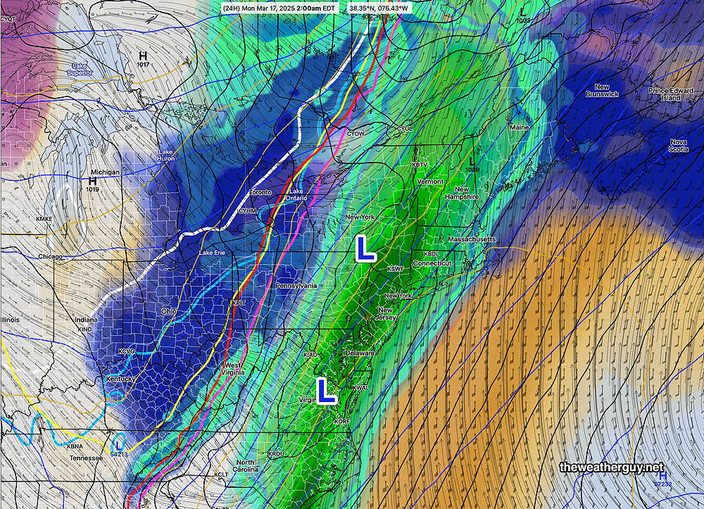
Multiple Low pressure systems will form along this approaching front. Based on the several runs of the ECMWF-AI-Single, rain and showers will extend into Monday morning and possibly longer at the shore.
This morning’s HRRR shows a significant increase in CAPE, the thermal energy ingredient that was missing from the model forecasts yesterday. With CAPE increasing to be over 300 joules/kg in western suburbs, the risk of stronger thunderstorms is increased. (CAPE at 300 is still low by mid-summer storm standards, but enough to put more severe weather into play.)
Here’s the latest ECMWF-AI-Single forecast for 2 AM—
ECMWF-AI_Single forecast for 2 AM. Additional low pressure systems form along the front, extending rainfall duration. (Click on image for a larger view.)
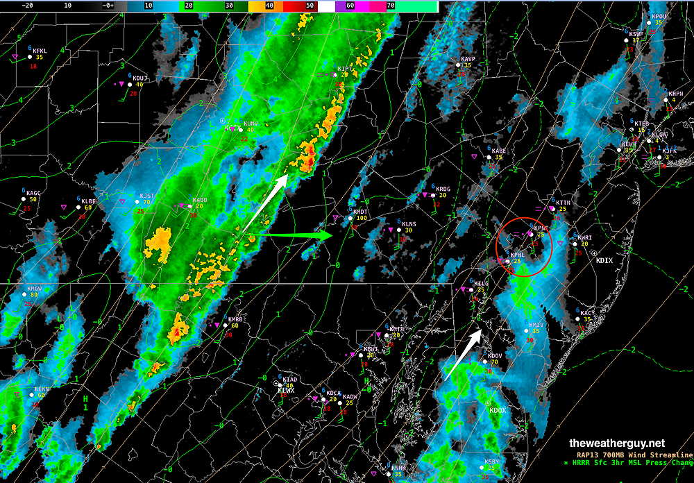
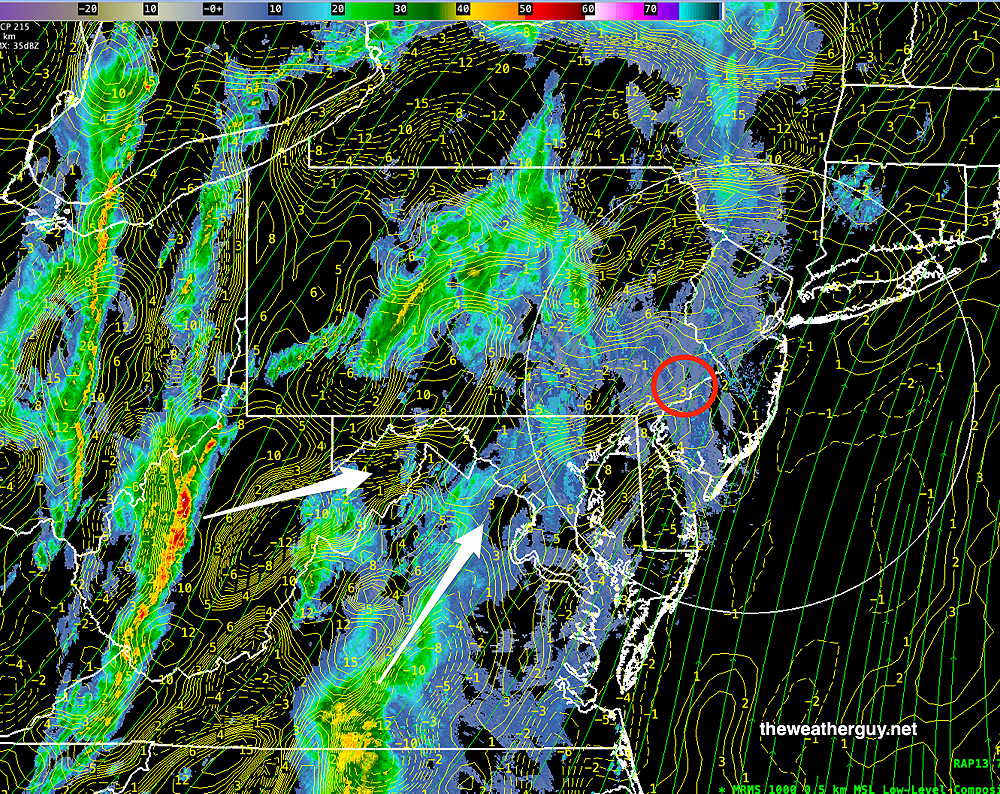
Here’s the current MRMS radar. Areas of storms and upward vertical motion to our southwest and west will approach our area—
Current MRMS radar combined with NEXRAD Image and RAP model Omega (yellow contours = vertical motion) with 700 mb wind streams. The main precipitation areas will arrive mid afternoon in western suburbs. (Click on image for a larger view.)
Sunday Forecast Update
Posted Saturday 03/15/25 @ 5:34 PM — As expected, some elements of the earlier model’s forecast have changed. Here’s the current thinking, based on the latest HRRR and ECMWF-AI-Single models—
Some light showers, mostly far western suburbs possible in the late morning Sunday.
Wind gusts increase to near 40 mph around noon.
Showers and thunderstorms develop between 12 PM and 2 PM just west of Philadelphia.
Rain becomes increasingly heavy by 4 PM -5 PM from the city westward.
Wind gusts near 50 mph around 4 PM -5 PM in the city.
Showers and storms continue into the evening beyond midnight.
Heavy activity at the Jersey shore about 11 PM – 2 AM
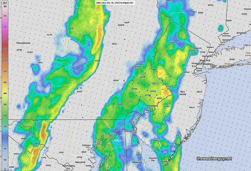
The high resolution HRRR shows the rain approaching as two lines/areas—
HRRR simulated radar forecast at 5 PM (Click on image for a larger view.)
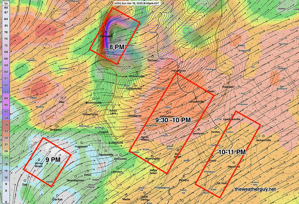
Many areas will see the possibility of damaging high winds and heavy rainfall. Here’s a simulated radar sequence with helicity, as forecast by the HRRR—
18z HRRR simulated radar in approximately two hour increments from 5 PM through 1 AM. Brown-red contours are helicity contours. Some areas have helicity values as high as 850 m2/s2. (Click on image for a larger view.)
As mentioned earlier, high helicity values with high wind shear can create tornadoes, although thermal energy in the form of CAPE is absent tomorrow. Areas to our west and to our north may see the most severe weather, although even the Jersey shore may see some severe weather.
Saturday Update and Sunday’s Potential Severe Weather
Posted Saturday 03/15/25 @ 9:18 AM — The fog, low clouds and drizzle are here and we’ll be locked in to this for much of the day. The models that had some clearing later this afternoon was based on their forecast for a warm front to move north of our area.
There are still models that show this, but the latest AI model (ECMWF-AI-Single) keeps the warm front to our south and the cloudiness persistent.
(This is the reason yesterday’s AI model had only forecast a high today of 52º, in contrast to the NBM which was forecasting a highs in the low 60s.)
Turning to Sunday…
The potential for severe weather on Sunday has been well-advertised. The latest HRRR supports the likelihood of severe weather, including tornadic activity. The most likely timing is between 5 PM and 11 PM Sunday evening. Wind gusts 50-60 mph area forecast.
In reviewing the 06z HRRR, two potential severe parameters stuck out—
06 z HRRR forecast for 8 PM Sunday. AREA OF EXTREME HELICITY near Allentown at 8 PM Subsequent very high helicity in the red areas shown at the later times shown. (Click on image for a larger view.)
The area near Allentown is showing extreme helicity values in the 1150 m2/s2 range. In our area, helicity greater than 1000 often results in some tornadic activity. A missing ingredient is high CAPE (thermal instability energy), but the high wind shear and extreme helicity values can compensate for that missing thermal energy source.
This forecast is 40+ hours in the future. Expect the areas highlighted above to change over the next 30 hours.
Saturday Forecast Update
Posted Friday 03/14/25 @ 9:29 PM — With Daylight Saving Time in effect, the models are available an hour later. My usual posting time for the Weekend Weather Forecast, between 5 PM and 6 PM, missed several models.
There are some changes in the forecast that have come to light with the these afternoon models. In addition to low clouds for Saturday morning, it appears that fog and even some light drizzle may develop early Saturday morning, according to the several models. This will be especially true along the Jersey Shore. Fog dissipates towards noon. We may see some brightening of the skies in the afternoon on Saturday.
Here’s tonight’s 00z NBM showing visibility less than 1/2 mile for much of the region at 10 AM—
00z NBM visibility Saturday 10 AM. Most areas less than 1/2 mile visibility. (Click on image for a larger view.)
Previously Posted Fri @ 4:10 PM — —Deep low pressure will move up through the Great Lakes this weekend as additional lows develop along and ahead of a cold front.
Today’s 12z GFS forecast for 2 PM Sunday. Rain just moving in with increasing winds. (Click on image for a larger view.)
Clouds ahead of this system will be with us on Saturday.
Some showers are possible as early as late Sunday morning, especially west of the city. Strong winds, wind shear and high gusts may result in downed trees. Rainfall will be heavy with the heaviest occurring during Sunday evening into the after midnight hours. Rainfall about 1.1″
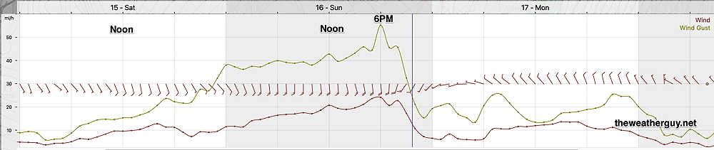
GFS winds and wind gust for KLOM Blue Bell, PA. . High winds Sunday. (Click on image for a larger view.)
A brief dip in the jet will allow cold air Monday into early Tuesday. Temperatures rebound quickly though next week.
Saturday Forecast
Low clouds for much of the day. Mild. There may be some breaks in the cloudiness late afternoon into the evening.
NBM high temperatures: Blue Bell, PA 60º Philadelphia, PA 62º High Uncertainty (based on standard deviation): ± 4.2º AI model high temperatures are about 10 degrees lower ~52º!
Sunday Forecast
Cloudy with showers west of the city by late morning. Showers, thunderstorms and high wind gusts in the afternoon into the evening and past midnight. Wind gusts near 50 mph possible. Rainfall 1.1″
NBM high temperatures: Blue Bell, PA 67º Philadelphia, PA 68º Average uncertainty (based on standard deviation): ± 2.4º