Sun 5:22 PM —Forecast Review —There’s a lot more activity after 5 PM today than predicted by my ” RRFS forecast experiment” —
Radar at 5:20 PM From https://weathertap.com (Click on image for a larger view.)
We’ll see if the next main area of storms comes in between 8 and 10PM.
Watching the Phillies – Watching the Weather
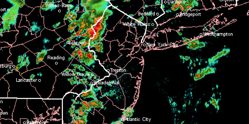
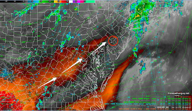
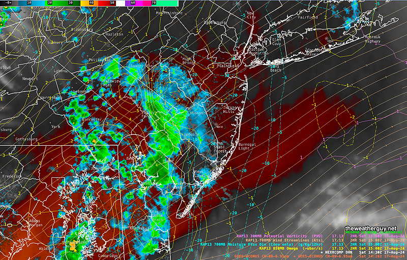
Posted Sun, 08/18/24 @ 3:13 PM— It’s the bottom of the 5th inning and the storms have formed in generally the same location as predicted by the RRFS experiment. Here’s the current radar—
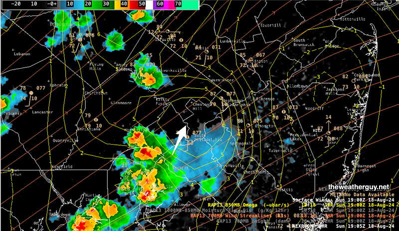
Current Composite Radar with RAP model 850 Omega (yellow contours) and 700 mb wind streams. Remarkably similar to the RRFS forecast. (Click on image for larger view.)
The storms are moving towards the stadium and should be there within the hour, although they may sideswipe that part of the city.
Forecast Experiment
Posted Sunday 08/18/24 @ 11:43 AM — I’m going to do a forecast experiment based exclusively on the experimental RRFS.
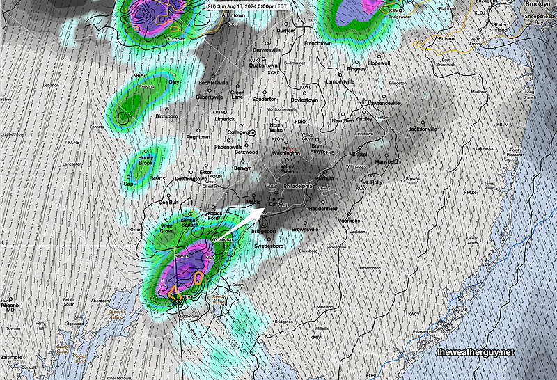
This morning’s 12z experimental RRFS just became available (forecast through 19 hours). It has little activity until 3:30-5 PM. Then storms develop and move in from the southwest in just a few spots—
RRFS 5 PM 1 hour accumulated forecast (Click on image for a larger view.)
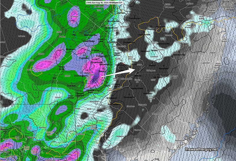
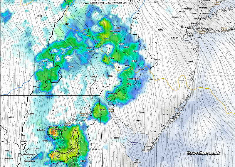
By 8-10 PM the main area of storms move in from the west—
12z RRFS forecast for 10 PM 1 hour accumulated rain (Click on image for a larger view.)
Interesting Weather Day – Sunday
Posted Sunday 08/18/24 @ 10:30 AM — An upper trough with increasing jet stream wind flow and a favorable position for jet streak lift (“right entrance region”) along with high CAPE values (>2000 joules/kg) and moderately high PWAT (1.8″ water) will create conditions for showers and thunderstorms this afternoon with heavy rainfall.
While a scattered shower and thunderstorm is possible late morning and early afternoon, things begin to get going between 3 and 6 PM. Many of these storms will develop in-place instead of the usual line of moving storms. Low shear values and low helicity suggests severe storms or tornadoes notlikely, although still a low possibility extreme South Jersey and Delmarva area.
It’s unclear how this might affect today’s afternoon Phillies game; they may be able to finish the game with current timing of things.
The more sun we get before 3 PM, the more intense the thunderstorms will be.
Here’s the current setup—
Current conditions Sunday morning. Water Vapor with RAP model 700 mb windstreams and 700 heights. Superimposed composite Radar. (Click on image for a larger view.)
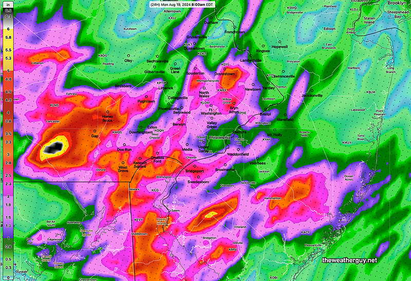
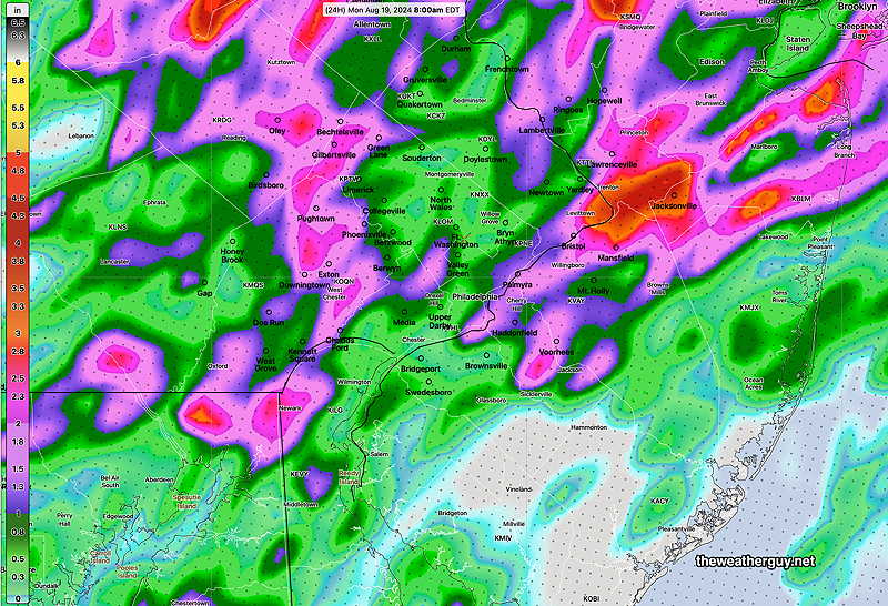
Total Rainfall predicted by 8 AM Monday —
12z NAM-NEST(Click on image for a larger view.)12z, HRRR (Click on image for a larger view.)06z experimental RRFS (Click on image for a larger view.)
Which of the above are correct? None of them. Model predicted heavy rainfall is simply a guide of what rainfall potential is in an area.
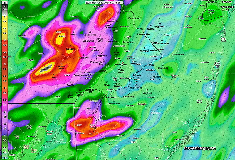
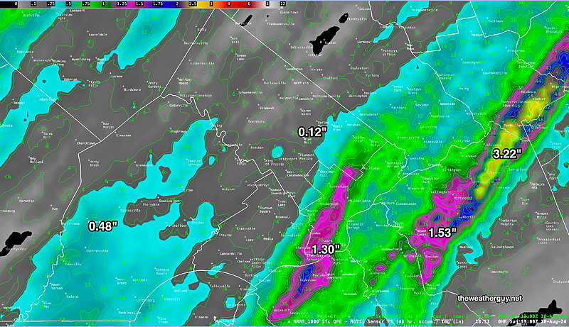
Here’s the rainfall totals estimate we’ve received so far this weekend—
MRMS rain-gauge measured rainfall combined with rain-gauge calibrated and interpolated radar-based summary of ACTUAL RAINFALL RECEIVED. Color shading is in inches. Line contour numbers are in mm. (25.4 mm= 1 inch) (Click on image for a larger view.)
I’ll be keeping an eye on things for any changes. Stay tuned.
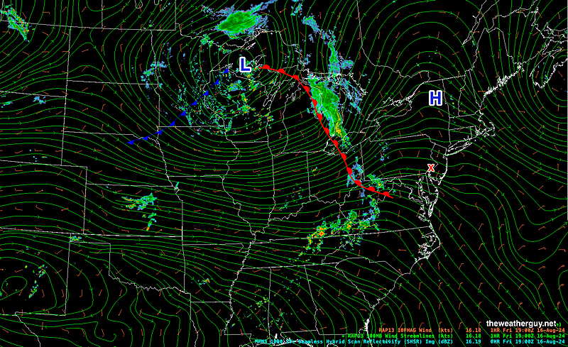
Posted Saturday 08/17/24 @ 10:36 AM — Those inconsistent model forecasts I spoke of yesterday are coming home to roost. The showers have moved in mid morning, per my original forecast, before I updated it last night to a later onset of the showers. Here’s the current radar/water vapor—
Water Vapor/Composite Radar with superimposed RAP model vertical velocity pressure (Omega- yellow contours) and horizontal moisture convergence (blue contours) and 700 mb wind streamlines. These showers are moving up from the southwest. (Click on image for a larger view.)
Yesterday’s 12z models (at least some of them) accurately captured this, but later model runs did not. Of interest is the experimental 12z RRFS model which was superb with the forecast, but like the other models, it backed away with later model runs. Here’s yesterday’s 12z RRFS—
08-16-24 12z RRFS forecast was incredibly good with this forecast. (Click on image for a larger view.)
For weather nerds out there, I’ve been keeping a separate web page with changes and observations about the RRFS model. Just two days ago, they changed the physics package in the model for predicting precipitation.
It appears that additional showers are likely today, with some breaks in the action.
Update Fri 8/16 8:32 PM — A quick update. I’ve reviewed some additional models that have become available since posting this. Instead of mid morning, showers will move in between 11 AM and 2 PM Saturday. The Jersey shore may not see any rain during the daytime Saturday.
Originally Posted Fri 4:48 PM —While Ernesto is predicted to be about 600 miles east of the Jersey Shore this weekend, the presence of a tropical system often seems to create inconsistent model forecasts for areas seemingly unaffected directly by the storm.
Such is the case this weekend, with Saturday‘s forecast already having changed from yesterday.
An approaching warm front had not been expected to affect the immediate PHL area with showers until the evening. That’s no longer the case. Today’s models have an area of showers and possibly thundershowers well ahead of the warm front moving in during the morning hours Saturday.
Here’s the current (Friday) position of the warm front —
Friday afternoon RAP model 500 mb wind streams with superimposed MRMS radar. I’ve drawn the warm front. Showers ahead of this f ront will move in mid morning Saturday. (Click on image for a larger view.)
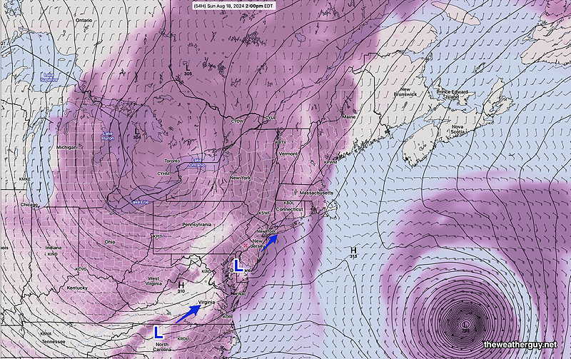
On Sunday, the low pressure system in the Great Lakes area will slowly move east, as weak disturbances develop and move over us from the south on Sunday.
GFS 700mb level (10,000 feet) forecast for Sunday 2 PM. Waves of low pressure will cause showers and thunderstorms to develop throughout the day Sunday into Sunday night. (Click on image for a larger view.)
Expect further changes in this weekend’s forecast. Check back for updates.
Saturday Forecast
Cloudy with showers, maybe a rumble of thunder mid morning. Then a mix of clouds, bright spots, even some sun, with scattered showers.
NBM high temperatures: Blue Bell 83º Philadelphia 84º Uncertainty (based on standard deviation): much higher than average ± 3.5º
Originally Posted Fri @ 4:48 PM — —
Sunday Forecast
Cloudy with showers and thundershowers/thunderstorms throughout the day. An occasional bright spot and even some sun can’t be ruled out. Chances of a heavy thunderstorm increases late in the afternoon and evening. Very humid with dew points in the 70s.
NBM high temperatures: Blue Bell 81º Philadelphia 83º Uncertainty (based on standard deviation): above average ± 2.5º