
#Philadelphia #weather #PAwx
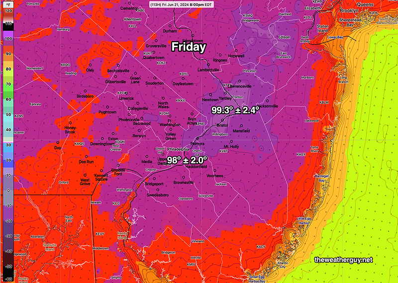
Friday through Sunday Update
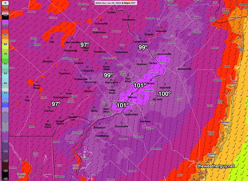
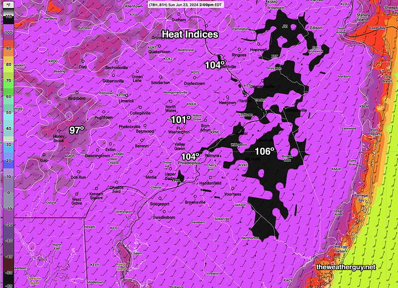
Posted Thursday 06/20/24 @ 9:28 AM — Last night’s models show a trend towards higher temperatures Friday through Sunday, with the ECMWF and NBM showing areas exceeding 100º on Sunday. (That’s actual temperatures, not heat indices.) Heat indices (“apparent temperatures”) may exceed 105º)
High Temperatures Sunday—
Apparent Temperatures (Heat indices) on Sunday—
So the current trend is for higher temperatures over the weekend than previously forecast earlier this week.
Thursday Friday Forecast Update
Posted Wednesday 06/19/24 @ 7:18 PM — The model guidance has backed off on the chance of showers in this area for Friday evening. Showers and thunderstorms will likely stay to our far north.
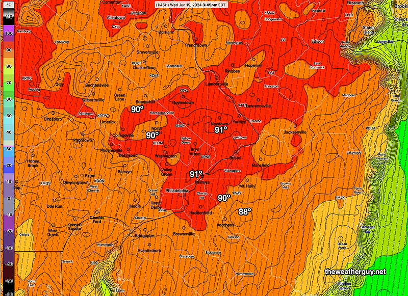
Today’s highs, based on the RTMA at 3:45 PM, showed temperatures in the city were close to those forecast yesterday by the NBM, although higher temperatures that had been forecast near Trenton did not materialize. Here’s today’s RTMA readings at 3:45 PM —
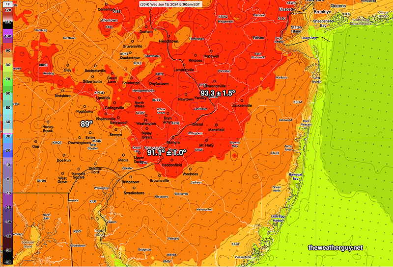
For Thursday, temperatures a degree or so warmer than today. Dew points will be higher, though, making it feel hotter.
The models have also come down a degree or so for Friday‘s high temperatures. Still forecast in the low to mid 90s.
Some pop-up thunderstorms possible Saturday. Some may be strong.
Temperatures above 90º now forecast through Monday. Perhaps a drop below 90º for Tuesday, then a return to the 90s!
Forecast Update
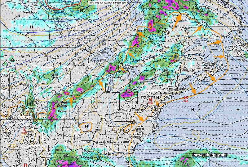
Posted Tuesday 06/18/24 @ 7:52 PM — This afternoon’s models are showing a mid level disturbance moving through over the top of the heat dome. Scattered showers and thunderstorms are possible Friday evening, especially areas north of Philadelphia.
Increasingly Hot
Posted Tuesday 06/18/24 @ 5:36 PM — Other than the increasing heat over the next several days, there isn’t much ‘weather’. No showers or thunderstorms are expected in this area into Friday, however, there’s a chance of scattered storms Friday evening/night, especially northwestern areas.
The temperatures we’re seeing are hot. What’s most concerning is that it isn’t yet officially summer.
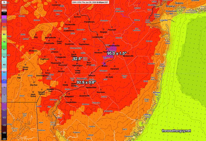
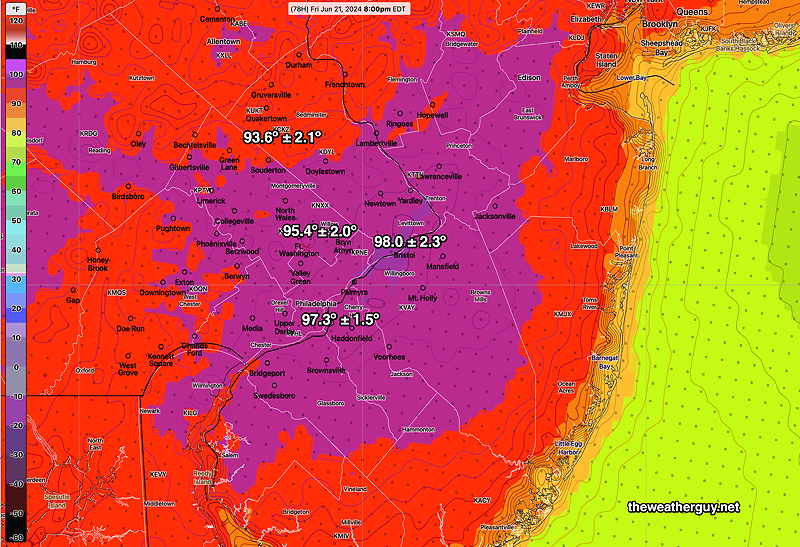
A picture, or in this case several pictures, capture the increasing temperatures Wednesday through Friday —
Saturday may be as hot as Friday and Sunday looks quite hot too.
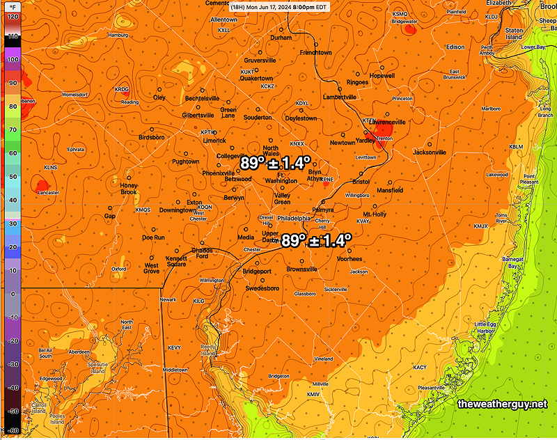
Posted Monday 06/17/24 @ 8:34 AM — Most models are keeping the high temperatures in most areas in the Delaware Valley just below 90º on Monday, but dew points are expected to reach the mid 60s in the afternoon. As a result, heat indices will be about 91º in many areas.
Here’s the latest NBM high temperature forecast for today, Monday —
Lower 90s are expected Tuesday and Wednesday. The heat gets more serious on Thursday with temperatures in many areas above 95º
By Friday, the heat is expected to be intense—
Previously Posted Sun 7:56 PM —I guess you’ve probably heard that it’s going to be hot this week. This northward advance of hot air has been well-advertised by the extended range models as early as 2 weeks ago. The ‘heat dome’ will be over much of the central and northeastern US (even well into Canada) through at least next Saturday or Sunday.
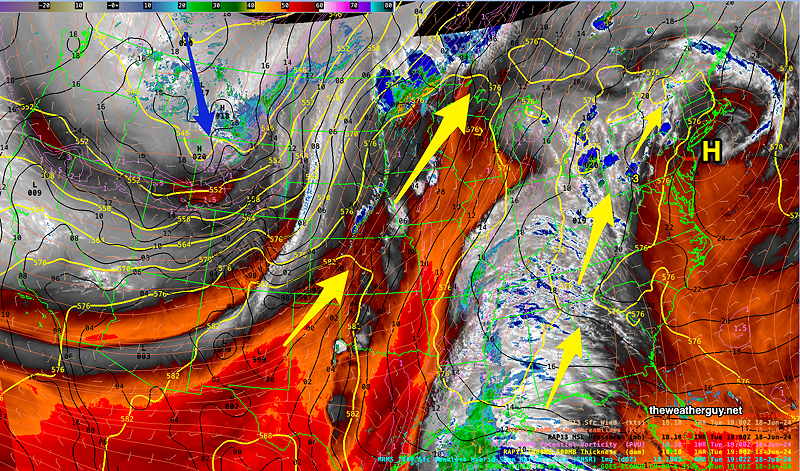
The heat dome can be ‘visualized’ through a calculated weather parameter called thickness, specifically the 500mb-1000mb thickness. This thickness parameter reflects the average temperature (density) of of the lower half of the atmosphere. Greater values of this parameter show greater average temperature.
In winter, the 540 thickness level often demarcates the rain-snow line.
In summer, the 576 thickness is useful to visualize the outline of the heat dome. I like to think of it the outline of a horizontal slice through the atmosphere that only includes its (hottest) thickest area. There’s nothing magical about 576, but I find it to be the number that seems to best define the outline of the heat dome. Strangely, there’s often showers/thunderstorms on the northern side of the 576 thickness line.
Here’s the ECMWF forecast for Wednesday. The orange line is the 576 thickness line, outlining what the news is calling a heat dome—
Here’s the this morning’s NBM forecast highs through Wednesday. Temperatures on Thursday through Saturday are expected to be even higher.
| MONDAY | TUESDAY | WEDNESDAY | |
| BLUE BELL | 89.0 | 92.3 | 92.8 |
| PHILADELPHIA | 89.7 | 93.1 | 93.6 |
The NBM is a mean (average) temperature calculated from 40 + models. In past summers, high temperatures were best calculated by adding the standard deviation (sd) to the mean, in this case adding about 1.5º.