THIS WEEK’S WEATHER

#Philadelphia #weather #PAwx

Friday Forecast Update

Posted Thursday 02/01/24 @ 8:35 PM — Thursday’s cloud forecast was again less than stellar.

As for Friday, the cold front is on scheduled to pass through about 3AM tonight with showers. About 0.25 inches of rain will fall with this frontal passage.

Following the cold front, cloudiness and even some widely scattered sprinkles will remain through Friday morning and it looks like considerable cloudiness will remain for much of the afternoon. This is due to an upper trough and an upper jet streak just to our west, resulting in vertical upward motion.

The weekend still looks to be sunny with high temps a few degrees above seasonal averages.

As for Groundhog day, what a crazy annual ritual! Forget about the groundhog’s forecasting technique…I don’t understand the the entire process—

• Does the groundhog have to see his shadow? How do we know he see’s his shadow?
• Or do we have to see that the groundhog see’s his shadow?
• Or do we have to see that the groundhog has a shadow?
• Groundhogs are so low to the ground. Don’t they always have a shadow?

Well, enough of that.


Thursday Update

Posted Thursday 02/01/24 @ 9:12 AM — One of the toughest forecasting challenges is predicting cloud cover and in the past two weeks, it’s been seemingly more difficult.

When I posted the forecast last night, I knew there were large differences in the forecast cloudiness between the models. I went with the ensemble forecasts (HREF) and the NBM.

Even though there is much more cloudiness right now than I had expected, and the HREF is showing the clouds now, it still forecasts the clouds to be moving out later this morning. I guess we’ll see.
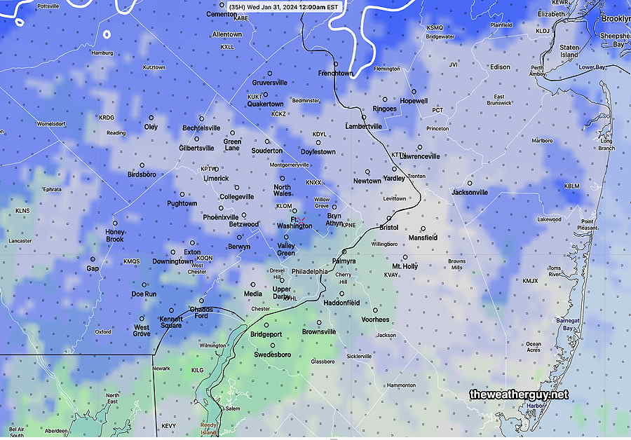
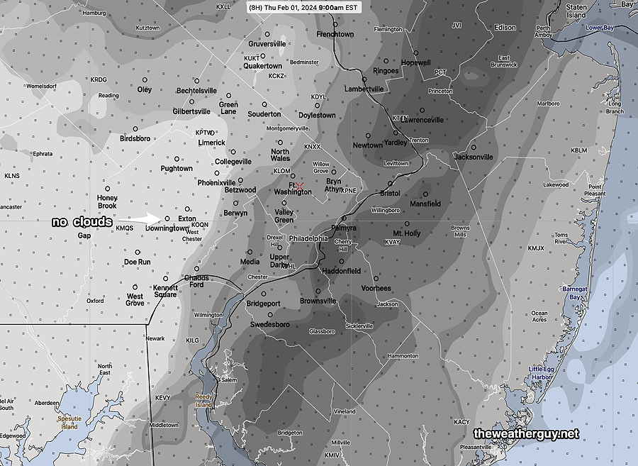
HREF clouds—

02-01-24 06z HREF forecast cloud cover in percentage. (darker = greater cloud cover) (Click on image for a larger view.)

Thursday Friday Update

Posted Wednesday 01/31/24 @ 7:44 PM —The clouds we had Wednesday will move out for Thursday morning and much of the afternoon. Thursday will be partly to mostly sunny and mild for February (48-50º) Clouds in advance of a cold front approaching from the north will move in during the late afternoon and showers associated with the front will move through about 3 AM Friday—

01-31-24 12z ECMWF forecast for 1 AM Friday morning. A cold front moving through our area about that time with showers. (Click on image for a larger view.)

Friday may dry out following the cold front, but the upper trough will move through and we’ll have plenty of clouds. (Maybe a few sprinkles). Highs in the mid 40s, still above seasonal averages.

Saturday looks sunny and near seasonable temps. (42-43º)
Sunday looks sunny and a bit milder.

Very mild weather has moved in the mid-section of the US. It’s not completely clear how much of that we’ll see, but the trend is for milder next week. No snow. Maybe even dry.


College of Cardinals

About one half hour before sunset, if I’m home, I like to treat the cardinals in my neck of the woods to safflower seed. Anticipating the ‘feast’, they line up in the trees, waiting for me to put clumps of seeds on the railings of our deck.

While not able to capture on camera the shear large number of birds that come out for the occasion, today I counted about 15 taking part.

I call it a meeting of the “College of Cardinals”. It’s interesting— the male cardinals take over first and then the females come by to eat afterwards.

“The College of Cardinals”
Northern Cardinals as seen from our window

THIS WEEK’S WEATHER

#Philadelphia #weather #PAwx

Wednesday

Posted Tuesday 01/30/24 @ 5:28 PM — Low pressure developing to our south will move off to the southeast. In the process, some colder air will move in for Wednesday in a narrow trough. We’ll have cloudiness on Wednesday for much of the day, the clouds breaking up towards evening.

By Thursday, high pressure and an upper air ridge to our west will move in and result in milder temperatures.

The ECMWF forecast for Wednesday afternoon captures the next two days—

ECMWF forecast for Wednesday at 4 PM. Coastal low moves off to the southeast . Milder air to our west is poised to move in for Thursday.
The Winter Outlook Page about potential future storms in the coming 10 days has been updated.
Tuesday -Wednesday

Posted Monday 01/29/24 @ 5:33 PM — The low pressure system expected to develop in West Virginia Tuesday evening is expected to move to our south.

Some models are forecasting some light snow showers and mixed light snow/light rain during the late Tuesday afternoon and evening into Tuesday night. There may be a dusting/coating in parts of Lehigh and Berks counties by Wednesday morning.

With temperatures expected to be above freezing, no accumulation is expected in our immediate area.

Here’s the NBM forecast for precipitation type at midnight—

01-29-24 18z NBM precipitation type. Blue- snow green=rain The lighter the shading, the less probable. The white contour at visible at the top is the 32º line. (Click on image for a larger view.)
updated my Winter Outlook Page about potential future storms in the coming 10 days.


Originally Posted Mon @ 9:49 AM — This week’s weather will be characterized by a very amplified upper ridge in the west and a persistent colder trough in the east that reloads with colder air by the weekend.

The main jet flow will keep any storms, both in the northern jet and southern jet, to our south. (The position of this trough is looking a lot like last year’s persistent eastern trough, in the ‘wrong’ position for snow in our area.)

The forecast image below for the NAEFS captures the setup, expected to persist through the weekend.

NAEFS statistical “mode” version model combined with GEFS “bias-corrected” precipitation model forecast for Wednesday. The cold air from eastern Canada will reload the positively tilted trough (dark blue line) over our area. Meanwhile storms developing around the bend in the jet (north Carolina) will move to our south and east, missing us. (Click on image for a larger view.)

Monday —Despite the some sunshine this morning (Monday), expect more cloudiness later this morning into this afternoon, but also with some breaks of sun possible at times. (an uncertain cloud forecast)

Energy dropping down (in central Canada) will cause a storm to form to our west Tuesday into early Wednesday, but light snow with this system should stay to our west and south—

Current satellite water vapor image Monday morning with superimposed RAP model 500-1000 mb thickness lines (yellow), Mean Sea Level Pressure isobars (black contours) potential vorticity (fine violet contours) with superimposed MRMS RADAR. Disturbance (1) will drop down and develop into weak low pressure at (x) the bend in the jet. It’s expected to move off to our south and east. (Click on image for a larger view.)

So an interesting jet flow.

Colder over the weekend. Chance of possible snow next Monday.