
#Philadelphia #weather #PAwx
Weekend Storm Update -Late Thursday Edition
Posted Thursday 01/04 @ 10:08 PM — A quick update. Some of the large changes in this afternoon’s 18z model runs have reverted back to previous forecasts. In fact, tonight’s 00z HRRR backed off on some of the snow with more rain. The NAM just available is similar again to other models and has the precip ending Sunday morning.
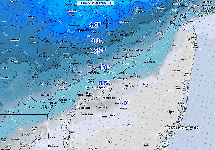
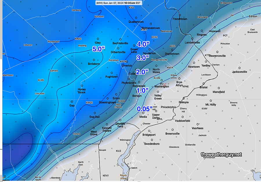
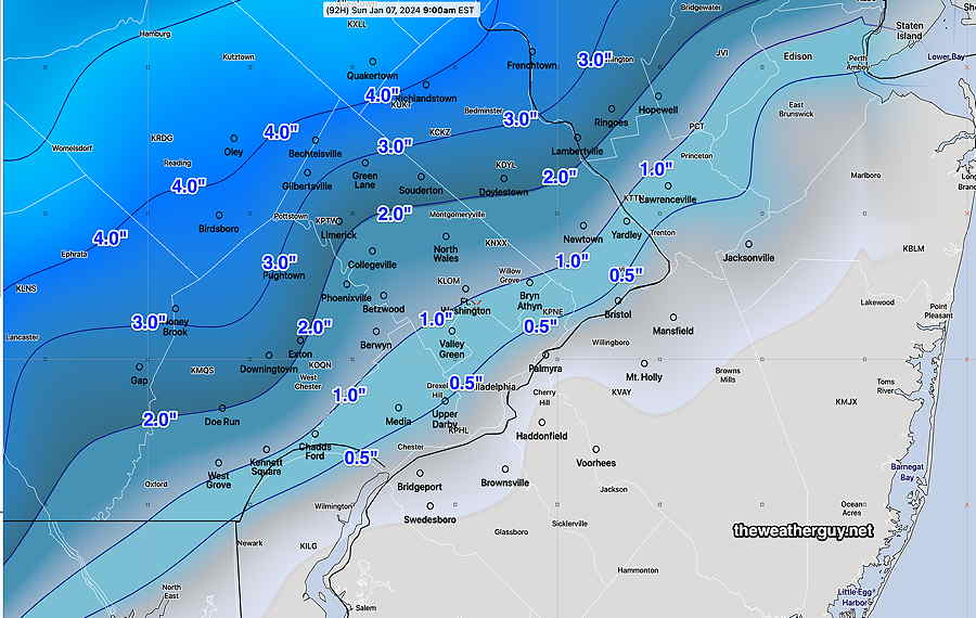
Here’s the very latest model blend (NBM) snow forecast—
Updates tomorrow.
Posted Thursday 01/04 @ 5:13 PM — There are some unexpected changes in the forecast, based on this afternoon’s models.
It now appears the low snow totals that had been consistent across models may need to be revised upwards. Both this afternoon’s GFS and NAM show the storm undergoing intensification Sunday afternoon with the possibility of prolonged snowfall from wrap around precipitation.
Specifically, the water equivalent precipitation that had been forecast (about 0.6-0.9″ water) is now up to 1.2″ water equivalent.
Instead of having the precipitation end around daybreak Sunday, the latest NAM and GFS has heavy precipitation continuing into early afternoon—
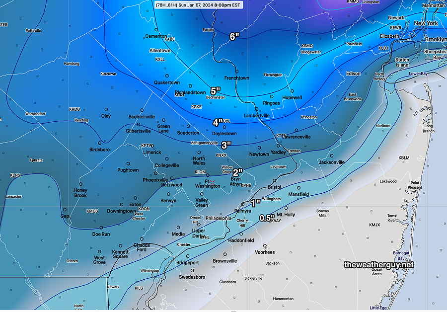
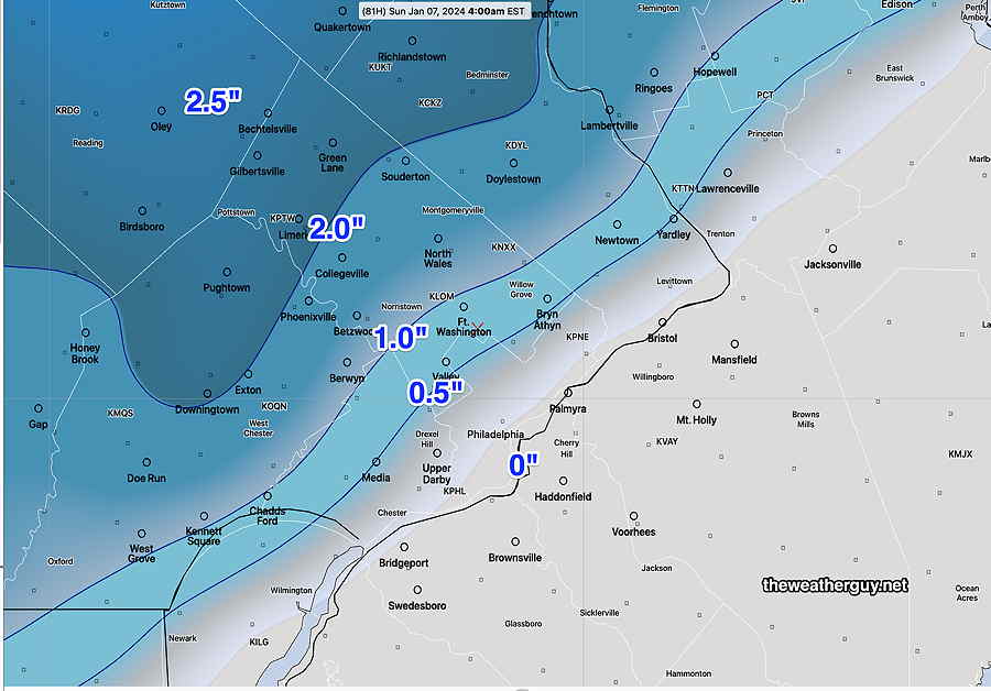
Here’s the latest NAM snow totals.
So, what looked to be a straightforward warm-storm snowfall is now possibly shaping up to be more of a forecast challenge with greater snowfall possible. A mix of marginal surface temperatures, high precipitation rates (dynamic cooling) is going to make accurate snowfall forecasts incredibly challenging
This may be just a glitch in this 18z run of the models, but it’s going to be more interesting than I thought. Stay tuned.
Weekend Storm Update – Thursday Edition
Posted Thursday 01/04 @ 10:18 AM — The “model blend” (NBM model) does a major update of its precipitation forecast four times daily. The most recent was the 13z model run.
Here’s the latest snow totals by Sunday—
Posted Thursday 01/04 @ 6:37 AM — Last night’s models (00z and 06z) continue with the following trends—
• Light snow moves in between noon and 3 PM, earlier in southwest Chester county.
• Snow changes to sleet in some areas by 6-7 PM, according to the NBM and NAM —
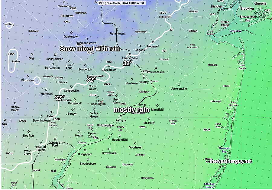
• In NJ, the city, and northwest immediate suburbs, little to no accumulation by Sunday morning.
• Areas northwest and far northwest will have some accumulation (see below)
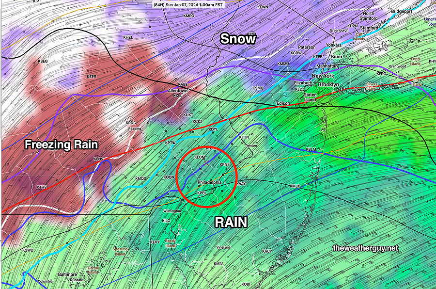
• Wrap around flurries, snow and rain showers Sunday.
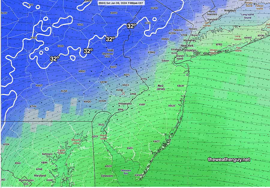
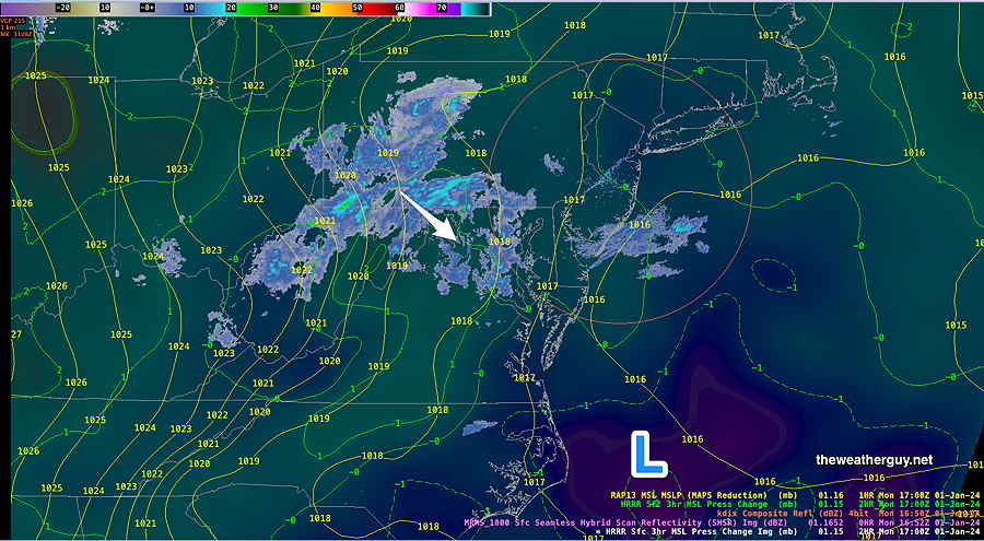
NAM at 7 PM Saturday—
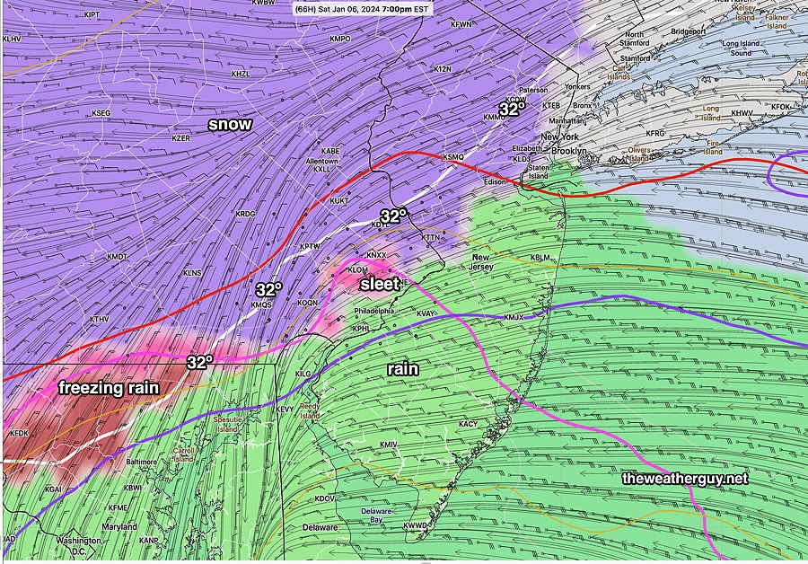
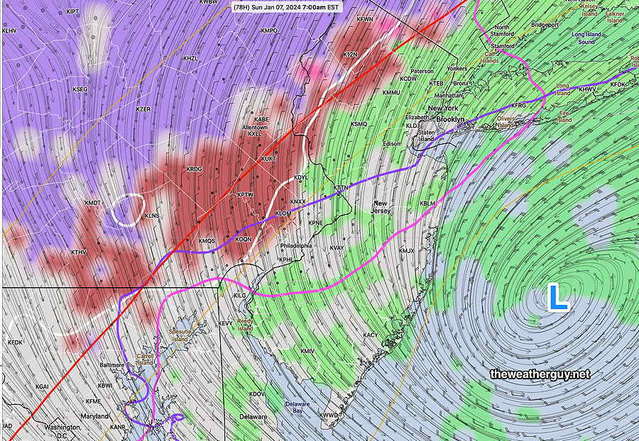
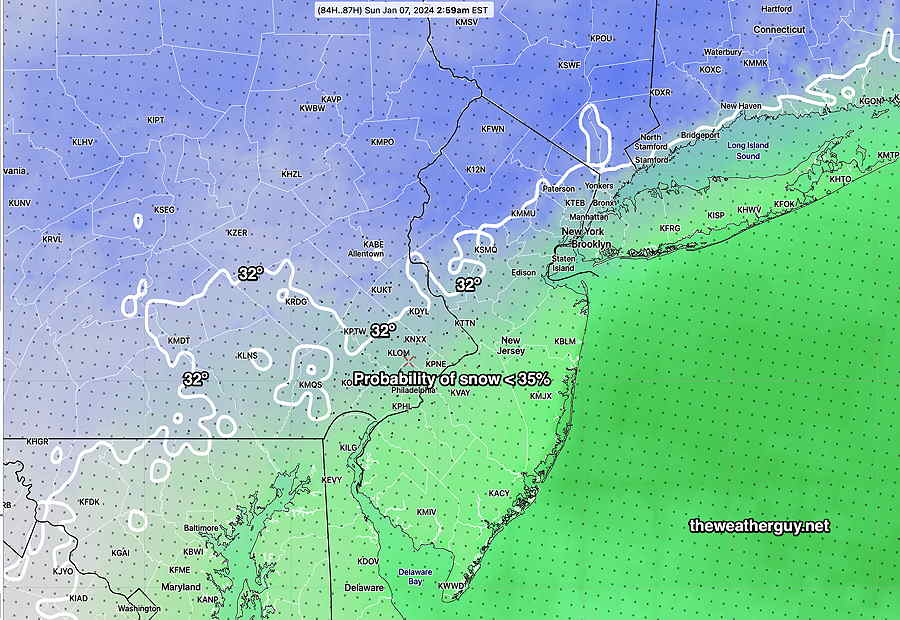
By 7 AM Sunday morning, the storm will be moving away. Wrap around mixed precipitation continues—
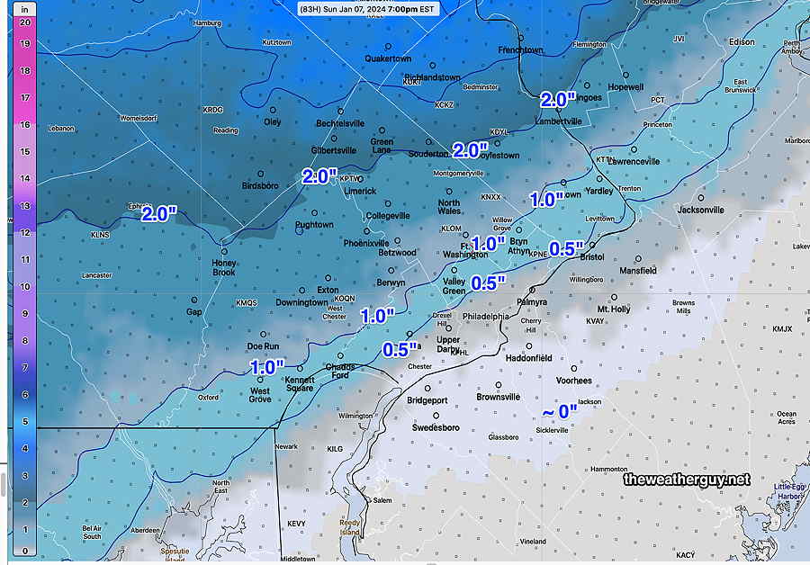
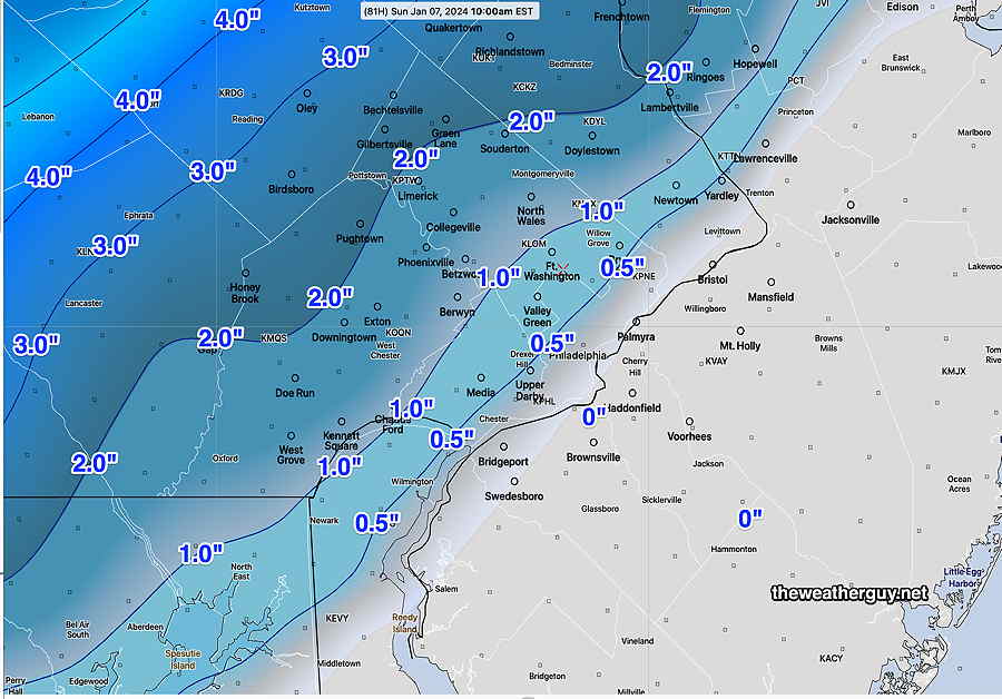
NAM snow totals by 10AM Sunday—
Canadian RGEM snow totals are somewhat higher with a sharper gradient —
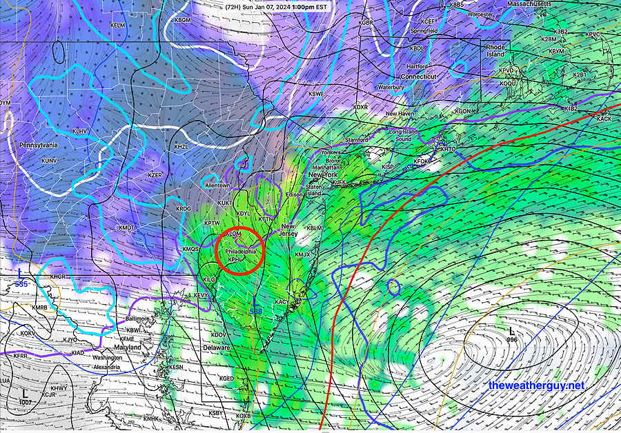
The next big fine tune in the storm forecast will occur in the 48 hour time frame, where numerous other high resolution model forecasts come into range (HREF, HRRR, HRDPS, NAM-NEST). So Friday’s 06z and 12z forecasts available Friday morning, should seal the deal.
Next update later this afternoon, about 5:30 PM
Weekend Storm Update
Posted Wednesday 01/03 @ 10:06 PM — Tonight’s NAM forecast extends into Sunday morning. Let me just preface that this model is not the state of the art, but over the years, it’s done very well with snowstorms.
At 3 PM, it’s mostly snow, except rain in NJ —
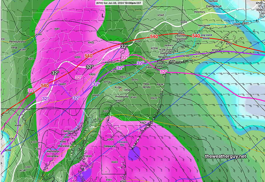
By Saturday 10 PM, it’s changing over to rain—
By near daybreak Sunday, here’s its accumulation totals—
These numbers will likely change by tomorrow, but the general trend of snow –> mix –> rain is shared by numerous other models.
Updates tomorrow.
Posted Wednesday 01/03 @ 6:11 PM — The storm is just entering into the forecast range of some of the higher resolution models— NAM and the RGEM (84 hours).
Regular readers of this blog know my mantra, “Never ignore the NAM“, when it comes to snowfall here. Since the storm has just entered the forecast range of the NAM, here’s what I’ve been waiting to see—
The next NAM becomes available about 9:40 PM tonight. I’ll update here about 10 PM.
Posted Wednesday 01/03 @ 5:38 PM — Update with the latest GFS model, just available—
Posted Wednesday 01/03 @ 5:17 PM — The trends that began yesterday continue with the Nor’easter expected to move in Saturday into early Sunday.
• After a start with light snow and flurries about 1-2 PM Saturday, snow will become somewhat heavier, but will begin mixing with rain during the late afternoon or early evening. There’s simply not enough cold air with this system.
• A changeover to mostly rain will occur before midnight Saturday. Most of the area will be mostly rain. There may be about an inch or so by midnight before the changeover.
The latest ECMWF shows temperatures above freezing by 10 PM Saturday at critical levels of the atmosphere—
By 3 AM and likely sooner, it’s mostly rain —
Saturday into Sunday Storm
Update Wed 1/03 1:42 PM — A quick mobile update. I got a peek at the new GFS and the trend towards more rain is appearing definite. Snow totals an inch or less in the city. I’ll be updating about 5:30 PM with additional new models and graphics.
Posted Wednesday 01/03 @ 8:32 AM —
The expected storm Saturday into Sunday should be entering the forecast range of the shorter range models (84 hours) later today. I’ve reviewed the latest models from last night. Here are the trends, somewhat similar to last night’s update.
• The snow starts earlier, sometime early afternoon, but with some snow flurries possible in the morning. Starting as snow, it will change and mix with rain in most areas south and east as shown below, possibly changing back to snow before ending. The NBM show’s little to no accumulation—
Incredibly, the latest NBM shows NO SNOW accumulation in most areas in around Philadelphia due to a changeover to rain.
The final word isn’t in yet… the ECMWF was somewhat colder, as was the GEFS.
I’ll update later today, when the storm comes in range of the NAM and Canadian RGEM higher resolution models.
Wednesday Forecast Update
Posted Tuesday 01/02 @ 5:55 PM — It appears that Wednesday will start sunny and cold, but clouds will move in during the early afternoon ahead of another system, expected to pass to our south. A few snow flurries (non-accumulating) looks possible for early Thursday morning.
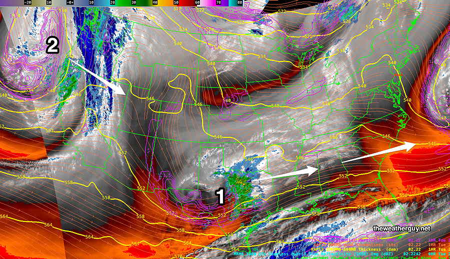
Current Water Vapor image
Forecast Update
Posted Tuesday 01/02 @ 9:37 AM — No change in Tuesday’s or Wednesday’s forecast.
Tuesday Outlook
Posted Monday 01/01 @ 7:34 PM — The sun makes a much needed appearance on Tuesday. After a cold morning, temperatures are expected to warm up to the lower 40s by 3 PM.
It looks like a storm will likely miss us and move east of us late Wednesday into Thursday. The weekend looks interesting.
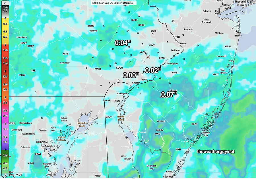
It should remain cloudy much of the remainder of the day, perhaps with a brief break in the cloud cover. As forecast, much of the rain will miss the immediate PHL area.
Previously Posted Sun 4:50 PM —
New Year’s Day Forecast
Happy New Year! The persistent upper level low will drift over us and a very weak secondary low pressure system will form off of the Delmarva coast. (Yes, this forecast has changed from this past Friday.)
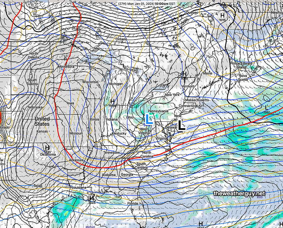
For Monday, considerable cloudiness with light, spotty showers expected, more to our west and to our east in NJ. Philadelphia and its immediate suburbs may have the least rain, about 0.01-0.02″. High low 40s, which is near to slightly above season average. Winds light, increasing towards evening.
Skies clear on Tuesday, but it will be colder than average.
Looking Ahead
Several areas of coastal low pressure are expected to develop in the coming days— one late Thursday and another on Sunday afternoon.
With temperatures near to slightly above normal , we’re on the edge of a few possible light snow/dustings in far northern and western suburbs. As mentioned over past weeks, the pattern may be changing the end of this week. (see my Winter Outlook Posts, updated today, for more speculation.)
Things have trended a bit colder and the storm next Sunday needs to be watched, although right now, it looks like it will either be too warm or to far to the east for snow here.