Updated Thu 08/10 @ 7:58 PM — Friday looks quite nice with temperatures in the low to mid 80s. Sunshine through high cirrus clouds for most of the day.
Thursday Update
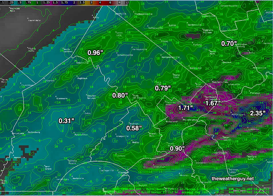
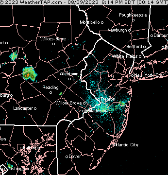
Thu 7:47 PM Forecast Review —So how much rain did we get?
MRMS radar- rain gauge estimated total amount of rainfall on Thursday. (Click on image for a larger view.)
Most models over-estimated the rainfall today. Last night’s 06zHRRR came the closest in predicting the axis of heavy rain. This morning’s HRRR didn’t do as well, probably due to inadequate model spin-up time.
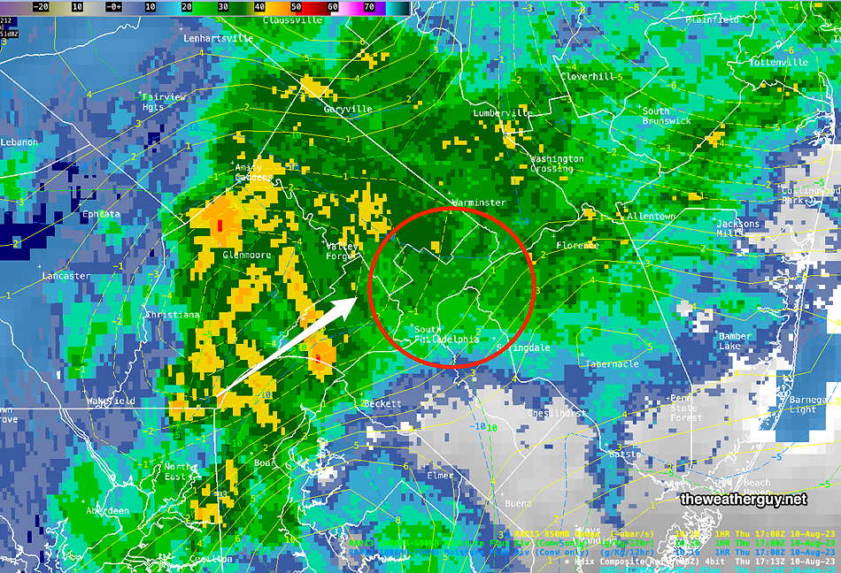
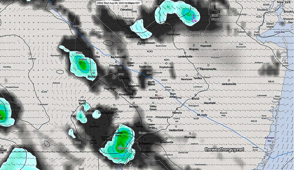
Thu 1:54 PM Forecast Review — Based on current radar trends and RAP data, I don’t see the severe weather occurring in our immediate area. Probably just 0.5-1″ in the immediate PHL area.
Radar about 1:20 PM (Click on image for a larger view.)
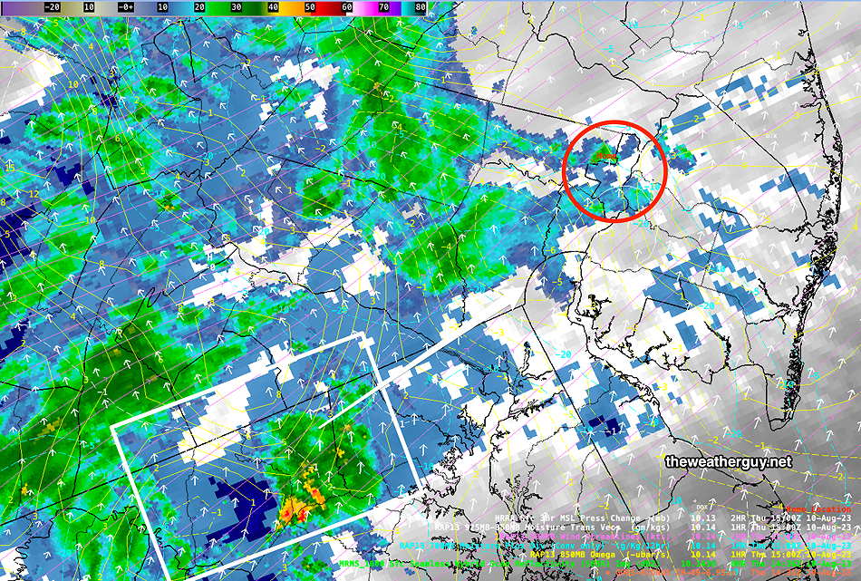
Updated Thu 08/10 @ 10:58 AM — Light sprinkles have moved in earlier than forecast. The main activity is still to our southwest—
Thursday Forecast Clarified
Updated Thu 08/10 @ 8:05 AM — Severity Parameter Comparison Table for Today– Allows comparison to recent severe events.
Severity Parameter (HRRR)
Sept 1 , 2021 Tornado Outbreak (example of highly severe)
Severity Parameters Impact: ⚑ indicates favors Severity⚐ indicates Possible Severity ↓ indicates works against Severity ⇩ Significant, but less impact
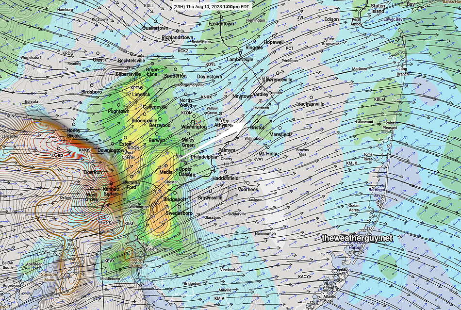
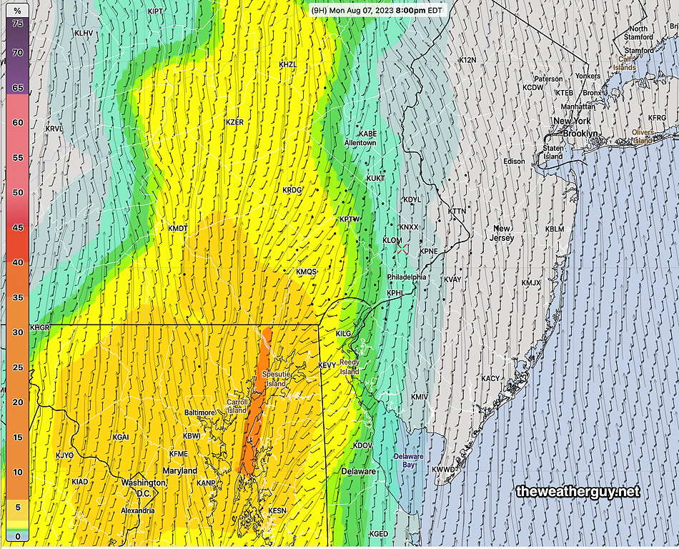
Update Thu 8/10 7:37 AM — Last night’s 06z models have come together to allow for better forecast accuracy. It appears that CAPE values will be higher than previously forecast. The chance for strong to severe thunderstorms has increased for today. The biggest issue will be heavy rainfall in some areas, on the order of 1-2 inches.
Per the GFS (which had the best timing for Monday night’s storms) showers have already moved into far western parts of Montgomery county, but are heading northward, away from the city.
The main activity moves into immediate Philadelphia area between 11 and noon. Peak activity is around 2 PM, lasting on and off until 5-6 PM.
Thursday Outlook- More Thunderstorms
Update Wed 8/09 11:11 PM — Tonight’s high resolution models have a wide spread of forecasts. Some have heavy rain east in NJ, some have heavy rain northwest of the city. You get the idea. We simply don’t know where the heaviest rain will fall. Many areas may only get about 0.6”. A few may get 1.5”. Severe storms look less likely, with CAPE values unimpressive.
I’ll try to pin it down tomorrow morning.
Updated Wed 08/09 @ 5:15 PM — A rapidly moving system will move in from the west on Thursday. Showers and thunderstorms are likely to move in from the southwest from mid to late morning and linger through much of the afternoon. Some moderate to heavy rain expected in some areas.Some strong storms also appear likely, but CAPE values are in the 500-600 Joule/Kg range rather than the 2500 range of this past Monday night.
The latest HRRR shows an area of significantly elevated severe parameters between 11 AM and 2 PM in the Philadelphia area, while the NAM-NEST shows the most likely areas for strong (to severe) storms will be south into Delaware and much of the NJ Shore during the later afternoon. I generally go with the HRRR model with these sort of things.
Here’s the 18z HRRR—
Today’s 18z HRRR shows significantly elevated vertical shear (color shading) and significant helicity (brown rounded contours). Storm motion vectors (short arrows) are aligned with the direction of the shear (longer streamlines), increasing likelihood of stronger storms. CAPE values (not shown) are not all that impressive, due to lack of sunshine. Still enough CAPE to allow for thunderstorm development.Lower CAPE may put a lid on the severity of the thunderstorms. White arrow shows expected storm track. (Click on image for a larger view.)
Updated 9:00 PM It looks like a few storms popped tonight—
Wed 5:13 PM Forecast Review — The isolated shower/storms haven’t materialized here except just north of Allentown. This afternoon’s NAM-NEST continues to forecast showers moving into our area between 9 and 11 PM. A low confidence forecast.
Wednesday Forecast Update
Updated Wed 08/09 @ 9:40 AM — The 06z HRDPS shows an upper air disturbance rotating through our area between 4 and 7 PM today with a few widely scattered/isolated showers and clouds. The latest 12z HRRR shows only a bit of activity, but we’ve seen the HRRR underestimate these situations over past weeks.
06z HRDPS shows widely scattered to isolated showers moving through at 5 PM. As always, the exact location of the model-predicted showers is just a rough guide, not to be taken literally. (Click on image for a larger view.)
Wednesday Outlook
Updated Tue 08/08 @ 7:58 PM — A beautiful day in store for Wednesday. Sunny, low humidity. A bit windy/breezy in the early afternoon. High 85º-86º.
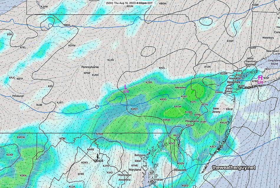
A disturbance in Nebraska will bring showers and thunderstorms to us by Thursday afternoon.
RGEM forecast 3 hour precipitation at 4 PM Thursday. (Click on image for a larger view.)
Tuesday Outlook
Updated Tue 08/08 @ 9:08 AM —Departing low pressure at the surface and an rapid increase in cold air aloft will result in instability cloudiness and windy conditions today.
NBM cloud cover (dark) with standard deviation (contours) (Click on image for a larger view.)
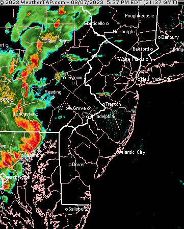
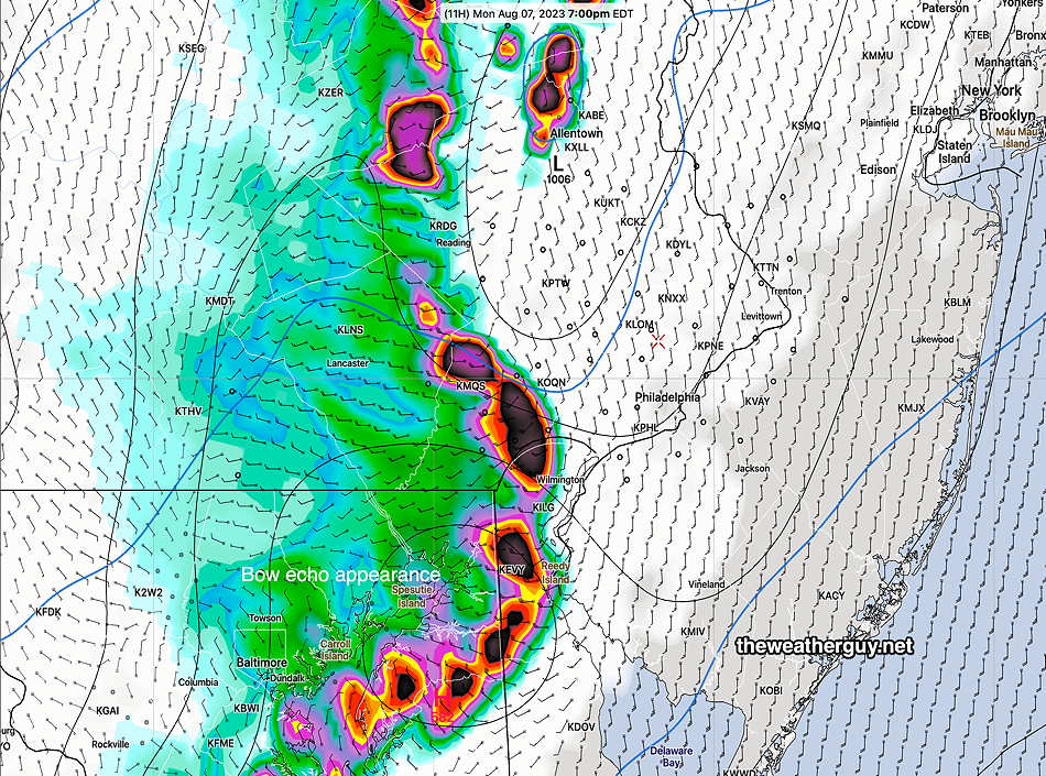
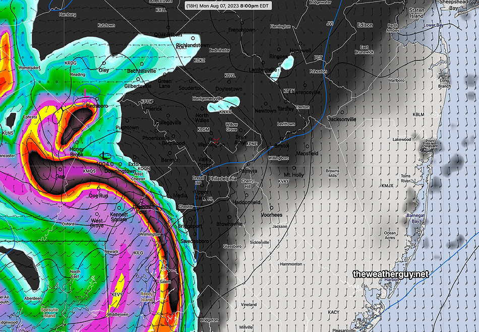
Mon 09:32 PM Forecast Review — I think the models did pretty good today. The GFS correctly got the earlier timing. The HRDPS and the HRRR correctly predicted the bow echo appearance. The storms, while still strong, did reduce in intensity as they moved into NJ.
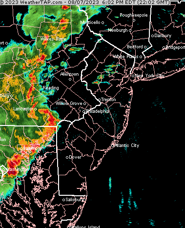
Update Mon 8/07 6:31 PM — The bow echo, predicted by the HRDPS early today, seems to have developed—
Update Mon 8/07 6:01 PM — Evidence of rotation in Lancaster county visible on current radar
Severe Weather Update
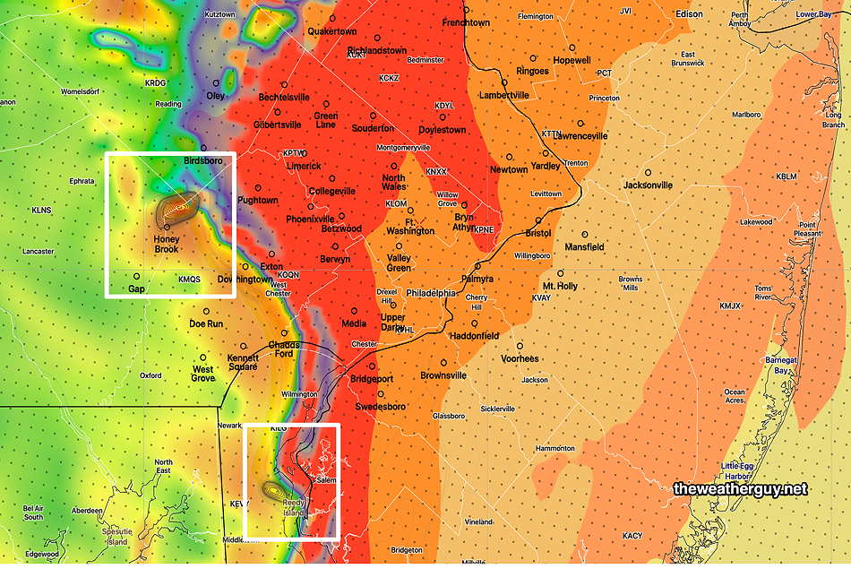
Updated Mon 08/07 @ 5:34 PM — The latest NBM continues the trend of showing storms at their strongest in western suburbs with reduced severity as they move into NJ. The exception in NJ where severity continues – areas south of Vineland and Salem and Cape May Counties.
Severe Parameter Table for this Storm
Updated Mon 08/07 @ 3:48 PM — My regular readers know I like to prepare this table of severe parameters to compare with known other severe events. Today’s severity table is impressive.
Severity Parameter (HRRR)
Sept 1 , 2021 Tornado Outbreak (example of highly severe)
Recent 4-1-23 Tornadoes (Example of severe)
Recent 08-07-23 18z HRRR Bow Echo
08-10-23 Today’s 06z HRRR & Impact
Notes
CAPE Joules/kg
3500-4200 ⚑⚑⚑⚑
2100 ⚑⚑
2600 ⚑⚑
1200 ⚐ ⚐
Helicity m^2/s^2
1350 ⚑⚑⚑⚑⚑
655 ⚑⚑
726 ⚑⚑
560 ⚑
Vertical Shear 1/sec
40-46 ⚑⚑⚑
40-45 ⚑⚑⚑
30 ⚑
32 ⚑
Precipitable Water
2.7″ ⚑⚑⚑⚑
0.83” ↓
2.1″ ⚑⚑
2.3″ ⚑⚑
Heavy rain potential
Lifted Index º K
minus 6º ⚑⚑
minus 9.3º ⚑⚑⚑
minus 9.9º ⚑⚑⚑
Minus 4.4º ⚐
HRRR Hail inches
1.9 ⚑⚑
1.4 ⚑
1.8 ⚑⚑
1.6 ⚑
Peak Wind Gusts mph
40-50 ⚑⚑
40-50 ⚑⚑
65mph ⚑⚑
32mph ⚐
Storm Motion Shear Vector Alignment
Aligned – ~ 90º ⚑⚑
Almost aligned ⚑⚑
aligned ⚑⚑
Somewhat aligned ⚐
250 mb Jet Stream Wind mph
63 ⚑
135 ⚑⚑
74 ⚑
95-104 ⚑⚑
Severity Parameters Impact: ⚑ indicates favors Severity⚐ indicates Possible Severity ↓ indicates works against Severity ⇩ Significant, but less impact
Monday Severe Storm Threat Update
Updated Mon 08/07 @ 3:28 PM — The latest HRRR (18z) shows the following trends:
Activity begins far western sections around 6 PM
Activity moves into immediate Philadelphia area between 7 and 9 PM
Strongest severe threat is in western suburbs, but strong to severe storms possible in and around Philadelphia and across into NJ.
Latest HRRR shows storms continuing through 11 PM
Significant Hail threat across the entire region.
Tornadic activity possible in Lancaster county, far southern Chester county into Delaware and Maryland.
Monday Severe Storm Threat
Updated Mon 08/07 @ 12:58 PM — The current version of the NBM model (version 4.1) features a new parameter, 4 hour Tornado Probability. The latest NBM shows an area to our west having an elevated probability of tornado formation at 8 PM. Note that this area is west and south of the immediate PHL area.
Today’s 15z NBM shows elevated 4 hour Tornado Probability to our west and south. NBM model version 4.1 was released early 2023. This is the first time I’ve seen this parameter noticeably elevated in our general area since its inception. (Click on image for a larger view.)
This morning’s models continue with a range of start times for the storms. As early as 5:30 to 6 PM (GFS) and closer to 8-9 PM (HRDPS) for the immediate Philadelphia areas.
The trend noted earlier, that the most severe storms remain to our south and west, continues. However the latest models do show a few strong storms near Philadelphia and just east into NJ.
The latest 15z HRRR continues to show some weakening of the line of storms as it moves east into NJ.
Monday Severe Storm Threat
Updated Mon 08/07 @ 10:30 AM — additional graphics for tornadoes and hail added below.
Updated Mon 08/07 @ 9:49 AM — The 12z HRRR has become available. The 12z model runs (and the 00z model runs) utilize direct upper air measurements with weather balloons (and radiosondes) launched globally. While upper air measurements can be obtained with satellite imagery and radar, the direct measurements have an advantage.
The 12z HRRR has supported my impressions from last night: the severity of the storms weaken as they move through Philadelphia and eastward into NJ. But much can happen before moving across the Delaware River.
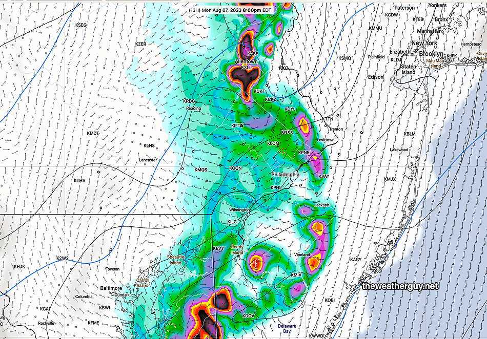
The HRRR shows a bow-echo type appearance at 7 PM, west of the city—
12z HRRR instantaneous PRATE (precipitation rate) at 7 PM. (Click on image for a larger view.)
By 8 PM, the change in intensity is is apparent—
12z HRRR at 8 PM. (Click on image for a larger view.)
The earlier 06z HRDPS is most impressive with its bow-shape image which also weakens as it moves eastward—
Today’s earlier 06z Canadian HRDPS shows an impressive bow-shaped precip signature of severe weather. (Click on image for a larger view.)
Assuming the reduction in intensity occurs, much can still transpire between 7 PM and 8 PM. The takeaway from this is one might expect less intensity east of Philadelphia. The greatest threat of severe weather is from Philadelphia westward and especially southwardtowards Delaware and southern South Jersey.
Tornado Potential — The HRRR is showing isolated tornadic potential—
HRRR high helicity in areas of precip. (Click on image for a larger view.)
Hail
12z HRRR Areas of increased risk of large size hail. (Click on image for a larger view.)
Monday Severe Storm Threat
Update Mon 8/07 8:22 AM — The jet stream/upper air dynamics that had suggested weakening of storms from Philadelphia and east no longer appears to be the case. That said, the most severe threat is still western suburbs of Philadelphia and southern areas near Wilmington Delaware and South Jersey. Storm threat is about 6-8 PM (HRRR) and 8-10 PM (HRDPS.
Last night’s 06z models are showing a “bow echo” signature of a severe storm line to the west Philadelphia.
Some scattered storms possible as early as 3-4 PM, ahead of the main line of storms.
Look for an update here before 10AM with the latest 12z HRRR data.
Monday Storm Outlook
Update Sun 8/06 10:41 PM — I know this flies in the face of some of tv/radio forecasts predicting severe weather later Monday, but a number of models show the heavy activity late Monday moving to our north and south, weakening in the immediate Philadelphia area. (The upper air dynamics become unfavorable in our immediate neck of the woods.) Something to keep in mind. Too early to be certain.
It also looks like scattered storms are possible earlier in the afternoon, ahead of the main group of storms.
Updated Sun 08/06 @ 7:37 PM — An approaching warm front will bring showers and thunderstorms tonight, after midnight in the immediate Philadelphia area and an hour or so earlier southwestern suburbs.
Currently the storms are in the Baltimore / Washington area—
Combined Water Vapor and Radar image at 7 PM with superimposed RAP model low level winds and moisture convergence. The heaviest rain will move up to our west tonight, but storms here can still bring some heavy downpours. (Click on image for a larger view.)
Some areas will receive heavy rainfall tonight, especially areas northwest of Allentown and southern Chester County.
Showers may linger until 8 AM Monday.
Some models have clouds breaking for periods of sunshine by Monday afternoon, but some models have clouds lingering with ongoing scattered showers during the day. Probably somewhere in between.
There’s a range of model timing for the thunderstorms with the approaching cold front Monday late afternoon and evening.
The GFS, HRDPS and RAP have 5-6 PM as the start of some heavier storms in Philadelphia and immediate suburbs. The HRRR was closer to 7-8 PM Monday evening. Heavy rain and strong wind gusts are possible with these storms.
Some activity may diminish in intensity as it moves through Philadelphia, but that’s not a certainty.
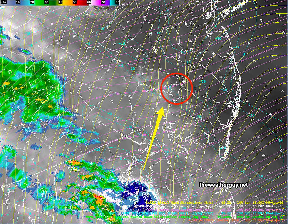
Updated Sun 08/06 @ 9:14 AM — A southerly to southeasterly flow of warmer and more humid air will affect our weather today.
A warm front is taking shape for Sunday night (after midnight) that will bring showers and thunderstorms between 1 AM and 6 AM. The warm front and cold front are easily visible on water vapor imagery.—
Satellite Water Vapor Image Sunday morning shows the warm front (1) and the cold front (2) that will affect our weather Sunday night (after midnight) and Monday evening. This water vapor image (channel 9) specifically looks at the temperatures of the mid and upper levels of the atmosphere; it does NOT capture reflected light from clouds. The orange areas are warmer. On Monday, we’ll be in the narrow area orange sandwiched be the warm front and cold front. (Click on image for a larger view.)
This is the sort of scenario where thunderstorm might wake you up tonight.
After a very humid and sultry day Monday, very strong thunderstorms are likely late afternoon into evening Monday. (5 PM through 10 PM)
Plenty of CAPE, instability and helicity will be present for some strong to severe storms with a slight-marginal tornadic possibility. Unlike the past two thunderstorm threats, this one does not look like it will fizzle out.
Stay tuned for updates.
Updated Sat 08/05 @ 5:54 PM — Today, we had clouds and sunshine through a significant shield of high level clouds. Some people might casually describe today as having been sunny, but meteorologically, it correctly goes down as ‘mostly cloudy’ in the official PHL airport record.
Sunday may start cloudy very early, but we’ll have more sunshine than today through high level clouds and there will be fewer mid level clouds. High temp 87º- Blue Bell, 88º-Philadelphia. Increased humidity.
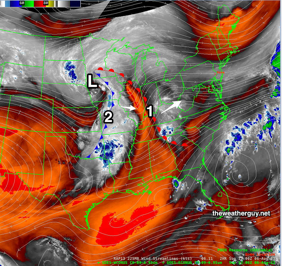
Current Satellite WV image shows complex system in Midwest to approach Sunday night into Monday. (Click on image for a larger view.)
Clouds move in from an approaching system about 4-6 PM. Showers after midnight Sunday. Showers on Monday with a high chance of thunderstorms Monday evening. Dew points in the low 70s Monday!
Previously Posted Fri 8:16 PM —
Some strong showers and storms near Harrisburg this afternoon have been falling apart as they move east. A few light showers are still possible this evening into tonight in our area.
Weak high pressure builds in for the weekend, but the remnants of the front will not be very far southeast of us. Very weak waves of low pressure will develop on the boundary. A bit more high cloudiness at times is all that is expected. Another system approaches Sunday evening from the west bringing clouds late Sunday afternoon.
Saturday
Some cloudiness early, then becoming partly cloudy/partly sunny. Sunshine through considerable high cloudiness (cirrus) is expected due to moisture flowing back aloft from the circulations to our southeast.
Today’s 18z GFS shows weak surface level wind cyclonic flow and convergence along the weak frontal remnants to our south and east. May cause more cloudiness than currently forecast. (Click on image for a larger view.)
High temperature 84.8º sd 1.1º ( NBM model— location Blue Bell, PA)
Sunday
Periods of sun and clouds. (An easterly wind flow may bring more clouds than currently expected.)
High temperature 86.6º sd 1.6º ( NBM model— location Blue Bell, PA)