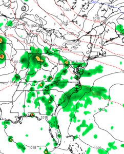
[su_note note_color=”#d9f2da”]Fri 11pm Update: Tonight’s NAM shows showers before 8am Saturday, then dry until later in the afternoon with showers from PHL and south. Tonight’s NAM also keeps Sunday dry until Sunday evening. [/su_note]
This weekend’s weather is going to depend greatly on your location— a weak front will move south through PHL late Saturday and will orient west to east just south of Philadelphia. Like the past few weekends, high pressure will nose in from the northeast on Sunday— an easterly wind will keep temperatures cool on Sunday.
Currently the models are in somewhat reasonable agreement that most of the disturbances riding along the boundary this weekend, especially Saturday, will be in Delaware and Maryland and may just reach into extreme southern Pennsylvania and southern NJ. Those are the areas where widely scattered showers and thunderstorms are expected. Areas north of PHL— Bucks County and Upper Mongomery county look to be relatively rain-free.
So Saturday will be a mix of sun and clouds; showers will develop late afternoon, mostly to our south. High 83.

For Sunday, the NAM keeps our area dry with a mix of clouds and sun; the north-south dichotomy will remain. An easterly wind will keep temperatures cool; with a high of 74.
BUT, there are large differences with the model forecast for Sunday. The GFS pushes more precipitation into our area on Sunday into Sunday evening while the NAM shunts it south into Delaware and Maryland. With such LARGE differences, we’ll have to wait to make a better call.
