Posted Sunday 12/17 @ 3:10 PM — It’s looking like 3-4 inches of rain (even 5″ in a few spotes just to our west) will fall over a large area, according to the majority of this morning’s models.
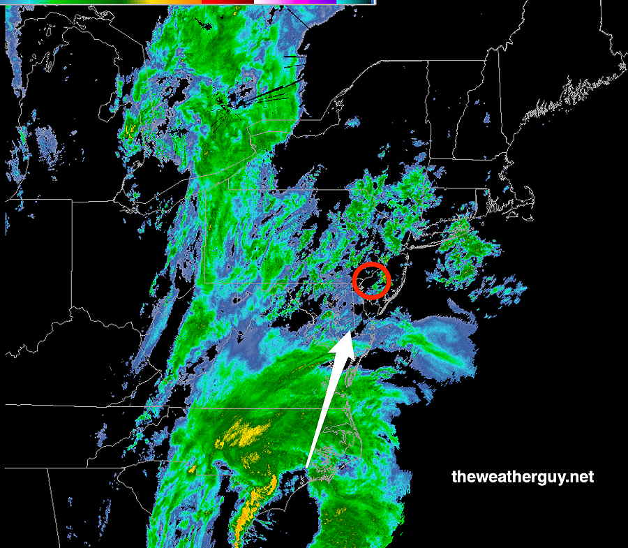
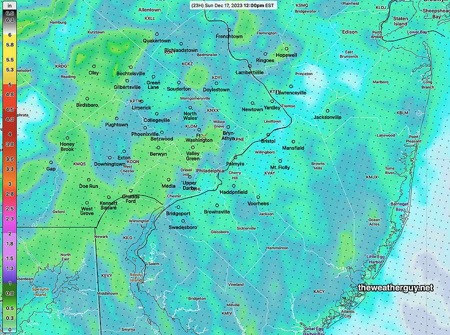
Here’s the 3 PM MRMS radar. The heaviest rain is expected between 1 and 4 AM —
MRMS radar at 3 PM Sunday.
Sunday Storm Update
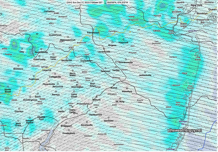
Posted Sunday 12/17 @ 9:33 AM — After reviewing the latest model guidance, the forecast remains pretty much intact. Very light drizzle of increasing intensity is visible on radar moving up from the Cape May area. A gradual increase in dampness as the morning proceeds.
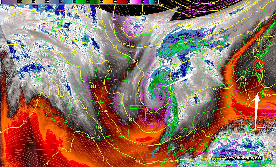
The current setup, via satellite water vapor imagery—
Current satellite water vapor image with superimposed RAP model 500-1000 mb thickness lines (yellow), jet level wind streamlines (orange contour-arrows) potential vorticity (fine violet contours) and superimposed MRMS radar. The main storm is far to our south moving almost directly towards us. (Click on image for a larger view.)
Here are the salient points regarding this storm—
light scattered drizzle, increasing late afternoon
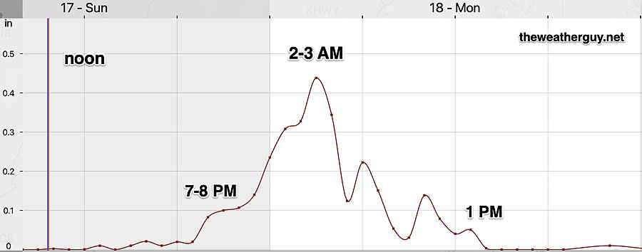
heaviest rain 2-3 AM tonight
rain taper late Monday morning ends after 1-2 PM Monday
highest winds after midnight and especially 2-3 AM into Monday morning. Wind gusts 40 mph with some models showing 50mph.
Snow flurries, especially north and west daybreak Tuesday. Possibly a coating northwestern suburbs.
Here’s the hourly forecast rain rate in inches per hour (NBM model)—
NBM Precipitation rate (Blue Bell) in inches/hour. Greatest rainfall intensity (and winds) 2-3 AM (Click on image for a larger view.)
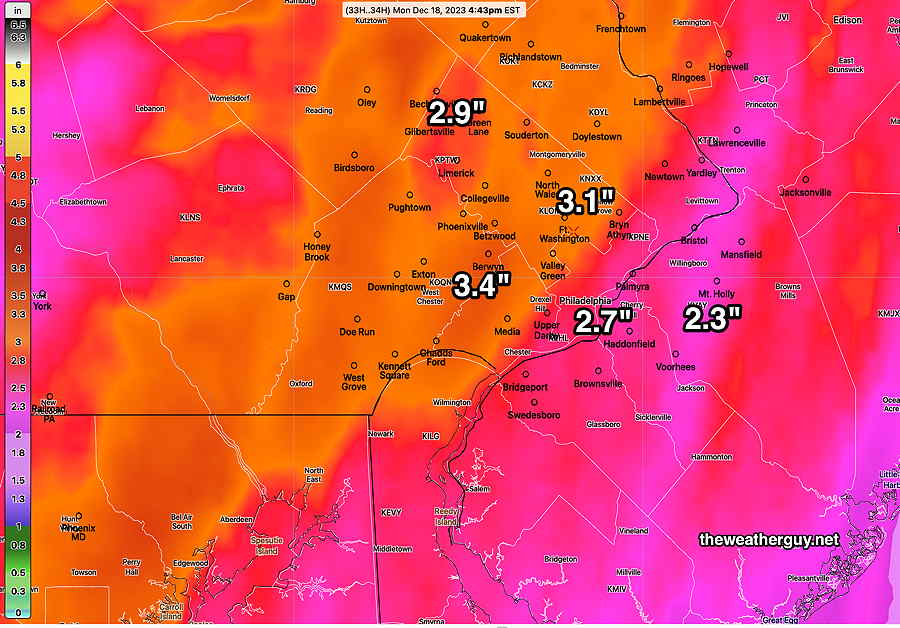
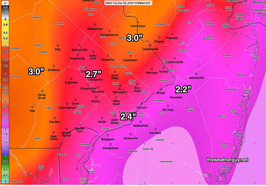
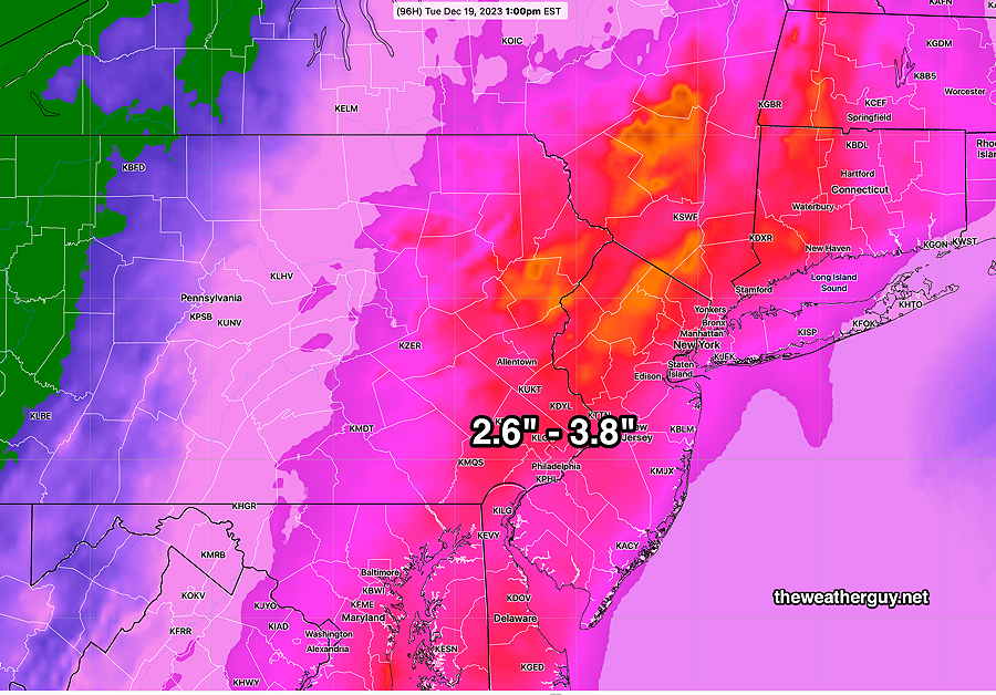
Total Rainfall expected—
Today’s 12z NBM total precipitation forecast. Some models show areas of 4″+ Click on image for a larger view.)
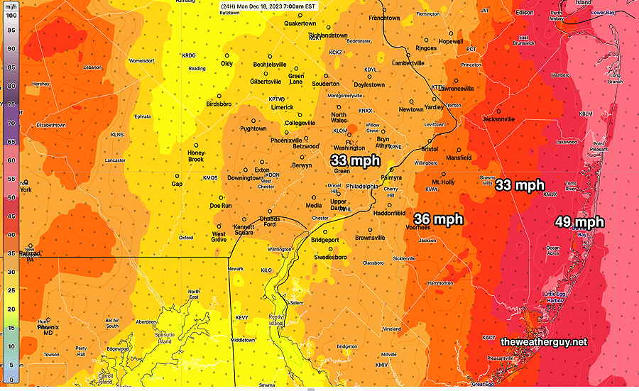
Wind gusts—
Sunday Forecast Update
Posted Saturday 12/16 @ 4:55 PM — The high cloud cover today was less than forecast and the NAM-NEST was one of the few models that got this right today (but discounted by me) .
The NAM-NEST continues to forecast showers and drizzle as early as the early to mid morning Sunday, and because of its accuracy today, I’m going with it for Sunday. It’s supported somewhat by the latest ECMWF and to some extent, the latest GFS, but the rainfall it’s predicting early is quite enhanced—
NAM-NEST shows showers and drizzle starting before daybreak and rainfall by noon Sunday is considerably more than several other models. Nonetheless, I’m going with it, based on its performance today. (Click on image for a larger view.)
The heavier rain starts between 5 PM and 7 PM Sunday evening. At that time, the main storm is still in South Carolina moving north. By midnight, wind gusts increase to 40 mph.
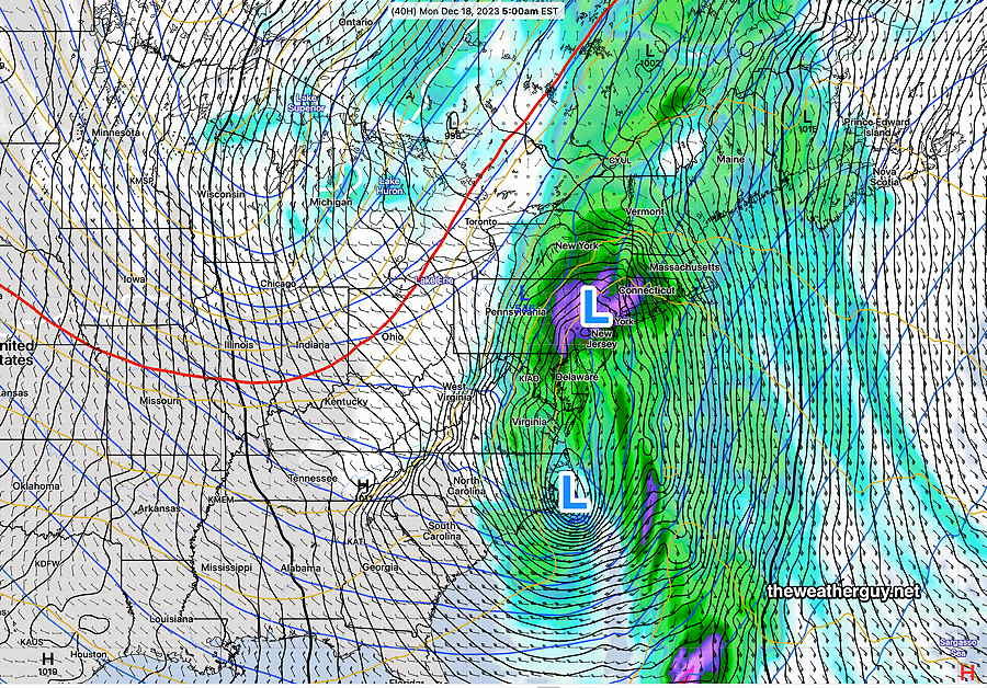
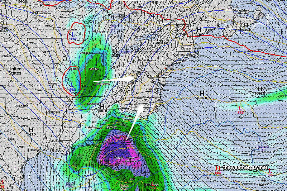
By 5 AM Monday morning, the low is an elongated two-center system right over our area—
Latest GFS (18z) shows a two center elongated low at 5 AM Monday. (Click on image for a larger view.)
The rain tapers off after noontime Monday. Total rainfall (GFS) —
Today’s latest GFS (18z) shows total rainfall expected. (Click on image for a larger view.)
Forecast Update
Posted Saturday 12/16 @ 9:18 AM — The forecast is on track for today, Saturday, with increasing high cloudiness, especially by late afternoon.
The general trend of last night’s models continue with the rain of the main low pressure reaching us during the evening hours, and with light scattered showers and drizzle during the day Sunday.
The NAM-NEST is particularly aggressive (maybe too aggressive?) with the light rain/drizzle during the day Sunday —
The latest NAM-NEST has light showers and drizzle, even Sunday morning. Possible, but maybe too soon. (Click on image for a larger view.)
One trend I’m watching (hinted only slightly by the GFS and ECMWF) is a more westward track of the low, with the heaviest rain west of the city into central PA.
I’m particularly interested in this trend, since the still experimental RRFS model (now at version 0.7.7) shows a considerable westward track of the storm. (It’s more than likely that the RRFS is not ready for prime time, but I’m curious to see if it provides any insights. You can see the ongoing development notes of the RRFS model here. )
I’ll update later this afternoon with the latest.
Previously Posted Fri 6:42 PM —
An impulse in the middle of the US will merge with another over Florida and move up towards us on Sunday, resulting in a powerful storm directly over us. Here’s the current water vapor image showing the setup—
Current satellite water vapor image (Friday afternoon) with superimposed RAP model 500-1000 mb thickness lines (yellow), jet level wind streamlines (orange contour-arrows) potential vorticity (fine violet contours) and superimposed MRMS radar. (Click on image for a larger view.)
A deep and significant storm will be the result. The NAEFS which combines the GEFS and Canadian GEPS shows the sequence—
NAEFS forecast Sat night–> Sunday night–> Monday night. (Click on image for a larger view.) By Tuesday, we’ll have a closed upper low with very cold air over our area. (Click on image for a larger view.)
High winds and heavy rains expected.
Saturday
Sunshine through high level cirrus cloudiness. The high level cloudiness thickens later in the day. Light winds.
High temperature 53º ( NBM model— location Blue Bell, PA) High temperature 54º ( NBM model— location Philadelphia, PA) average to low level of uncertainty ± 1.5º
Previously Posted Fri 6:42 PM —
Sunday
Cloudy. Scattered light rain in the morning, becomes more widespread and heavier by 2-3 PM. Light winds, becoming windy in the evening.
High temperature 56º ( NBM model— location Blue Bell, PA) High temperature 58º ( NBM model— location Philadelphia, PA) average level of uncertainty ± 2.5º
Rain, very heavy, Sunday night into Monday morning. VERY WINDY!
By late Monday, becoming quite cold and windy. Possibly some snow flurries.
Total Rainfall—
NBM model total rainfall through late Monday. (Click on image for a larger view.)