Updated Fri 8/05 9:52 AM —We had some showers Thursday evening, more widespread than had been forecast by the models.
For today, Friday, there’s a range of forecasts, with many models showing little in the way of rainfall to as much as an inch. The trend is for not much. Timing varies from as early as mid to late afternoon, to storms moving through late evening and even after midnight.
I’m curious whether the new, experimental limited area model clarifies the forecast. It has maintained a forecast of a moderate cluster of storms early evening.
Updated Wed 9:38 PM — The forecast is unchanged for Thursday. Very hot and humid. A few scattered thunderstorms my pop up after 5 PM, but with low vertical shear, they won’t last long or cover much territory.
A cold front approaches on Friday. A large cluster of thunderstorms will develop in western suburbs and move into the city between 6 and 8 PM. Some heavy rain possible with these storms. Shear values will again be low, so we’ll have to see if the models are getting this right.
Update Tue 08/02 @ 8:20 PM — Not much happening except increasing heat. A weak front moved through about 1 PM today. A few isolated showers broke out with the frontal passage (not predicted by the models.)
The increasing temperatures for Wednesday and Thursday are well-advertised by the regular radio and TV media.
Here’s some specifics info for Thursday based on the current NBM model —
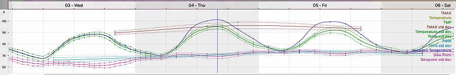
19z NBM Temperature Dew point meteogram for Blue Bell PA for Wednesday through noon Saturday. (Philadelphia tends to run a bit hotter by 2-3º) (Click on image for a larger view.)
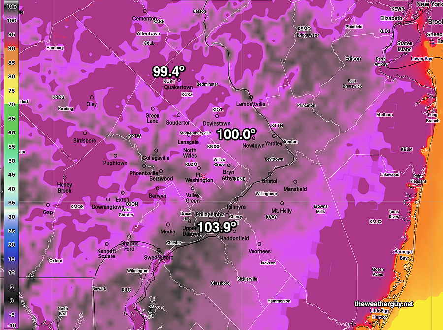
High Temperatures Thursday—
NBM forecast high temperatures for Thursday. The “±” temp is the standard deviation of the over 20 models that comprise the NBM. Most areas are over 95-100º (Click on image for a larger view.)
Here’s the NBM forecast Heat Index (“apparent temperature”)—
NBM forecast max HEAT INDEX (apparent temperature) for Thursday about 2:55 PM. Most areas over 100º (Click on image for a larger view.)
Next chance for showers/storms: possibly Thursday night, but most likely Friday afternoon and or evening.
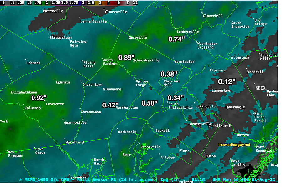
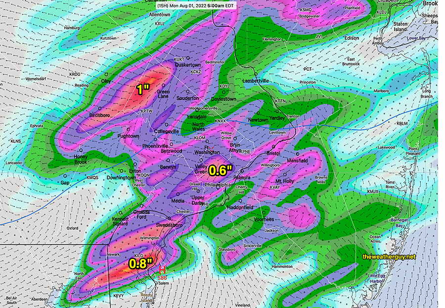
Update Mon 08/01 @ 1:21 PM — We finally had some large scale rain in the area last night, but amounts were overall only in the 0.4-0.6 inch range with some localized higher amounts and some areas with little—
MRMS 24 hour rain accumulation through noon Monday. (Click on image for a larger view.)
A weak front moving through Pennsylvania today (Monday) will fall apart as it moves towards the Delaware Valley with all showers associated with the front forecast forecast to die out.
For Tuesday and Wednesday: Temperatures will approach and exceed 90º but the dew points on Tuesday will drop during the afternoon and remain in the tolerable 60s on Wednesday.
The severe heat and humidity return on Thursday before a cold front slowly sinks south Thursday night with showers and thunderstorms possible. It’s possible that we’ll again see some anemic rainfall with this front.
Previously Posted Sun 5:45 PM —
The large hot air mass in Texas and the Midwest that has been making headlines for the past several weeks will be shifting northward and eastward and influencing our weather this coming week.
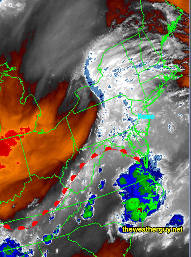
A warm front will move northward tonight (Sunday) and bring some showers and possibly thunderstorms after midnight and into the early morning hours of Monday—
Water Vapor with drawn warm front Sunday 5:40 PM (Click on image for a larger view.)Today’s 18zHRRR precip forecast by 5 AM Monday morning. It would be great if we get this much rain. The model forecasts regarding amounts and location can’t every be taken literally. (Click on image for a larger view.)
We’ve been in a mini-drought situation and past precipitation forecasts have fizzled. Unlike recent cold front passages, this will be a warm frontal passage that may not succumb to the issues that’s been reducing rainfall here recently.
While the HRRR shows some nice precipitation amounts, the experimental FV3-LAMDAX model (under development) shows somewhat lower amounts.
(With the recent weather pattern we’ve been in, the HRRR and the LAMDAX have been the best performing models according the NOAA’s Model Verification Web site.)
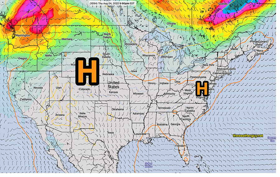
The rest of the week, we’ll be under the increasing influence of upper level high pressure—
GEFS forecast for Thursday showing jet stream winds located north in Canada with the 576 (500-1000mb) “thickness”(orange) contour showing the outline of the hot air mass extending eastward. Notice this contour encompasses most of the country! It will be extending well into Maine and into Montana and Dakotas. (Click on image for a larger view.)
At the same time as the hot air is moving towards us, a series of weak fronts associated with low pressure systems in Canada will affect our weather, especially late Thursday and Friday. More about that later in the week.