
Interesting Weather for Monday
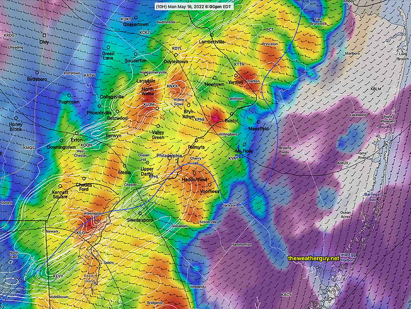
As mentioned the HRRR, HIRESW and the NAM-NEST did very well with timing and the handling of the front. The RAP was less impressive. Here are a few takeaways for the lack of severity—
•Temperatures were in the 70s, not the 80s or 90s
•Shear values were in the regular range one sees before thunderstorms. They weren’t over 30.
•Helicity values were relatively low. My software settings don’t even show helicity contours until they reach 400+.
•Shear and storm motion vectors were not aligned.
•Barometric pressure tendencies were flat before the frontal passage
• Jet streak position was west of the front and PHL was not in the entrance or exit regions to enhance the storms.
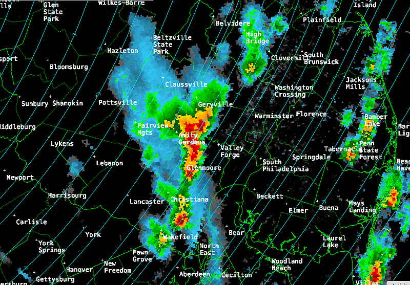
Update Mon @ 5:46 PM — Well, some severe strong activity has popped in upper Montgomery County. The NAM-NEST looks to be correct, as did the earlier HRRR. Expect some strong storms about 6-7PM
Update Mon @ 4:57 PM — The latest HRRR model has really backed off on the extent of [severe] storms coming. I can understand how it’s difficult for TV weather and the NWS to back off on a [hyped] forecast, especially when people’s safety might be at risk.
Nor did I want to stick my neck out too far with my post earlier today with a forecast saying these are going to be just the usual thunderstorms. But with my commentary on the overuse of word ‘severe’, it was my way of hinting at the possibility.
Anyhow, the latest NAM-NEST is still predicting a significant line of storms about 6-7PM . The latest HRRR not so much.
Any barometer fans out there? Maybe you’ve noticed the barometric pressure is already rising flattened? The front has already close to moving through!
Update Mon @ 3:01 PM — Newest models have the front moving through earlier- 4-5:30 PM (RAP Model) 5-7 PM (HRRR model)
Greatest shear is in northern NJ, not in this area.
CAPE is in the 1500-2200 range which is reasonably high. Latest HRRR has helicity in the 100-160 range in some areas.
There are differences in the two short range models. The RAP has several areas of storms moving through this afternoon into this evening The latest HRRR has storms ahead of the front with the main storm line moving through 5:30-7:30 PM (Philadelphia).
Updated Severity Parameter Table: (17z = 1 PM EDT)
| Last September‘s Tornadoes | Today’s Weather HRRR 06z | Today’s HRRR 12z | Today’s HRRR 17z | Today’s RAP 17z |
| CAPE 3500-4200 Joules/kg | CAPE 1500-2400 Joules/kg | 2000 | 1500-2000 | 2200 |
| Helicity 800-1100* | Helicity 150-250* | 100 | 100-160 | 130 |
| Vertical Shear 35-45 | Vertical Shear 15-25 | 10-15 | 25-30 | 15-20 |
| Precipitable Water 2.0″ | Precipitable Water 1.6″ | 1.5″ | 1.6″ | 1.6″ |
| Lifted Index 7-9 (minus) | Lifted index (minus) 6-7 | minus 6-7 | minus 6-7 | minus 6-7 |
| Peak Wind Gusts 40-50 | Peak Wind Gusts 35 | 35 mph | 35 mph | 25-30 |
Plenty of ingredients available for strong storms. However, shear vectors and storm motion vectors not aligned, suggesting difficulty in creating/maintaining severe storm cells. I guess we’ll see.
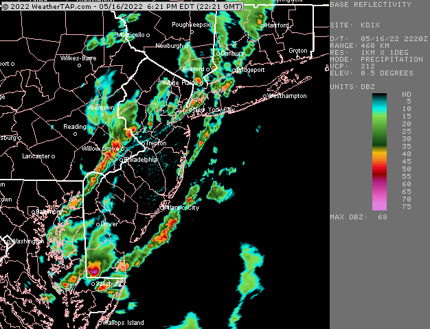
Update Mon @ 11:57 AM — Some storms have broken out ahead of the main front, as mentioned previously.
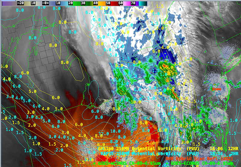
Of interest is the current water vapor image with superimposed NAM and GFS potential vorticity. There’s poor line up of these features, suggesting that these current models aren’t capturing reality that well.
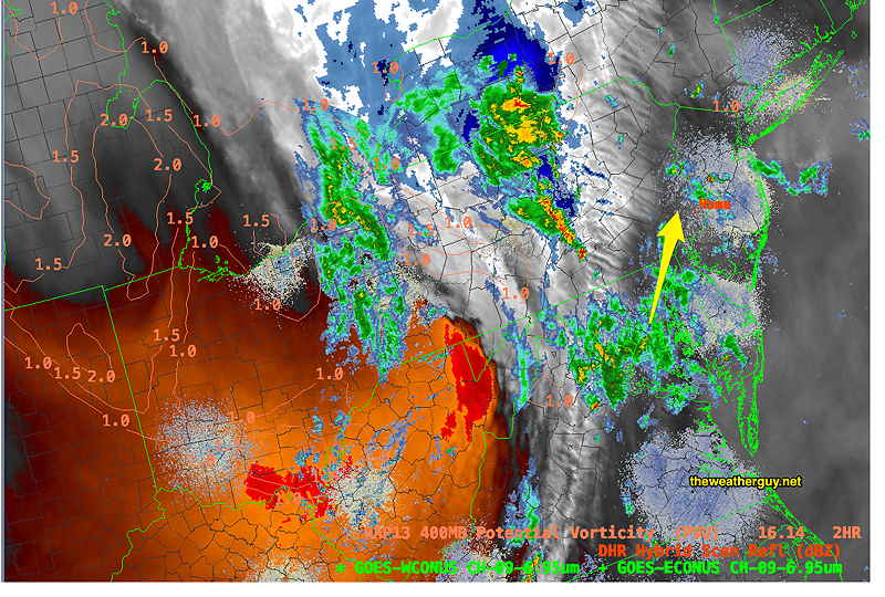
The RAP model has a better conformity to current water vapor imagery. The RAP has significant showers/thunderstorms during the afternoon, breaking out ahead of the main front that moves through at 6 PM—
This morning’s HRRR and HIRESW show the main area of thunderstorms moving through between 4-6 PM. Here’s the 12z HRRR at 6 PM—
I’ve also updated the table below with the latest HRRR representative values. Notice that the severe parameters have decreased, especially shear values.
| Last September‘s Tornadoes | Today’s Weather HRRR 06z | Today’s HRRR 12z |
| CAPE 3500-4200 Joules/kg | CAPE 1500-2400 Joules/kg | 2000 |
| Helicity 800-1100* | Helicity 150-250* | 100 |
| Vertical Shear 35-45 | Vertical Shear 15-25 | 10-15 |
| Precipitable Water 2.0″ | Precipitable Water 1.6″ | 1.5″ |
| Lifted Index 7-9 (minus) | Lifted index 6-7 (minus) | 6-7 |
| Peak Wind Gusts 40-50 | Peak Wind Gusts 35 | 35 mph |
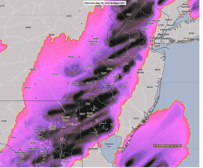
One parameter that stands out today is the hail parameter, unique to the HRRR model. It’s a parameter that can’t be always taken literally, but today’s hail parameters show the possibility of large size hail—
Update Mon @ 8:37 AM — Just a few thoughts about today’s weather. Can anyone remember an outbreak of thunderstorms where the term ‘severe’ wasn’t used?
From a liability point of view, I think the NWS and TV weather people use the term just a bit too frequently. (But who’s not going to say when there’s any lightning and wind involved that somewhere, it might be severe?) I think you get my point. Let me be more specific regarding today’s forecast.
I see a high probability of strong storms and maybe even ‘severe’ weather today. But let’s compare a few severity parameters to those from the relatively recent tornadic outbreak of this past September 1st.
| Last September‘s Tornadoes | Today’s Weather |
| CAPE 3500-4200 Joules/kg | CAPE 1500-2400 Joules/kg |
| Helicity 800-1100* | Helicity 150-250* |
| Vertical Shear 35-45 | Vertical Shear 15-25 |
| Precipitable Water 2.0″ | Precipitable Water 1.6″ |
| Lifted Index 7-9 (minus) | Lifted index 6-7 (minus) |
| Peak Wind Gusts 40-50 | Peak Wind Gusts 35 |
As you can see, there’s ‘severe’ and then there’s SEVERE of last September. Today will be different.
It’s sorta like the radio world where all children are ‘above average’ and all thunderstorms are severe.
I’m sure there’s going to be some big storms today. But I think it’s important to keep it all in perspective. While anything is possible with thunderstorms, based on today’s current forecast parameters, I don’t think there will be any tornadoes. This will likely just the first of many summertime ‘severe’ thunderstorm days. I’m glad I got this off my chest. 🙂
Updated Mon 7:36 AM —Unstable air and a cold front will combine to form strong thunderstorms today, Monday.
Additionally, low pressure systems are expected to form ahead and along the front, enhancing the duration of the rain. While the main front is expected to pass through about 5:30 – 6:00 PM, low pressure will develop causing thunderstorms to break out as early as 1-2 PM; additional rain may last until 8 PM. (This event will not be a single thin line of storms, based on current models.)
The morning high resolution shorter range models 24 hour forecasts will available shortly after 10:30 AM. I’ll update this post later this morning.
Your 8:37am update today was a wonderfully informative, fact-based explanation of how to understand “severe” thunderstorms. This is your site and we are all enjoying your hobby so of course however you want to run it, but I for one would love to see that chart be a regular part of your thunderstorm discussions. I have been reading your blog for a long time and know you have mentioned the factors individually before, but having them set out in a table drives home the point. I loved it!
Hi Brian, Thanks for the positive feedback. Yes, I had thought of doing the table thing for awhile. Today was the day! I will certainly consider doing this for future posts. I’m glad it clarified how today’s parameters compare to a past severe event. Thanks again for being one of my regulars here! Always good to hear feedback.
Thank you for always giving such detail in your forecasts! You break everything down where it is so easy to understand. I am a regular on your site and look forward to your posts. Thanks again!
Fran, I’m so glad find my postings valuable! Thanks for the feedback!
Thanks, as always for the extreme well-done forecasts and helpful insights!
Many school districts had early dismissals today due to the storm forecast. From a meteorological perspective, should we expect to take precautions like this going forward due to the real effects of climate change or is there a cultural response based on a whole lot of human factors (fear, anxiety, social media outrage, etc)? Sounding like an old man here, but “in my day”, they never dismissed early for thunderstorms. I know we’re in the shadow of the extreme storms back in September. Thanks again.
Thanks for that comment. I had no idea that the schools had closed early today due to the threat of “severe thunderstorms”. Incredible. I had no idea! I don’t know when that ever happened when I was a kid either. Then again, there are things daily on the news that routinely leave me speechless. Anyhow, I think the affront to your sensibilities that schools would do this over a clearly over-hyped forecast is very understandable. Wish I had something to add, but like the weather, these societal trends are bigger than any of us.