
#Philadelphia #weather #PAwx
Rain Update
Posted Friday 07/12/24 @ 3:40 PM —
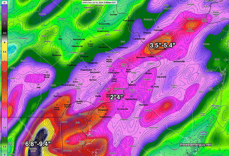
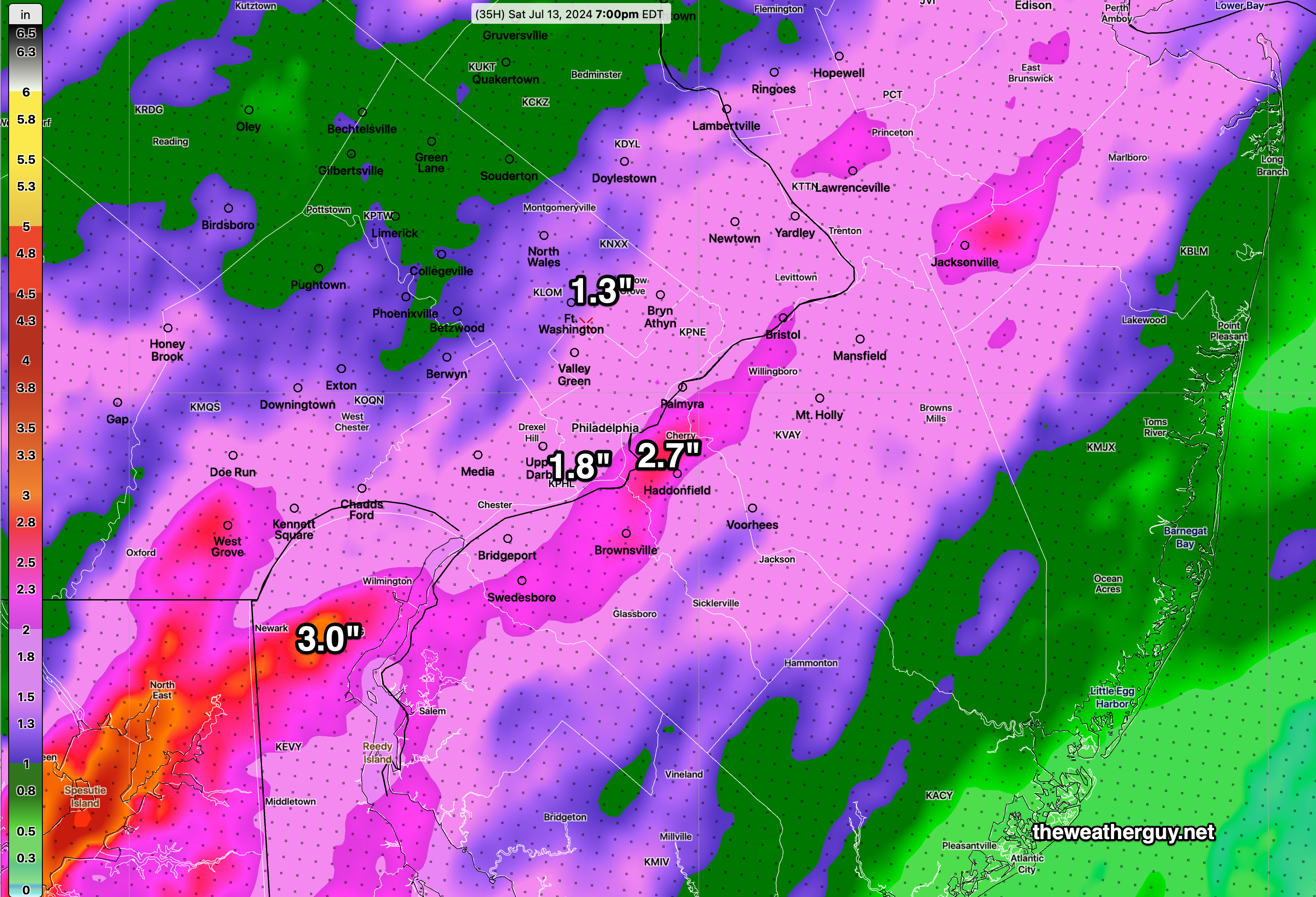
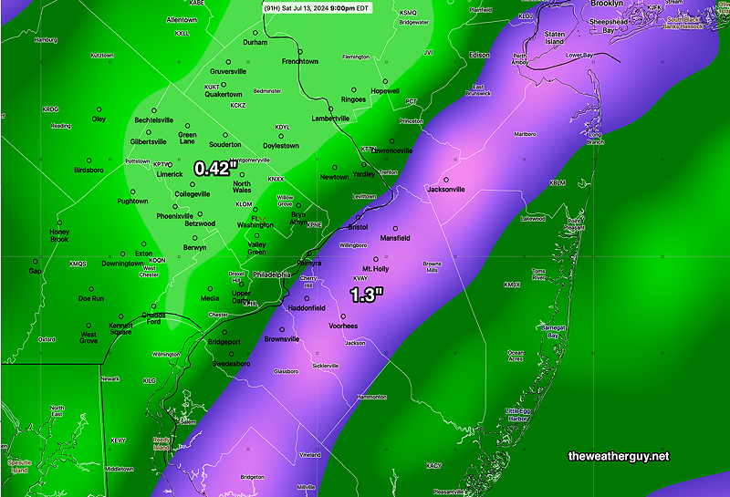
So where’s the heavy rain? Not where forecast. So far, the heaviest band set up over eastern NJ—
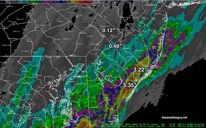
The 2 PM (18z) HRRR still shows areas of heavier rain to fall closer to the city over the next 24 hours, by 2 PM Saturday—
We’ll see if it happens!
Posted Friday 07/12/24 @ 11:40 AM —
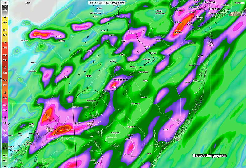
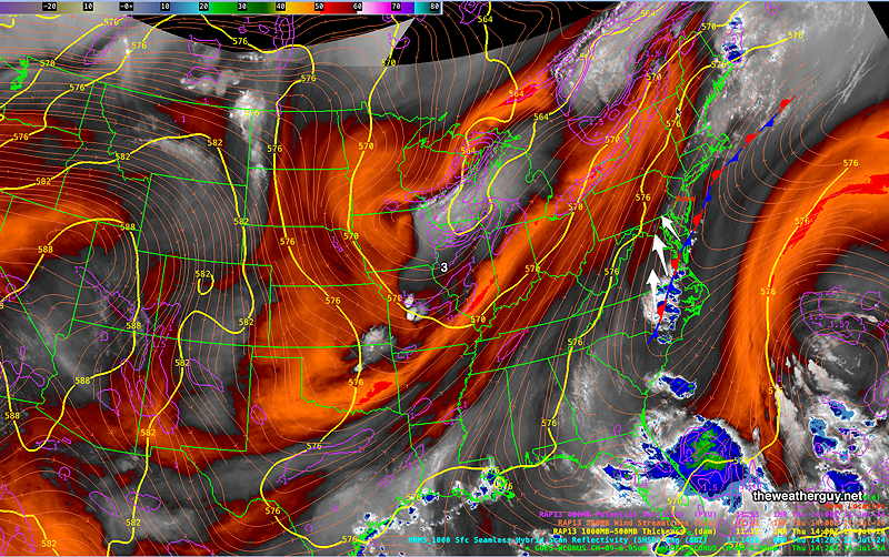
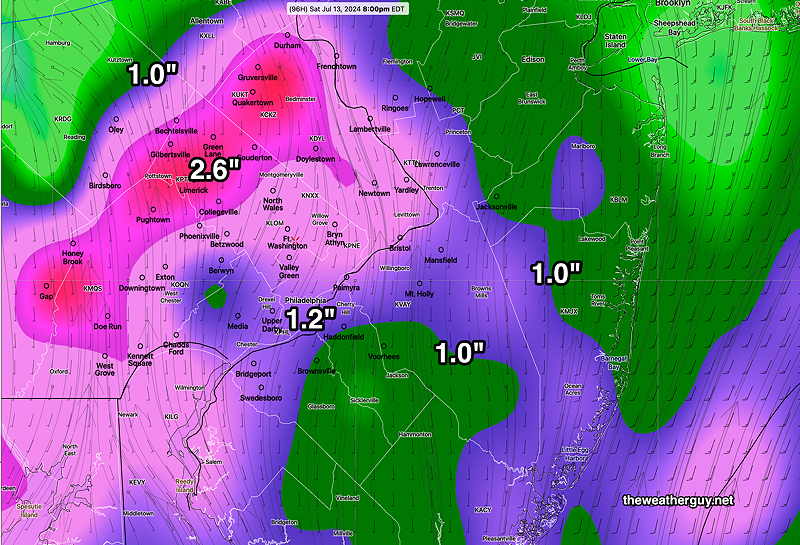
The latest HREF model (along with the experimental REFS model) are predicting truly unbelievable rainfall totals over the next 24-30 hours. I’m not sure that I buy it. Probably overdone. The latest HRRR shows rainfall totals in the 1.5″=3.5″ range and is likely more accurate.
Here’s the very latest HREF—
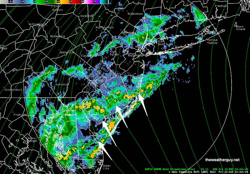
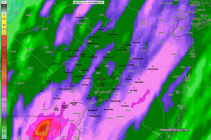
Posted Friday 07/12/24 @ 8:58 AM — The first round of showers has moved up over us and it was the first of many rounds of showers and even some thunderstorms that will move through from the southeast for the next 30+ hours.
The models are still forecasting 1-2 inches of rainfall with locally higher amounts through late morning Saturday.
Clouds may break for sun here in Philadelphia and westward on Saturday, but showers and clouds may linger at the Jersey shore into late afternoon Saturday.
Showers and Thunderstorms move in Friday Morning
Posted Thursday 07/11/24 @ 9:14 PM — The stalled front off of the coast will retrograde westward as a warm front Friday through Saturday.
High moisture flow will fuel showers and thunderstorms, beginning early Friday morning and lasting into Saturday morning. There’s some indication that considerable clouds and spotty showers may linger into Saturday afternoon, especially east of the city and along the NJ coast.
Rainfall totals will be over 1″ in many areas, with some areas receiving much more.
I’ll try to nail down the details with a Friday morning update.
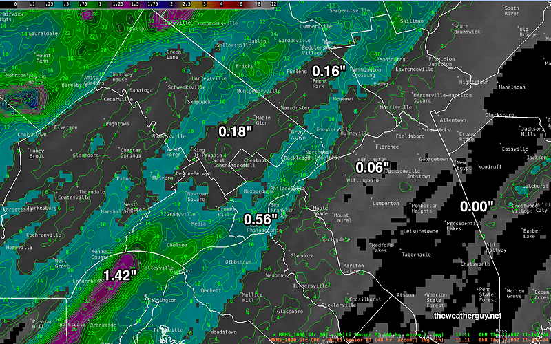
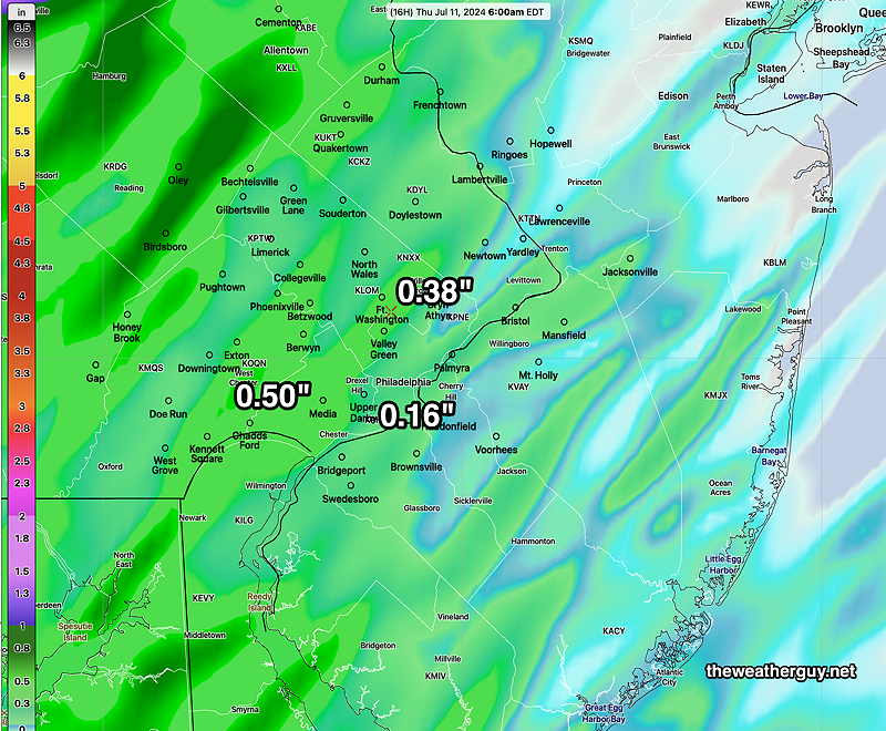
Here’s the rainfall totals from last night and compare here —
Hot and less humid today. Showers and thunderstorms arrive Friday morning as a stalled front retrogrades westward as a warm front. Showers linger into Saturday morning and Saturday looks to be unsettled with a spotty shower possible through the daytime hours, especially at the shore. Sunday looks to be hot again, perhaps with isolated pop-up thunderstorms
Much Needed Rainfall
Posted Wednesday 07/10/24 @ 4:55 PM — The first period of some much needed rainfall will be this evening, as early as 10 PM in western suburbs and continuing into Philadelphia by midnight. All models have the rain diminishing in intensity as it moves into Philadelphia and then NJ.
This first batch of rain won’t be all that heavy; many areas will receive only 0.10-0.50 inches with a few locally higher amounts in western suburbs.
For Thursday, mostly sunny, through high cirrus clouds. Highs upper 80s just short of 90º
Friday looks unsettled. Clouds and scattered showers moving in from the southeast during the morning. Heavier rainfall at night. Highs in the low to mid 80s.
The rain may linger early Saturday morning, but sunshine by afternoon.
Heavy Rainfall Looking More Certain
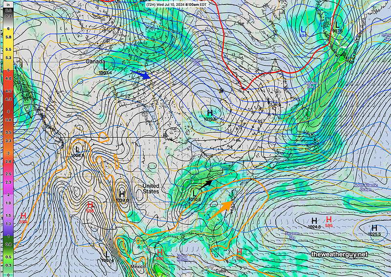
Posted Wednesday 07/10/24 @ 8:19 AM — I’m glad I waited the extra 12 hours for forecast clarification. The major models have all moved towards heavier rainfall in the Delaware Valley with the usual significant differences.
Tonight: The initial front moves through about 2 AM Thursday morning with a line of showers and thunderstorms. The front stalls close to the Philadelphia area. The exact location will determine the axis of the heavy rainfall. It appears that the front will linger until Saturday morning with on again, off again showers. Some will be heavy, especially later Friday.
Here’s the latest GFS model—
Here’s the current ECMWF—
So there are unknowns with this forecast: the exact position of the stalled front with the exact axis of heavy rainfall and the exact timing of the heavier bands of rain.
More Humidity and Maybe Some Rain
Posted Tuesday 07/09/24 @ 7:50 PM —
A stalled frontal boundary is expected to be a focal point for some much-needed rainfall late Friday. Unfortunately, there’s a trend with this afternoon’s models for the heaviest rainfall to fall in a narrow band, possibly to our south and east. There’s also some considerable model differences with several showing surface low pressure developing in the southeastern US, while the GFS and ECMWF don’t show this low pressure development.
Too early to say what will happen. I’ll update tomorrow morning with some graphics.
Posted Monday 07/08/24 @ 5:48 PM —The trend for the Tuesday and especially Wednesday is a significant increase in humidity and discomfort, with high temperatures remaining in the 93º-95º range. With the increase in humidity (dew points in the 70s) there will be an increased chance of isolated thunderstorms .
Many areas in our area need rain and the excessive heat is parching lawns and desiccating trees and other flora. Rainfall potential towards the end of the week is increasing and, with the exception of the latest GFS model, the ECMWF, Canadian Global and Germain ICON models are showing rainfall to be exceeding 1 inch in the Delaware Valley by Saturday morning.
The increased potential for rainfall Thursday, Friday and very early Saturday morning is the result of a stalled frontal boundary and a southeasterly moist flow off of the Atlantic. (The moisture from Beryl will likely move past us to our north.) The wettest day, if it plays out, will be Friday—
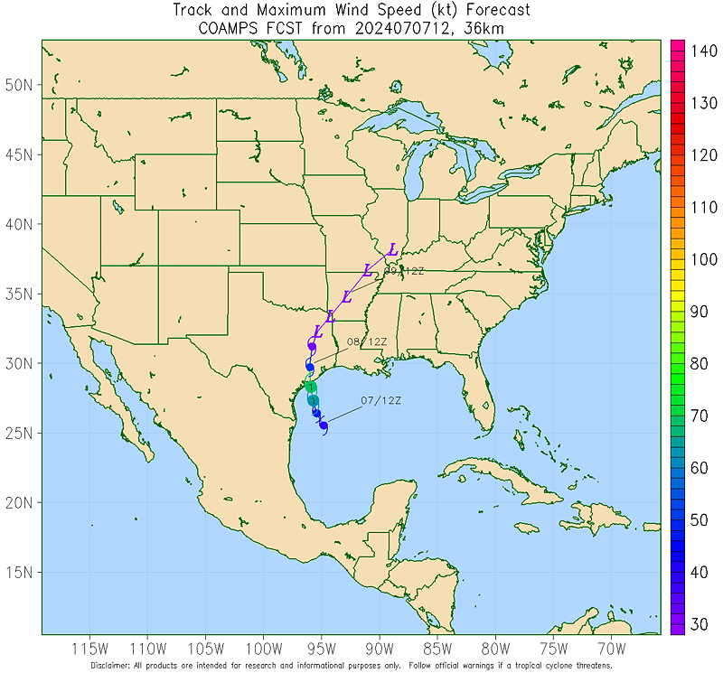
Previously Posted Sun 6:12 PM —A southwesterly flow of very hot air will remain in place through at least Wednesday. Thursday and Friday, the remains of Beryl with interact with a stalled frontal boundary in our area. The exact situation may be too complex to model in advance, so we’ll have to wait and see.
The US Navy’s COAMPS model’s track of Beryl—
Some much needed rain may be in store for Thursday through Friday, but current forecasts aren’t predicting all that much in the Philadelphia area. We’ll have to wait and see the position of the stalled front and the trajectory of the tropical moisture from Beryl.
For tomorrow, Monday, and Tuesday, continued hot, with temperatures in the mid to even upper 90s.
The NAEFS keeps us in the 90s through early next week!