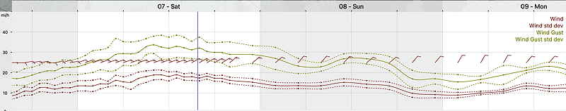
Update Fri @ 10:24 AM — A big feature of this system will be the windy conditions. Sustained winds near 20 mph with gusts in the 35+ mph range for much of Saturday.
Friday’s 12zNBM Wind Meteogram for Blue Bell, Pennsylvania (Click on image for a larger view.)
Update Fri @ 7:50 AM — The rain is moving in now from the west, on schedule. The latest GFS continues with the forecast for the heaviest rain to fall today, Friday through Friday night and into early Saturday. Then light rain to intermittent rain through early Sunday morning.
Total rainfall will be 2-2.5 inches with locally higher amounts. About 2 inches will fall during this earlier period.
Update Thu @ 10:46 PM — Tonight’s NBM, GEFS and NAM are showing the rain ending by Sunday late morning. Most show cloudiness lingering through the afternoon, especially areas south and east.
Update Thu @ 7:44 PM — 2-3 inches of rain expected Friday through early Sunday afternoon, with the greatest accumulations late Friday into early Saturday morning, according to the latest GFS.
Update Thu @ 5:53 PM — Rain is expected to move in from the west mid morning Friday (about 9 AM ± 2 hours). The ECMWF has rain starting as early as 6 AM and the Canadian GEM about noon.
Rain continues through Sunday morning. The models are coming together with clouds lingering but rain tapering and ending Sunday around noon or so. Some rain may re-develop Sunday evening.
I’ll have a better handle on this forecast tomorrow with my regular Weekend Weather Forecast.
Update Thu @ 9:36 AM — A quick update. The latest ECMWF just available continues the rain into Sunday early afternoon, especially south and east of Philadelphia. (The GFS has the rain ending early Sunday morning.) So there’s uncertainty whether Sunday will be a nicer day.
Latest ECMWF model just available shows rain lingering into much of Sunday, especially south and east. (Click on image for a larger view.)
Update Thu @ 9:04 AM — The expectation for clouds and rain for Friday and Saturday is still in the forecast. An upper level trough will slowly move eastward. Surface low pressure just to our south will bring an easterly flow of chilly air off of the ocean and rain. The rain looks to start as early as 7-9 AM Friday.
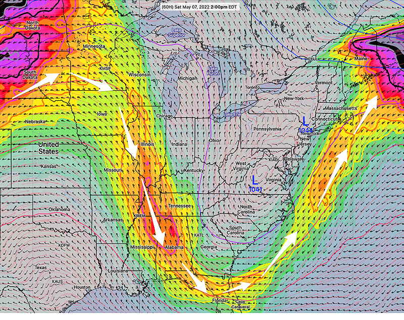
GFS Upper air wind (jet stream level 250 mb) forecast for Saturday at 2 PM. Deep trough over the eastern US with upper lows centers will spawn surface low pressure systems to our immediate south. (Click on image for a larger view.)
It still looks like we’ll have clearing on Sunday
Update Tue @ 8:30 PM — Not much change since yesterday’s posting. Very light precipitation amounts for Wednesday expected: 0.10-0.25 inches of rain, mostly coming in the morning hours .
The European and German models are predicting considerable rain for Friday through Saturday, on the order of 2″ of rain. The upper low looks to be just slow moving rather than quasi-stationary. As a result, Sunday should be dry with decreasing cloud cover.
It’s been announced that the NWS-NOAA will be upgrading their “Weather and Climate Operational Supercomputer System” referred to as “WCOSS” in a major way on or about June 27th.
This system does the actual data ingestion and weather model computations.
New Cray Supercomputers will almost triple processing power from 16 petaflops to 40 petaflops. This may result in weather models being available faster and in the case of evening models, earlier. It’s a giant upgrade and hopefully the transition goes smoothly.
(They are asking for forecasters to be alert for any systemic weather model errors.)
This week will feature a typical springtime weather pattern with plenty of showers and a quasi-stationary upper closed low in the forecast for the Philadelphia area.
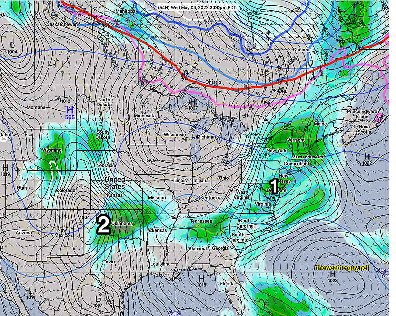
The first low pressure system will move in for Wednesday—
GEFS ” statistical mode” forecast for Wednesday showing low pressure (1) directly over us with rain/showers. A second low pressure system (2) takes shape in northern Texas, expected to move in Friday through Saturday. (Click on image for a larger view.)
The second system moves in for Friday through Saturday, as a closed upper low becomes quasi-stationary just to our south.
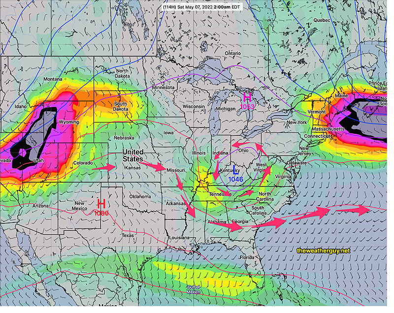
Jet stream (250 mb winds) for late Friday/Saturday morning—
GEFS mode forecast 250 mb (jet stream level) winds showing closed low over Kentucky for Saturday 2AM. (Click on image for a larger view.)
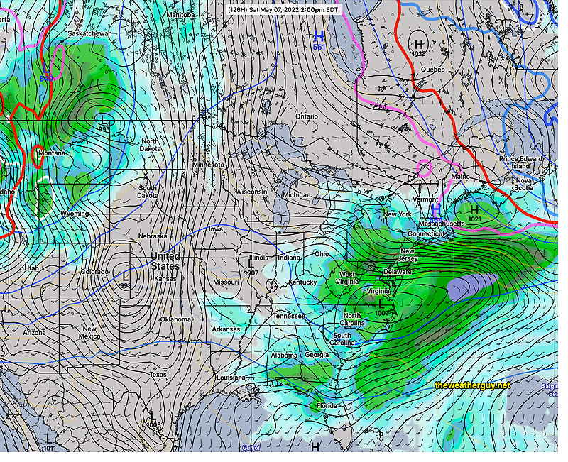
An easterly flow make it chillier with this system. As is often the case with closed lows, the exact position of the upper low (likely to change by Saturday) will make all the difference. Right now, it looks like rain.
GEFS (statistical mode) forecast for Saturday at 2 PM. Upper low and surface low will combine for rain. Southerly track means chilly easterly wind off the ocean for us. (Click on image for a larger view.)
The inclement weather may linger into early Sunday with slow clearing.
The exact position of upper closed low forecasts are difficult to forecast and I expect things might change by the weekend.