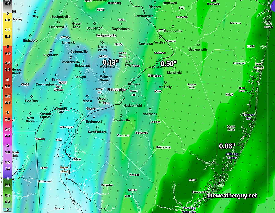
Update Fri 5/19 4:05 PM — This afternoon’s models suggest a heavier band of rain may develop directly over Philadelphia. That would be a significant change in the forecast of the past several days.
Previously Posted Fri 9:45 AM —
A coastal system will brush the Philadelphia area with light showers as it moves northeastward early Saturday morning.
A cold front approaches from the west during the day Saturday and moves through early Saturday evening with showers and possibly a few thundershowers. Most of the energy and rain will move up to our west missing us.
The models are in general agreement that the immediate PHL area and some areas to our immediate west likely will miss out in some much-needed rain—
HREF model forecast for total precipitation for Saturday. (Click on image for a larger view.)
Following the cold front, we’ll re-emerge into the same general pattern of a cooler and dry weather pattern—
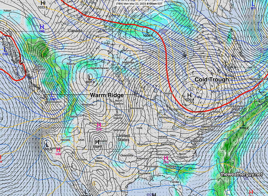
NAEFS forecast for Monday shows pretty much the same pattern we’ve been in: a cool trough pattern over the northeastern US and a warm ridge over the west.
Saturday
Clouds and showers in the morning, mainly from the city and east into NJ. Becoming sunny thought high cirrus clouds for much of the day. Clouds roll in later afternoon with some light showers in the evening. Many places from the city and immediately westward may not see any showers.
High temperature74.4º sd 2.9º ( NBM model location Blue Bell, PA)
Sunday
Sunny. Breezy
High temperature 77.7º sd 2.0º ( NBM model location Blue Bell, PA
Update Wed 05/17 @ 9:39 PM — The dry weather and somewhat cooler than average temperatures will continue through Friday.
Some showers are looking increasingly likely for Saturday, especially Saturday afternoon. There’s a wide range of forecasts regarding precipitation amounts.
It doesn’t look like we’ll get much rain and the spread in the models varies from 0.2″ to as much as 0.8″. I think we’ll see the lower end.
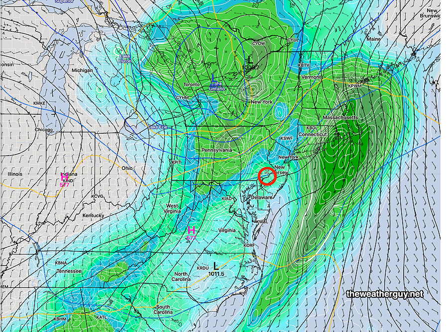
The current NAEFS, which is a blend of the GFS and Canadian Global, captures the scenario, with the heavier rain shearing off to our north and west and another area of heavier rain well to our east—
Today’s 18z NAEFS forecast for Saturday late afternoon. The heavier rain looks like it will miss us. (Click on image for a larger view.)
Update Tue 05/16 @ 8:16 PM — The dry weather continues…until Saturday. It doesn’t appear that we’ll get much rain on Saturday, possibly a few tens of an inch. Then more dry weather. Delightful, but the trees, flowers and grass are probably getting thirsty by now.
Update Mon 5/15 10:59 PM — Tuesday looks warm with high temperatures approaching 80°. Sunshine through high cirrus clouds. It looks like the showers Tuesday night will pass us by, even further to our south. Our dry weather continues.
Previously Posted Sun 9:14 PM —
An uneventful weather week is in store for us. Nice weather is expected Monday and most of Tuesday before a cold front moves through Tuesday evening.
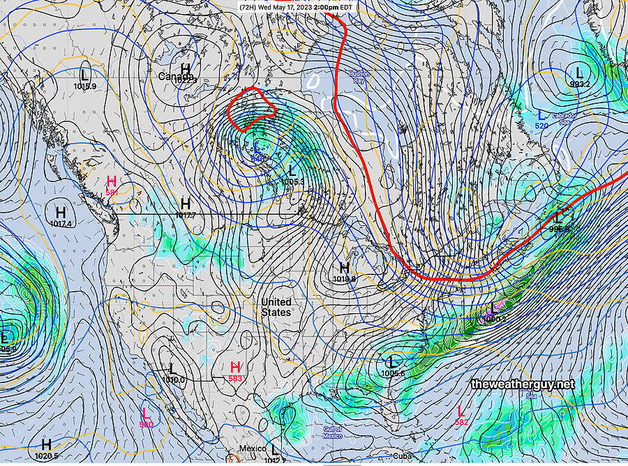
This afternoon’s 18z NAEFS forecast for Wednesday. The red line (540 thickness line) captures the general position of the air masses. with a cold dip in the jet stream to affect our weather Wednesday through Friday.
It’s been about two weeks since we’ve had any substantial rainfall, especially from the city northward.
We’re in a very dry weather pattern right now, with any precipitation moving just to our south. This was the case this past Saturday and it will likely be the case this coming Tuesday evening. It was also the case last summer when the word ‘drought’ came back into the local lexicon. Hopefully, this dry pattern will be a temporary situation.
For late Tuesday, the Philadelphia area will again be the dividing line between some rain (0.15+”) to the south and almost zero rain in the northern suburbs. Heavier rain is forecast for southern parts of South Jersey and Delaware.
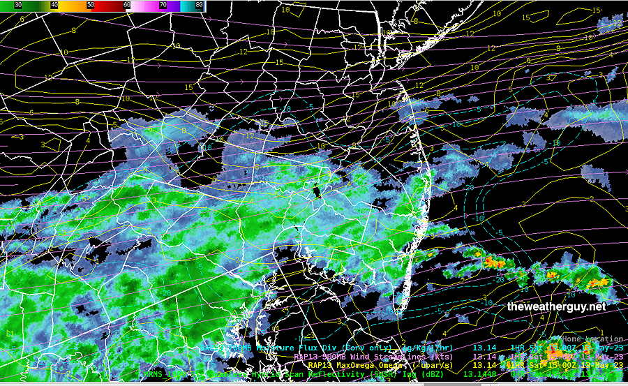
Update Sat 05/13 @ 10:58 AM — Here’s what we have at 11 AM
Current 11AM MRMS radar and RAP data. (Click on image for a larger view.)
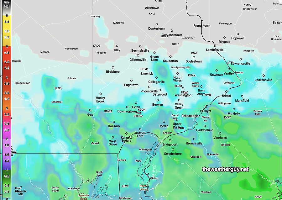
This is last night’s NBM (not previously posted)—
Last night’s 00z NBM (available at 9:30 PM EDT) showing the extent of the light showers. (Click on image for a larger view.)
Update Sat 5/13 8:12 AM — I knew my ‘dry’ forecast was a low confidence forecast. A few sprinkles have fallen this morning. Last night’s HRRR and Canadian maintain a dry forecast as shown in last night’s graphic.
Last night’s 00z NAM-NEST also showed a dry forecast, but its 06z run shows light sprinkles from the city southward, especially in the early afternoon.
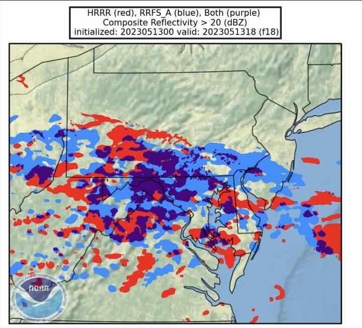
It should be noted that NOAA- NWS is working on a next generation model, called the RRFS (Rapid Refresh Forecast System), scheduled for release sometime this fall. It will actually replace several models: the NAM-NEST, HRRR, HIRESW-ARW (all three versions) .
While not ready yet for prime time, here’s its current forecast compared to the HRRR:
Pre-release beta version of the RRFS. It shows more more shower activity north of the city (blue) than the current HRRR (red) at 2 PM. (Click on image for larger view)
Anyhow, I’m going to backtrack on my ‘update’ from last night and removed the strike-out from the forecast posted below to its original form.
Saturday Forecast Update
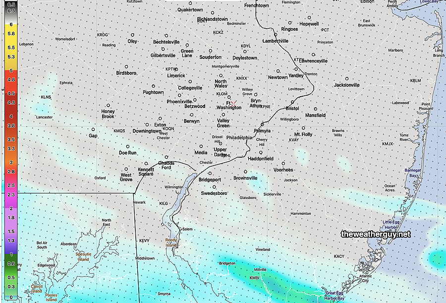
Update Fri 05/12 @ 9:58 PM — It hasn’t been even an hour since I posted this Weekend Weather Forecast, but I’m going to remove the mention of showers in the immediate PHL area for Saturday, based on the latest HRRR just becoming available and the consistent forecast of the Canadian models.
So I’m going to call for no rain here, despite the GFS, NBM and ensemble forecasts to the contrary.
Tonight’s 00z HRRR shows most of the immediate PHL area dry on Saturday. (Click on image for a larger view.)
Previously Posted Fri 9:23 PM —
A disturbance is expected to move to our south on Saturday with the rain shield staying in Maryland and southern Delaware. As has been the case over the past few days, some models keep the immediate PHL area dry.
However, at this point there are enough models, particularly the statical ensemble models, forecasting very lightscattered showers moving through Montgomery county and into New Jersey, that I need to include that possibility in Saturday’s forecast. I’m not all that sure about this aspect of the Saturday forecast because the Canadian models have consistently kept us dry.
Saturday
Cloudy with very light and scattered showers as early as 8 AM. Heaviest showers (if they occur here) early to mid afternoon.
High temperature 78.4º with a high uncertainty as expressed as a higher than normal standard deviation of 4.4° ( NBM model location Blue Bell, PA)
Sunday
Some cloudiness early morning, becoming sunny by late morning.
High temperature 72.5º sd 1.5º ( NBM model location Blue Bell, PA)