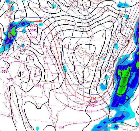
Despite the warm front that moves through Wednesday night and the warm and wet day expected Thursday, the models have a very deep upper air trough developing and moving through for Friday through at least the weekend. The surface weather map for Saturday looks like something you would expect to see in January.
Expect very cold weather for this weekend, despite very bright, sunny late March skies.
Lucky for us, the trough will be in a position that keeps any low pressure development off the coastline. At least, that’s what it looks like right now.
A few weeks ago, I gave a nod to the accuracy of Channel 6 weather forecasts and that Adam Joseph seems to know what he’s talking about without the hype. Now, if only Cecily Tynan could get rid of the word “tracking” in every other one of her sentences.
The National Weather Service is actually excellent with their forecasts, but unfortunately, the media often doesn’t fully communicate their forecast, or they reduce it in the newspaper to an image of a cloud or the sun. The Mt Holly NWS Twitter feed is very good and people should follow them.
On the other side of TV weather land is Kathy Orr and Kate Bilo of Channel 3 and KYW. It’ my opinion that their forecasts are off-target and superficial, resulting in communication inaccuracies. They seem to miss the forecast nuances and they seem to avoid the uncertainties. Last Thursday, they were still saying the snow would turn to rain in PHL on Friday afternoon. Their forecast high temperature was 39. That was not going to happen and that should have been clear by their Thursday evening forecast.
Yesterday, in the evening forecast, Kathy Orr mentioned temperatures in the 70s. What is she talking about???
Then there’s Glenn Schwartz on Channel 10. In my opinion, there’s too much Schadenfreude about bad weather. He knows his stuff, but the style gets in the way of the message. Why does he chuckle when describing coming bad weather?
And finally, it would be more credible to viewers, when a forecast is wrong, for these same forecasters to acknowledge the forecast error and explain why it happened. It would increase their credibility. Something to consider.