Philly Weekend Weather Forecast

Perhaps no one noticed, but the models did very poorly with today’s (Friday ‘s) forecast.  There was supposed to have been heavy rain followed by sun in the afternoon. Neither occurred. Let’s see if the weekend forecast is more accurate.

A frontal boundary draped near the Great Lakes won’t move until Monday.  (At least that’s what the models show.) High pressure builds in Saturday.  Mostly sunny skies with high temperatures near 55.

Late Saturday,  high pressure retreats to the northeast and an easterly flow of moisture develops causing low cloudiness.  Mostly cloudy skies expected for Sunday with high temp again near 55.

Saturday Update:  I want to mention that the long range models have been consistently showing an outbreak of deep cold air for next weekend, the beginning of April.  Winter has at least one more guest appearance.

Sunday Weather Update

The latest NAM model data becoming available at this time.  (When in Eastern Standard Time, some data is available as early as 9:10, but with Daylight Savings Time, all models are available an hour later local time.).

The latest NAM data shows snow for our area, but again with a fast cut off north and west of PHL.  Latest QPF values are in line with last night’s GFS- about 0.21 inches water, mostly falling during the evening hours.   1-2 inches in PHL possible, mostly on grassy surfaces, more in areas of NJ.  Snow starts late this afternoon here in PHL and goes through a little after midnight. (Much earlier in Delaware where they may have a more significant accumulation. )

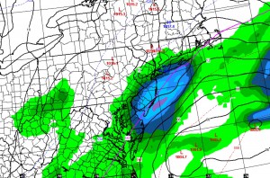
Here’s the NAM forecast map for the 3 hour period prior to 10 PM tonight

NAM Forecast for the three hour period prior to 10PM tonight

Notice how the bullseye for the snow is just east of PHL.  Small variations can again blow this forecast.

1PM Update-  This morning’s GFS has the precipitation further east and barely reaches PHL. So this could be another zero.

8PM Update- There is some snow falling, but surface temperatures in the region  just seem too warm for any accumulation.  .

Big Forecast Changes (Again)

So, the models didn’t get it right today and the forecasts were off (including my own), but a postmortem shows the NAM probably did the best in retrospect regarding the precipitation being suppressed to our south.

But here we go again- the NAM is showing a second impulse to develop and intensify off the coast Sunday afternoon and evening.  QPF values over 0.32 inches water.

This time, temperatures will be cold enough for accumulation and the bulk will occur after dark Sunday evening.  This afternoon’s GFS was suggesting this as well (but I had discounted it because of how poorly it modeled today’s weather.)

Like today, a 25 mile error in the extent of the precipitation shield will make or break this forecast.  But if it verifies, we could wake up to 1-3 inches of snow Monday morning, mostly on grassy surfaces .  Of course, it will all be gone quickly.

Sunday 8AM:  Last night’s models continue with the likelihood of snow later this afternoon and the first half of Sunday night.  Differences exist between the GFS and NAM, with the latest NAM showing a period of heavy snow this evening.  Not ready to go with that scenario, but an accumulation of 1-3 inches is possible by daybreak Monday morning, more if the NAM continues its trend.

Of course, things didn’t play out yesterday, so can we trust the models today?

Weather… and Other Things 'Up in the Air'