Thur 08:49 PM Update— Tonight’s models suggest any wintry precipitation on Sunday will be well north of the Philadephia area and suburbs.
An active weather pattern with a series of systems and fronts will affect the Philadelphia area from New Years Eve through Sunday.
Tonight (New Years Eve), a cold front will continue slip to our south. Additional showers broke out this afternoon, but no rain is expected this evening.
Thu 05:35 PM Update —Falling temperatures tonight may result in some black ice on roadways later tonight.
On Friday, the same front will slowly move back as a warm front, as low pressure moves up through the Great Lakes. Rain will return between 12 noon and 3 PM Friday and there may be some mixed sleet and freezing rain in the northern and suburbs.
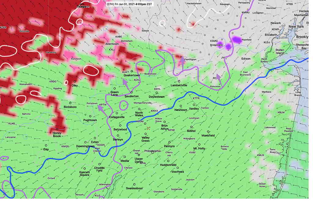
For Friday, freezing rain (red shading) is predicted by the NAM-NEST very far northwest, but it wouldn’t surprise me if it’s underestimating the wintry mix at the start and some sleet is falls closer to the city, north of the lavender line (upper level freezing) shown below—
NAM-NEST Precip type (red=freezing rain) and upper air critical temps Friday 4 PM (Click on image for a larger view.)
Eventually, there will be a changeover to all rain even north of the city as the warm passes through.
Saturday features clearing and some sun. It will be unseasonably mild, with highs in the low to mid 50s.
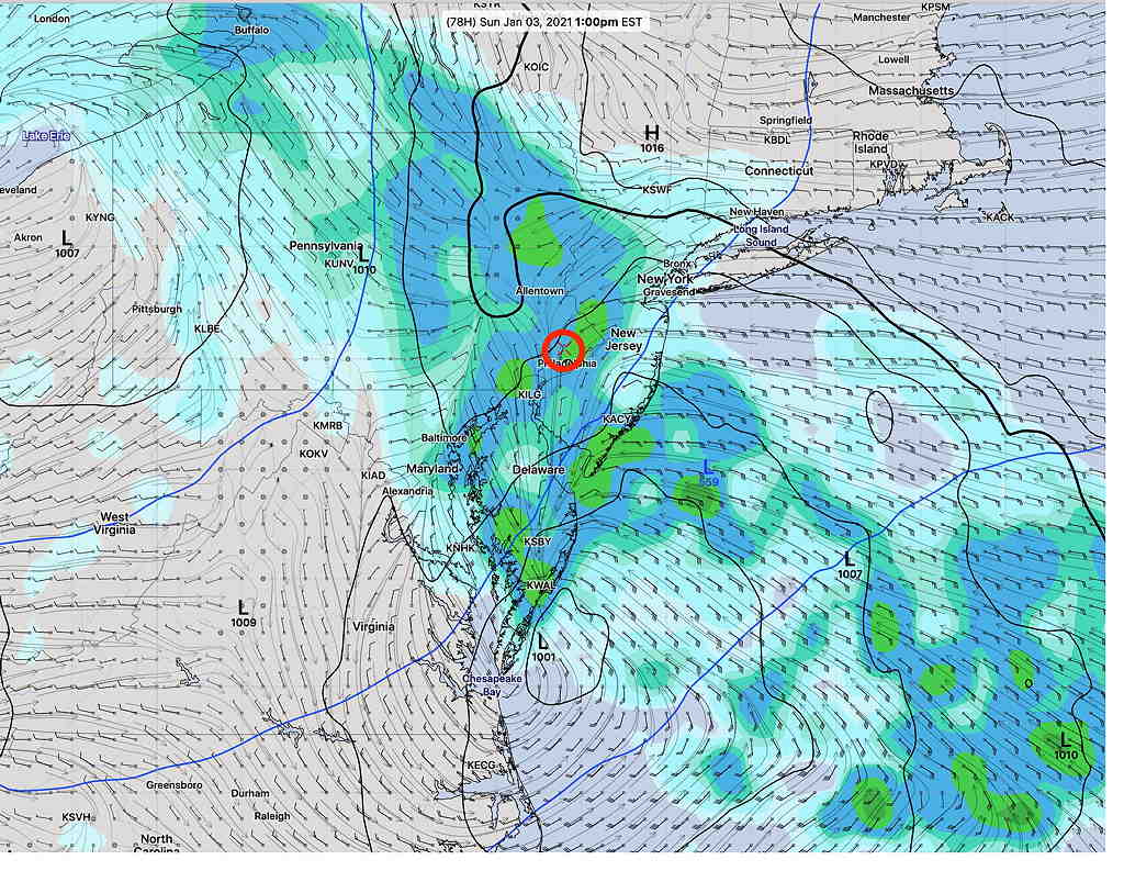
Things get interesting Sunday, as the low pressure system near the Great Lakes spawns a coastal low off of Virginia—
GFS version 16 surface precip forecast 1 PM Sunday (Click on image for a larger view.)
Most models (and the model blend) have rain for our area on Sunday, but the latest “parallel GFS version 16” has greater low pressure intensification and more cold air on the northwest flank of the storm.
As a result, the new GFS version 16 is showing some snow and accumulation for Sunday afternoon north and west—
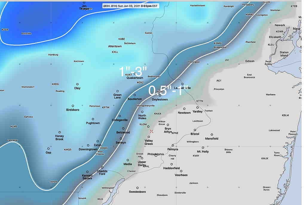
GFS snow depth forecast Sunday 3 PM (Click on image for a larger view.)
The latest NAM and NAM-NEST and GEFS also show some snow falling far northwest, although not as much as the GFS.
Based on comparing predicted temps with actual temps, the new GFS is running a little too cold today, which may explain the higher wintry precip forecast.
I guess we’ll see how good the new GFS model is. Stay tuned.
The weather for New Years Eve will dry, as a weak cold front is expected to move through with showers early Thursday morning and things dry out for New Years Eve.
However a warm front associated with a low pressure system in the Midwest brings in rain New Years Day (Friday) to start out 2021.
The general pattern this week is for our area to be under the influence of an upper ridge pattern and a mild moist flow from the southwest ahead of this low pressure system moving up to the west of us through the Great Lakes on Friday—
GFS (new version 16) forecast 2 PM Friday ; arrow represent upper flow (Click on image for a larger view.)
After the rain moves out Friday night, Saturday should turn out dry and mild with high temps in the low to mid 50s. I should mention that average temps are 41 º high, 25º low ( Blue Bell) this time of year.
Yet another system moving in Sunday brings more rain as a coastal system tries to develop off the coast. The upper air pattern does NOT favor development of a nor’easter or any snow from this system.
In fact, snow lovers right now will have to wait for a pattern change. As mentioned in several posts recently, my pattern assessment is “lack of very cold air” to our north.
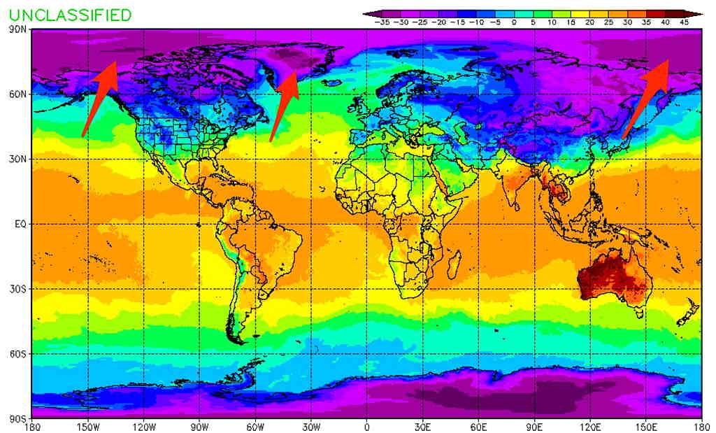
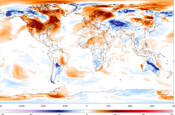
NAVGEM Surface Temperature Forecast Jan 8- Warmer than average in polar areas and most notable are the warmer temperatures over Greenland. (Click on image for a larger view.)Temperatures Departure from Average
The main model used in US weather forecasting is the GFS (Global Forecast System), a model that continues to be developed and improved. The last major upgrade to the GFS model occurred in June 2019 with the release of the GFS-FV3 which was “version 15” in its evolution.
I wrote a brief post about this model back then, describing the changes in “FV3” ( Finite-Volume Cubed Sphere Dynamical Core) geometry that the model uses to divide up the atmosphere into geometric units that can be handled mathematically. The complexity of these models is amazing and the NOAA scientists that create these models can only be admired.
The new version of the GFS model continues with the FV3 geometry (in the long line of this model evolution, this will be GFS version 16) and it has just become available this past week on a full time NOAA server. It’s available in what is referred to as a test “parallel mode”, meaning that it is running at the same time the current operational version (v 15) is running.
If you’re into technical stuff, or just want to be dazzled by the science of these models, check out this early presentation from the NOAA Model Evaluation Group. It gives a brief history of the GFS model development and also presents the improvements, short-comings and challenges of the new GFS v16 model. The official GFS v16 evaluation website can be found here with plenty of additional information.
If all goes according to plan, it should become the GFS model early February 2021.
I would expect general improvements in weather forecasts with its release. Additionally, the GFS model is used to set the boundaries and initial conditions for several other models—
So several other models’ accuracy will benefit when the GFS v16 becomes operational early 2021.
What could be a better example of the new GFS model’s improvement than today’s cloud forecast? Last night’s operational GFS had forecast for it to be sunny here at 3 PM today, keeping the clouds to our west —
Current GFS model showing clouds stay to our west at 3 PM (Click on image for a larger view.)
The new, soon to become operational GFS version 16, had a correct cloud forecast for today at 3PM—
New GFS (version 16) had the correct cloud forecast for this afternoon, showing clouds overspread much of the area. (Click on image for a larger view.)
Last night’s indecision about cloud cover for today would have been less of a dilemma had I used the new GFS.
One of the issues of the new GFS is that the new model’s data size is almost twice as large as the existing GFS. NOAA is concerned about the data download size issue and it is expected to limit data download rates within the month for all their models. We’ll see how that plays out.
Another minor issue— the higher complexity of the new GFS takes more computational time. As a result, the new model take 7-12 minutes longer to complete. As an example, the first 24 hours of the current GFS become available about 10:37 PM EST. With the new GFS model, the first 24 hour forecast data will become available about 10:46 PM EST.
Those 11 PM TV weather entertainers are going to have even less time to update their forecasts during Eastern Standard Time.
The new model is an overall improvement, but not without its problems. It tends to handle tropical systems not so well, sometimes developing systems that don’t actually form. Certain parameters used for forecasting thunderstorms are understated, especially when soil moisture is low. Forecast temperature biases, while improved, also have their issues. You can be sure that scientists are already hard at work with a future version 17.
One more thing— the HRRR and RAP models were updated earlier this month and have shown improved forecasting accuracy and an increase in model forecast length. The HRRR has become a full 48 hour model and the RAP a 51 hour model. These same models are expected to start using the same FV3 core geometry used by the GFS in their own next iterations.
Several other high resolution models (HIRESW and HIREF) have been upgraded to the FV3 core geometry and are planned for release in the next few months. Their output is now available as “parallel” models.