Outlook Updated Tue 5:58 PM — Current models do have the cold front pushing precipitation out of our area for Saturday. (There had been the possibility that the front would hang up right over us, keeping things cloudy and wet.) Sunday also looks good right now. Cooler, more seasonable temperatures for both Saturday and Sunday.
from Sunday….
As mentioned in my previous post, a transition in our area from a jet stream trough to a jet stream ridge (warmer weather) will occur during this week.
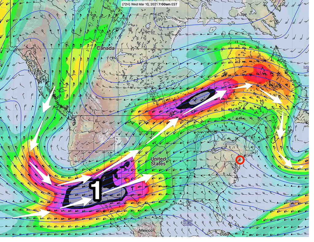
GEFS Model 300 mb wind forecast for Wednesday morning. The phasing of jet streaks (1) will cause a low pressure system to develop in the Midwest. The eventual track will affect next weekend’s weather. (Click on image for a larger view.)
This ridge will allow temperatures to reach into at least the 60s (and possibly near 70º) for the Philadelphia area by Wednesday.
The current Model Blend forecast high temps (Blue Bell -Wings Field, add about 1 to 2º for Philadelphia.)
Wednesday — 62º Thursday — 66º Friday — 66º
The uncertainty with these temps is high. The Model Blend standard deviation is 3º-5º. In these situations, the NBM can be on the low side.
For Next Weekend: Also uncertain is the eventual development and track of a deep low pressure system in center of the country from confluence of the southern and northern jet streams. We may enter a prolonged period of rain that goes into the weekend, OR we may have a cold front push far enough south to suppress the moisture to our south and give us a dry, cooler, and windy weekend.
Sat 05:56 PM Forecast Review — We had significant cloudiness today. Comparing the new GFS v16 forecast with actual observations of the RTMA (Real-Time Mesoscale Analysis) at several points during the morning , I would say the GFS over-stated the cloudiness a bit. The GFS barely predicted the snow flurries, but that’s partly because it is not a high resolution model. Also, the GFS also not a model that’s designed to do ‘convective type’ snow flurries well. The newly updated RAP and HRRR did well in predicting the flurries, but also somewhat over-predicted the cloudiness.
Forecast Updated Sat 9:25 AM — To be more specific, yesterday’s RAP (Rapid Refresh) model had predicted these snow flurries, but it had kept them north of the city. I had ignored them for the forecast; so often these are false positives.
RAP model from 5 PM Friday showing snow flurries (violet shading) north of the city. (Click on image for a larger view.)
Today’s RAP model from 7 AM Saturday predicts additional snow flurries about 3-4 PM today—
RAP 12Z model forecast for 3-4 PM snow flurries (violet shading). (Click on image for a larger view.) We’ll see if those are false positives.
We’ll see if the afternoon flurries are false positives.
Forecast Updated Sat 8:04 AM— Radar shows snow flurry activity to move through some areas this morning! Last night’s RAP model had these snow flurries, but I ignored it. The RAP also has some snow flurries possible this afternoon about 2 PM, especially north of the city.
Forecast From Friday…
The sun angle is higher and the sunshine brighter; Spring is clearly on the way.
However, a fairly sharp upper air trough pattern will settle in for the weekend bringing cold weather before the trough moves to the east and is replaced by an upper ridge by Wednesday, bringing warmer weather at that time.
Saturday Upper Trough brings cold weather
Wednesday's upper ridge brings above average temperatures
Saturday’s colder weather will also feature a strong area of upper level vorticity moving through. This upper vorticity (upper air disturbance) will be accompanied by moisture and many of the models show considerable cloudiness for Saturday.
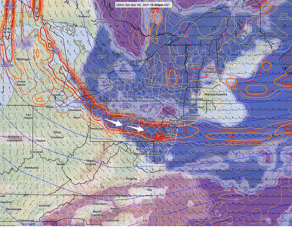
Here is the new, soon-to-be-released GFS version 16 (Release date scheduled for this March 17th) which shows considerable low cloudiness from mid morning to late afternoon Saturday—
GFS version 16 Absolute vorticity (red/orange lines/ovals) causing cloud cover Saturday 12 PM (Click on image for a larger view.)
This will be an interesting test for the new version of the GFS which has had its cloud parameters and physics updated. While most models show some degree of cloud cover during the day, some models (Canadian, NBM) only show 60-70% cloud cover, mostly in the afternoon, while the new GFS shows close to 100% cloudiness from 9 AM through late afternoon.
Along with the cloudiness, the vorticity will cause Saturday to be WINDY. Saturday’s high temp 37º ± 2.1º (NBM – Blue Bell)
Average high is 49º/51º (Blue Bell/Philadelphia)
For Sunday, the upper trough moves a bit more to our east and high pressure dominates. Mostly sunny skies Sunday, but with some fair weather clouds. Still breezy mid-day. High temp Sunday 39º ± 1.6º (NBM Blue Bell)
Following a cold front passage on Monday, temperatures will get colder than average for our area for most of the week and coming weekend.
A highly amplified jet flow will result from cold air dropping south from Canada and warm air pushing up the central US. We’ll be on the cold side of this seesaw at least through Friday.
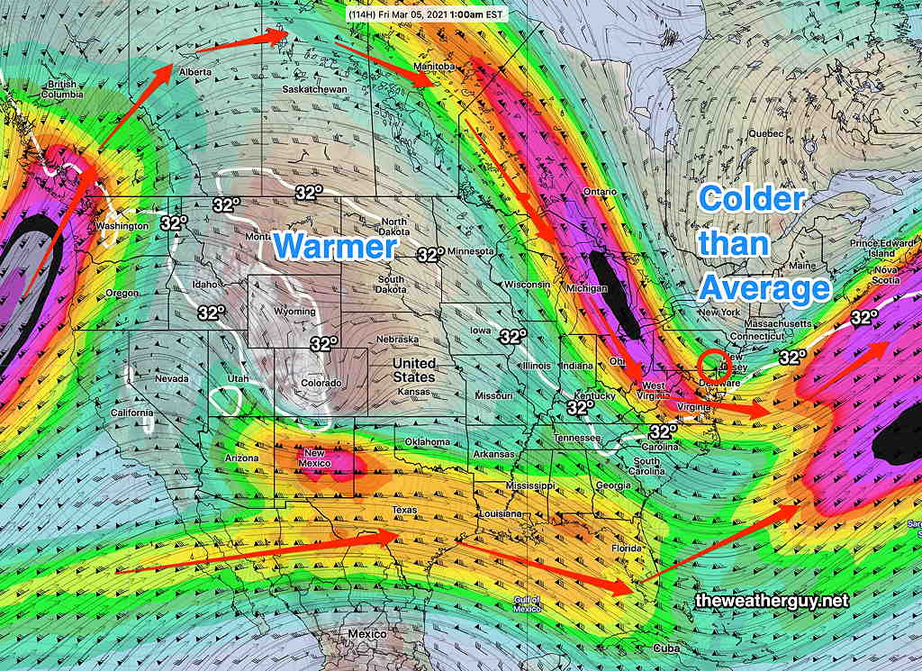
The statistical/ensemble version of the GFS, the GEFS (Global Ensemble Forecast System) shows the configuration of the northern jet flow as well as the configuration of the southern stream for Friday at 1AM —
GEFS jet wind flow at 300 mb 1 AM Friday Notice that any phasing between the two jet flow as well as any storm development occurs well east of the US, in the Atlantic. (Click on image for a larger view.)
Things will be cold for our area, but quiet storm-wise.
As a character on a popular TV comedy series might have put it “NO STORM FOR YOU.”
Things look even quieter next week.
Then again, the current predictions of the jet configuration is a major change in the model forecasts from just a day ago. Things could always change.