Category Archives: Winter Storm Outlook

ACTIVE WEATHER WEEK

Mon 05:46 PM Update — This is complex forecast.  Snow is NOT the issue. Precipitation type (sleet, freezing rain, rain)  is a question.

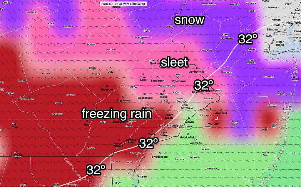
There are  differences between various models, especially regarding surface temperatures and temperatures below 6000 feet between 6 AM and 11 AM.  There are different forecasts for precipitation type. 

The NAM/NAM-NEST group have temperatures below 32º while the GFS/RAP group have it a above freezing.   So the NAM group has more freezing type precip (sleet/freezing rain) after daybreak.

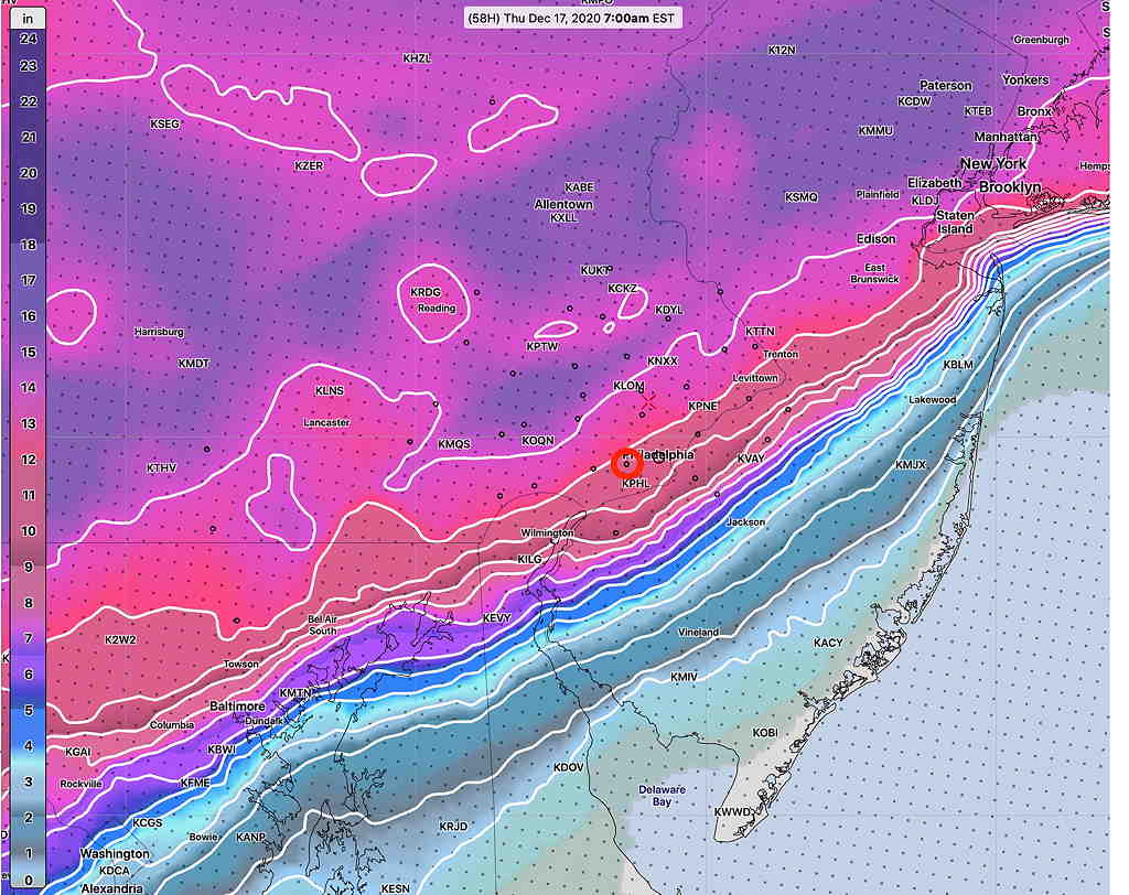
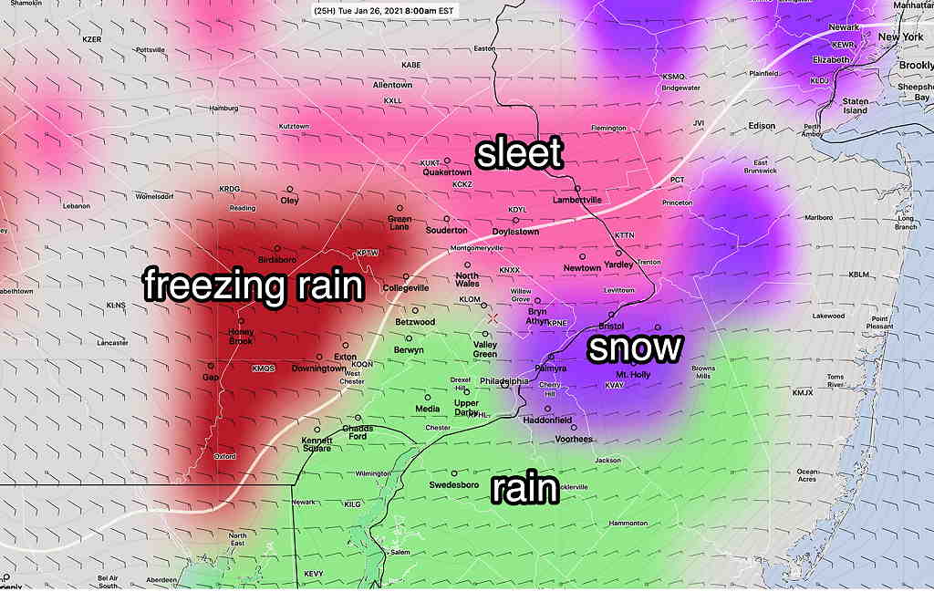
In the old days (before I  had direct model data), I would use the NAM FOUS data for my forecast.  The FOUS shows little snow for our area, but maintains a longer period of sleet/freezing rain/rain into the mid morning hours.  So, I’m leaning towards the NAM group for this forecast.  The graphic below captures the parameters of the NAM FOUS data—

NAM NEST PTYPE forecast with 32ºF isotherms 9 AM Tues  (Similar NAM FOUS)  (Click on image for a larger view.)


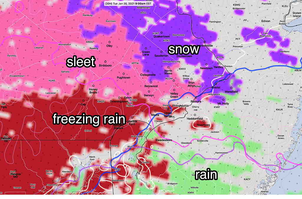
Both model groups have the majority of precip in the immediate PHL starting later,  after 8 AM, although it starts earlier far southwest of the city.

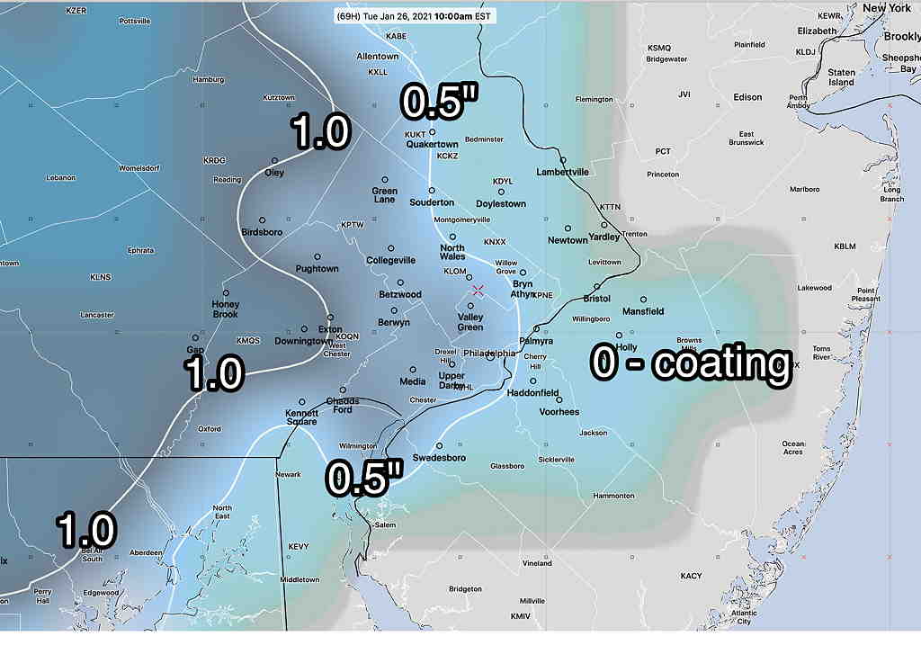
Areas southwest of the city will have precip start before daybreak; these  areas are more likely to get a coating of snow before the changeover.    

If things change, I’ll update between 10 and 11 this evening


Mon 01:35 PM Update — A quick update.  This morning’s GFS has virtually NO snow accumulation for the immediate PHL area.   Surface temperatures rise above freezing early, so most areas won’t see any freezing rain either.   Just light rain.
GFS model 8 AM Tuesday PTYPE (note that these areas become all rain quickly)  (Click on image for a larger view.)


Thursday’s expected storm will miss us entirely, according to the latest GFS.

Sun 10:46 PM Update — Tonight’s models suggest several hours of light sleet and freezing rain after daybreak Tuesday morning following a light coating of snow that falls before daybreak. It’s not clear if the models are over-predicting this freezing precipitation potential.  We’ll need to see tomorrow’s models to get a better idea of the thermal profile on Tuesday.


Sun 04:53 PM Update — Today’s models continue to downplay the snow for Tuesday.
NAM NEST snow totals Tuesday. Philadelphia has a coating

 Warm air moves in at 2000-3000  feet, resulting in a period of sleet and freezing rain instead of snow after daybreak Tuesday.  Little accumulation in and near the city. 


The storm for Thursday, while more developed, appears only to brush us with some snow.  Again, an inch is the most likely amount.

From Saturday evening…

The upcoming week looks to be a relatively active weather week compared to the past few weeks.

Tuesday—

The storm expected to pass to our south on on Tuesday is showing less development and less moisture. Additionally, it now appears to move in later Monday evening and gradually exits during the day Tuesday.

Warm air appears to be brought in about 2000-3000 feet above ground level.  The predominant precipitation type will be sleet/freezing rain, then light rain on Tuesday instead of snow, after a small accumulation Monday night.  Total accumulations have reduced to under 1 inch for most of the immediate Philadelphia area—

GFS snow totals 10 AM Tuesday  (Click on image for a larger view.)

It appears that light rain showers, may linger on and off into the day Tuesday, tamping down or melting some of the small accumulation we receiving Monday night.  The main issue may be early Tuesday morning with some icy areas and perhaps some freezing rain in some areas—

GFS Precipitation Type and Surface Temp Tuesday 7 AM  (Click on image for a larger view.)  Please note that the GFS has been over-predicting freezing rain in recent storms.

Thursday—

Yet another storm is now showing moving to our south on Thursday. This storm is expected to brush us with light snow Thursday morning, however there is a possibility of greater intensification with this system—

GFS Precip forecast Thursday 10 AM (violet = snow)  (Click on image for a larger view.)

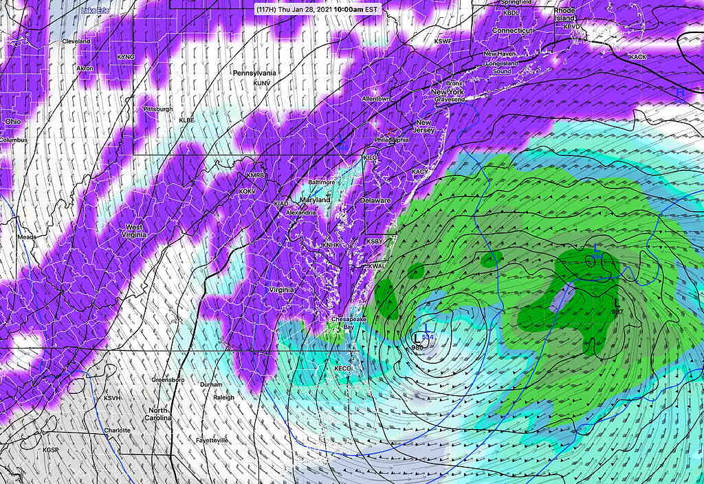
Currently, only about 1 inch of snow is expected with this Thursday storm.

Stay tuned.

COLDER, ACTIVE WEATHER PERIOD COMING UP

Thu 09:30 AM Update — What had been expected to be a colder, active pattern next week (title of original post) is unfolding to be a seasonably cold, uneventful pattern.   A flat and zonal flow as depicted in the “540  thickness” line (RED) of the Canadian Global model captures the uneventful flow and is NOT conducive to storm development—
Canadian Global model forecast for next Friday, Jan 22nd.  Red line (“540 thickness line”) couldn’t be much flatter and  it’s not conducive to storm development.  (Click on image for a larger view.)

We’ll have a dip in the jet this weekend with an upper low affecting our area, but the original expectation for a continued amplified pattern next week has faded. As for the very cold weather, temperatures in Canada have significantly chilled, but there’s no indication at this time that it will move down to affect our area.

Addendum: Here’s the current day temperature deviation compared to the period 1979-2000— 

GFS temperature anomaly Dec 14th compared to seasonal average 1979-2000. (ºC)  As cold as things are getting in northern Canada, temperatures are relatively warmer than average.  (Click on image for a larger view.)

Wed 09:48 AM Update — After looking at the latest GEFS (statistical ensemble) model as far out as it predicts -384 hours in the future – I don’t really see any intrusion of extremely cold air showing except in the far northwestern US.  In fact, the jet flow is looking rather ‘flat’, (not amplified) so previous expectations of an active pattern next week may be incorrect.  The flat pattern does not lend itself towards storm development.  Cold air starts building in as shown below in the forecast for Sat, Jan 23rd below, but that’s a ways off—
GEFS forecast Saturday Jan 23rd showing high pressure building in. (Click on image for a larger view.)

Tue 10:52 AM Update —  A plunge of cold air will cause low pressure development over our area Saturday.  It looks like RAIN for our area on Saturday.
Despite talk about  displacement of the”the polar vortex” as suggested by signs of “stratospheric warming”, current statistical models have deep cold in Canada, but not deep or cold enough to extend into the US at this time.  Current minimum temperatures from the statistical ensemble model (GEFS)—
Minimum Temps GEFS model for Monday 7 AM EST (Click on image for a larger view.)

This morning’s models are beginning to show an outbreak of very cold air around the last week of January.

Mon 06:22 PM Update — The pattern change expected over the weekend is still showing in the models.  It appears it will be too warm for snow here, but there’s high uncertainty about Saturday’s forecast. Low pressure is expected to develop along the coast or slightly inland, keeping us in the warm sector, maybe with a brief changeover to snow before ending Saturday. Stay tuned.  

This winter has been relatively quiet with average to above average  temperatures, and with the exception of one storm, not much snow. 

As mentioned in several posts over recent days, the models having been showing a strong signal towards a pattern change during the period January 16th through January 20th.

Colder air has been building in Canada and it appears that a southward plunge in this cold air will start occurring during the above timeframe, forcing a dip in the jet stream as a jet streak (1) causes the development of low pressure—

GFS version 16 forecast for Friday- 10 PM  (Click on image for a larger view.)

The models have not come together with exact timing and placement of this plunge.  The GFS (version 16) has rain, changing to snow for this first impulse: not a big storm. 

GFS 16 forecast Saturday, 1 AM  (Click on image for a larger view.)

The Canadian global model is similar to the GFS 16, with snow developing Saturday morning.

I should add that the current, operational GFS (version 15.2) is faster and does NOT have this storm form until the impulse is north of us—

Current Operational GFS version 15.2 Forecast for 1 PM Friday


Either way, colder temperatures are expected next weekend.

On the horizon is another impulse (#2 above), which depending upon the model, shows the possibility of a significant nor’easter a few days later.

It’s way too early to really know specifics, but the take-away is that colder temperatures are on the way next weekend and a more active winter weather pattern likely follows.

SNOW UPDATE

This is a quick update. The model blend (NBM) continues to forecast a major snowstorm starting Wednesday afternoon and ending around daybreak Thursday. Snow totals 10-18 inches. See graphic below—

Latest NBM snowfall 75 percentile  forecast at 7 AM Thursday.  (Click on image for a larger view.)

The NAM and NAM-NEST continue with snow mixing with rain, reducing totals.    We likely won’t have a handle on this until Tuesday night or Wednesday morning.  Stay tuned.