Category Archives: Winter Storm Outlook

SNOW FORECAST UPDATE 7 PM EDITION

This afternoon’s models continue with the fact that this is a difficult forecast—too many boundary conditions which affect the precipitation type and amount.   The GFS has a QPF of only 0.30 inches water, the NAM has a consistent QPF of 0.60 inches water.

Here are the issues making this forecast difficult-

  • Temperatures during the daytime Saturday are expected to be well above freezing, with the GFS much warmer than the NAM.
  • Ground temperatures, especially on paved surfaces are slow to drop, reducing accumulations.
  • Critical temperatures in the lower atmosphere support snow, BUT the models agree that critical thickness levels (a measure of the upper atmosphere temperature and density) are a bit warm to support snow at several points during the 7 hour precipitation window.

As a result, it looks like a mix of snow, sleet or rain is likely in PHL and the immediate suburbs.    So what falls from the ground may be snow, but it may switch over to  sleet and rain and then end as snow.   Add the warm ground temperatures to the mix and it’s truly not possible to predict accumulations.

More specifically, it looks like it starts as snow about 4 PM, but I think it will mix with sleet and freezing rain for a portion of the duration, then switching back to snow before ending about 2 AM Sunday.   Most accumulations will be on non-paved surfaces.

Areas in northern Montgomery and Bucks county will likely have more snow.

Temperatures are key- the next model run with the data I need will be available about 9:45 PM.


SNOW POSSIBLE FOR PHILLY SATURDAY NIGHT!

The models have been all over the place this winter —There’s been a general lack of continuity with forecasts.   Just a few days ago, it appeared that we would not have any chance of snow through the end of February.   How things have suddenly changed.

After a warmup on Thursday and early Friday, a frontal boundary moves through on Friday allowing cold air to return to our area. A low pressure system is may develop along the mid-Atlantic coast during the day and evening on Saturday resulting in a possible significant snowfall by Sunday morning.     Currently, QPF values are as high as 0.60 inches water with this afternoon’s NAM, but that looks high.

It’s important to note that several forecasted potential storms have not panned out this winter.  The GFS and the NAM have been slow to pick up this possibility, although the EMCWF (European) and Canadian models have been suggesting the possibility for a few days.  There remains significant spread in timing, position and intensity among the models, so confidence in predicting any feature of this storm is below average at this time.   Furthermore, the earlier GFS model had the rain-snow line right near PHL, while the latest NAM has trended much colder, implying more snow.   Additionally, the storm is a fast mover, likely reducing precip totals.

I’ll keep my eye on things and will update over the next few days.

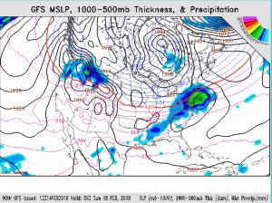
GFS Sunday evening

Super Bowl Snow?

Possibly two centers of low pressure are expected to develop along a frontal boundary moving through our area later Sunday.  The statistical models are highly scattered with the position of the low centers, but the latest GFS has the rain-snow line moving west to east during Sunday evening and early Monday.

A complex snow -> rain -> snow transition is possible with this storm. QPF values over 1 inch water are predicted by the NBM, suggesting a possible significant snowfall, particularly areas west of I-95.

Below average  confidence at this time, but things should come into focus over the next day or so. Stay tuned.