Category Archives: Philadelphia Weather Outlook

WEEKEND OUTLOOK & BEYOND

I’m always looking to find the best way to offer the most transparency to the process of weather forecasting.  Recent feedback suggests that my attempts to show all updates/edits may have made the forecasts too confusing. 


Going forward, I’m inclined to have any update to the initial post contained in a single update box; previous updates will be deleted. But let’s hear what YOUR preferences are.

[yop_poll id=”2″]


Updated on Fri 8:50 AM in the green box below
Updated on Thu 7:50 PM in the box below
Updated on Thu 8:35 AM in the box below

The coming weekend will be a transitional time for the current weather pattern.

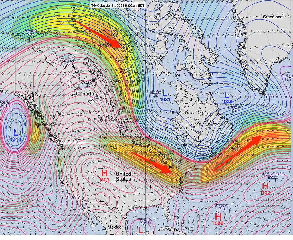
The current highly amplified jet flow trough that’s giving us such cool weather will transition by Sunday to a more typically hot summer upper air ridge with a Bermuda high as shown below—

  • Current amplified trough

The current GFS and NBM show sunny skies with a slight chance of a shower Saturday late afternoon or evening, followed by sunny, hot and humid weather for Sunday.

Updated on Fri 8:47 AM The general forecast trend is for more clouds on Saturday, but most models are keeping any showers mostly southeast of Philadelphia area until evening hours.

Sunday will feature an upper air low centered over Philadelphia and a surface low off of the coast. The models are keeping the showers far east right now with a mix of sun and clouds on Sunday.

Both days will feature hot and humid weather, but not as hot and humid as previously forecast. Temps 88-90 with dew points in the low to mid 60s.

Check back for the Weekend Weather forecast this evening.

Thu 07:49 PM Update — What had appeared to be a slam-dunk weekend forecast now appears much cloudier, both literally and figuratively. This afternoon’s GFS model suggests an upper low lingers over the area on Sunday, with clouds and showers. Too soon to trust the GFS, since it’s an outlier with the other models. We’ll have a better handle Friday morning. Don’t be surprised if the forecast for the weekend changes considerably.
Thu 08:48 AM Update — Last night’s models have more clouds Saturday ahead of a warm front and a somewhat increased chance of showers/thunderstorms in the evening. High temperatures in the upper 80s.

The high temps will be in the upper 80s Saturday and just above 90º for Sunday.

Currently, the longer range models show all of next week to be very hot, humid and rain-free with high temps in the low 90s and dewpoints in the uncomfortable 70º range. With the exception of a widely scattered or isolated thunderstorm, much of the upcoming week looks to be dry.

ON THE COOLER SIDE OF THINGS

While extreme heat will continue to bake the middle of the country, the Philadelphia area will trend towards cooler temperatures by the end of the week. (The pattern that will set up is similar to the less humid, pleasant weather that we experienced last Thursday through Saturday.)

The dip in the position of the jet stream can readily be seen on the GEFS model position of winds at about 31,000 feet (250 mb). The red arrows overlay the ‘jet streaks’, areas of higher winds within the overall flow—

GEFS 250 mb forecast for Saturday at 5 AM. Notice the position of the jet streaks (red arrows), areas of enhanced winds.

The position of the jet stream is important, but equally important is the location of the jet streaks.

Areas on either end of the jet streaks are referred to as the “entrance and exit regions”.

Jet streak showing entrance and exit regions with different upward/downward motions depending on the specific side of the jet.

On the side of these regions you will find rising or falling vertical motions, causing rain, clouds, or nice weather. While the winds in the jet stream move in excess of 100 mph, the jet streak areas move along at a much slower speed.

Next Saturday looks to be very nice. We’ll be in the right exit region of the jet streak, with downward vertical motion.

Next Sunday, we’ll be in the right entrance region of the jet streak. A surface trough will develop and will move through next Sunday evening with possible showers/thunderstorms.

THURS HEAVY RAIN & WEEKEND OUTLOOK

With a complicated forecast, let’s try a different approach. I’m going to use two different model’s meteograms showing precipitation for Blue Bell, PA. (remember that a meteogram only shows the weather for one specific location; the Jersey shore’s meteogram may look much different for the same time frame.)

Both show heavy rain (1 inch) starting about 2 PM Thursday afternoon.

The ICON shows significant rain again on Saturday. The model blend does not. (Not shown here, the GFS has showers in the late afternoon Saturday.) Both show Sunday and Monday essentially rain free.

ICON model—

ICON model rain meteogram for Blue Bell, PA Is it over-doing the rain on Saturday? (The GFS only has rain in the afternoon on Saturday.) Why the ICON model? It did well with last night’s rain, while the GFS model totally over-predicted last night’s rain. (Click on image for a larger view.)

Important clarification: the meteogram times indicate prior 1 hour accumulations. If you were to take those times as literal (and you shouldn’t), it would mean that the actual rain start times could have been as much as 1 hour earlier. Accumulation also does not show light rain that might not have accumulated enough to show in the scale of the meteogram.

NBM —

NBM meteogram for Blue Bell PA (Click on image for a larger view.)

So after some heavy rain Thursday and early Friday, much of the Fourth of July weekend may be relatively rain free. (Considerable clouds on Saturday with possibly some showers in the afternoon, according to the GFS.)

Sunday and Monday look much better weather-wise.

It will be cool on Saturday (high in the 70s) and still below average highs on Sunday (about 80º)