Category Archives: Philadelphia Weather Outlook

ACTIVE WEATHER PATTERN EXPECTED

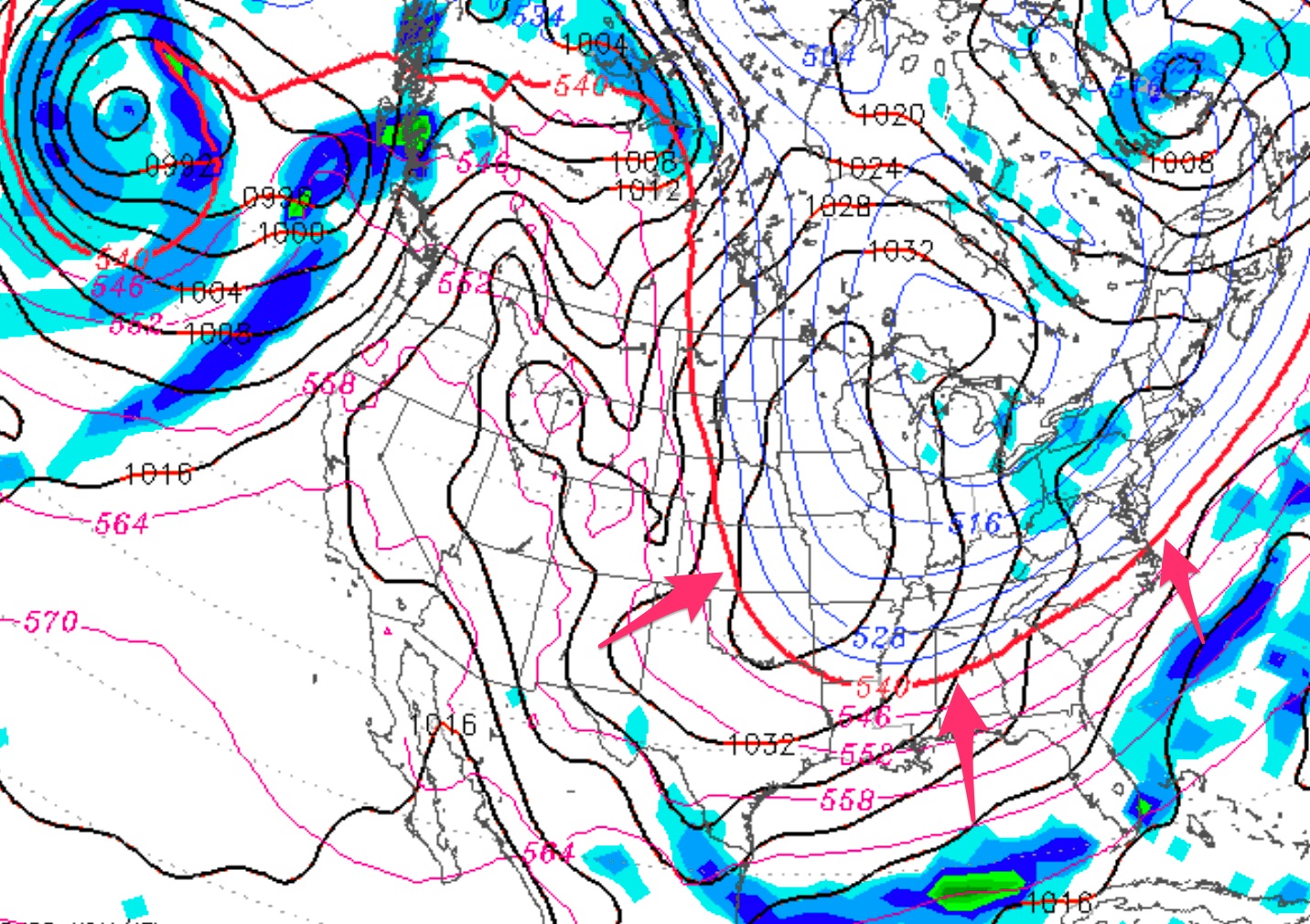
Thursday Update:  Notice how significantly the predicted jet stream trough for Monday has changed over the past few days:

  • GFS forecast
    GFS Forecast for Monday Morning, Nov 12th

The weekend remains cold, but the temperatures on Monday will be warmer than had been predicted.   Very cold temperatures are now forecast for Tuesday night into Wednesday.

[su_note note_color=”#d9f2da”]The current outlook for this weekend is dry, windy and chilly on Saturday and mostly sunny and chilly on Sunday. [/su_note]


My post last Sunday identified the cold outbreak that’s expected this weekend. With the amplification of the jet stream and the development of a significant trough by next Tuesday, a coastal system is expected to develop and to bring rain to our area, and some snowfall is possible in western PA.

Even more interesting is that the FV3-GFS (still under development but expected to become the NWS main global model in January) suggests that even some wet snow flakes may move in  during the end of the storm Tuesday night.

This outbreak of cold weather will be the first of several, with a number of storms expected between now and Thanksgiving.   Stay tuned.

VERY COLD WEATHER POSSIBLE NEXT WEEKEND

[su_box title=”Monday Update” box_color=”#defcdc” title_color=”#000000″]It appears that the cold snap in our area will be delayed a bit and will likely occur late Sunday night into Tuesday.  Monday’s models show a slightly less amplified jet stream.

Tues update: Some of the models are showing a coastal storm developing as a result of this jet dip next Tuesday with some snow falling in western PA and possibly further east.   [/su_box]

So far, the autumn season has been a mix— a very mild and rainy September and plenty of rain in October.

This week we will have another few days of mild weather, but things are setting up for a change to much colder weather, at least for a period, sometime next weekend.

Over the past few days, the  medium and long range models have been showing a cold short term pattern developing the end of next weekend that one would expect to see in winter— a highly amplified jet stream, allowing unseasonably cold air to flood into the US.

Here’s the current operational GFS for next early Monday, showing the highly amplified jet stream for early November:

GFS forecast
GFS Forecast for Monday Morning, Nov 12th

This amplification is impressive for this early in the season.

So, get your winter coat ready, at the very least, for next weekend.

By the way, above average temperatures will likely return after this cold outbreak.


WEEKEND WEATHER OUTLOOK

A somewhat uncertain forecast for Saturday with a likely fine weather day on Sunday.

A dip in the jet stream in the central US will cause a front to move through sometime in the Friday to Saturday time frame.  There’s uncertainty with the timing of the frontal passage. Several models show different timing and differ in developing waves of low pressure along the front Friday into Saturday.

Rain likely Friday morning and Friday night into Saturday morning.  It’s unclear if the waves of low pressure will move off the coast to allow clearing Saturday afternoon.

High pressure builds in for Sunday.  Cooler on Saturday and Sunday.

I’ll update on Friday.